Tornado warnings, watches issued for several Florida counties as strong storms move east
LATEST UPDATES
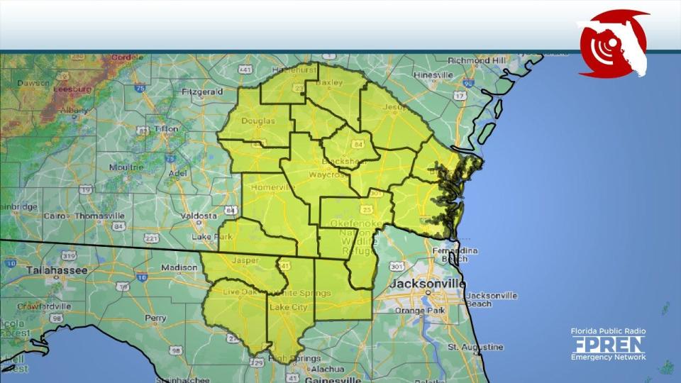
Tornado watch issued for Ocala, parts of northeast Florida
5:00 p.m. ET: The National Weather Service in Jacksonville has issued a tornado watch for Marion, Flagler, Putnam and St. Johns counties until 6 p.m. ET.
Tornado watch issued for 4 North Florida counties
2:30 p.m. ET: A tornado watch has been issued for Bradford, Clay, Duval and Union counties until 4 p.m.
Line of storms moving farther south
The line of storms in place ahead of a cold front will be moving into the northern Nature Coast over the next hour. This line will be slowing down and weakening as it settles southward across the area overnight and Thursday. #flwx pic.twitter.com/C3G5apEOHW
— NWS Tampa Bay (@NWSTampaBay) January 4, 2023
1:58 p.m. ET: The line of storms moving through Florida ahead of a cold front are expect to move into the northern Nature Coast over the next hour. The storms are forecast to slow down and weaken as they move south across the area overnight and into Thursday.
Tornado warning issued for Baker, Columbia counties
1:41 p.m. ET: A tornado warning has been issue for Baker and Columbia counties until 2:15 p.m.
At 1:40 p.m., a severe thunderstorm capable of producing a tornado was located 7 miles northeast of Watertown, or 8 miles northeast of Lake City, moving northeast at 45 mph. Radar indicated the presence of a tornado.
The National Weather Service reported the tornadic thunderstorm will remain over mainly rural areas of west central Baker and east central Columbia counties.
Tornado watch issued for Nassau County
12:55 p.m. ET: A tornado watch has been issued for Nassau County until 2 p.m.
Tornado watches issued for portions of North Florida
8:40 a.m. ET: A new tornado watch has been issued, this time across North Florida. The tornado watch is in effect for: Baker, Columbia, Hamilton and Suwannee counties. The watch is in effect until 8:37 a.m. ET.
Meteorologist Jim Cantore tweeted at 8:46 a.m. a tornado was on the ground southeast of Blountstown.
Tornado on the ground se of Blountstown, FL pic.twitter.com/U23gvK81ov
— Jim Cantore (@JimCantore) January 4, 2023
Tornado warnings issued for several Panhandle communities
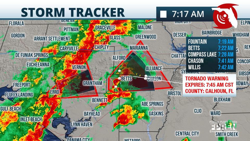
7:21 a.m. CT: Two tornado warnings are in effect right now: One over Walton, Bay, and Washington counties, the other over over Jackson, Bay, and Calhoun counties. according to the Florida Public Radio Emergency Network.
At 7:22 AM, a severe thunderstorm capable of producing a tornado was located 7 miles southeast of Graceville, moving northeast at 40 mph, according to the National Weather Service. Radar indicated a tornado. The warning in for northwestern Jackson County is in effect until 8 a.m.
The dangerous storm is forecast to be near Cottonwood around 7:40 a.m. Other locations impacted by this tornadic thunderstorm include Malone, Bascom, Jacob City, Grangeburg, Jacobs, Campbellton and Sills.
Residents are advised to move to a safe location.
The other tornado warning is in effect until 7:45 a.m. for south central Jackson County, northeastern Bay County and northern Calhoun County.
At 7:15 a.m., a severe thunderstorm capable of producing a tornado was located 19 miles southeast of Vernon, moving northeast at 35 mph.
This tornadic thunderstorm will remain over mainly rural areas of south central Jackson, northeastern Bay and northern Calhoun Counties, including the following locations: Betts, Moose Pond, Red Oak, Altha, Fountain, Chason,Union City, Chipola, Henderson Mill and Camps Head.
Tornado watch, severe thunderstorm watch in effect for Okaloosa County
Severe Thunderstorm Warning for Holmes, FL; Walton, FL; Washington, FL from Wed Jan 4 6:19 AM until Wed Jan 4 7:00 AM. Wind gust: 60 MPH. Hail size: Up to .75 inches. #FLwx pic.twitter.com/kDZfYmPp0R
— Florida Storms (@FloridaStorms) January 4, 2023
5:35 a.m. CT: Tornado watch remains in effect until 11 a.m. for Okaloosa and Santa Rosa counties.
A severe thunderstorm watch has been issued for southeastern Okaloosa County. At 5:55 a.m., a severe thunderstorm was located 4 miles south of Fort Walton Beach, moving northeast at 50 mph. Hazards include 60-mph wind gusts.
EARLIER STORY
Tornado watches have been issued across several areas of Florida's Panhandle.
Earlier this morning, a tornado watch was issued for three Florida counties until 11 a.m. CT. The watch was in effect for Escambia, Okaloosa and Santa Rosa counties, according to the National Weather Service.
Strong thunderstorms are moving through the area ahead of a cold front. Hazards from the storms include possible tornadoes, strong winds with gusts up to 40 mph winds and hail.
By 6:30 a.m. CT, Escambia County had been removed from the watch area.
Cold front on its way:Tornadoes, hail possible across portions of Florida ahead of first cold front of 2023
The storms affecting Florida's Panhandle Wednesday are part of a storm system that hit the Plains earlier this week and prompted several tornado warnings in Louisiana and Mississippi, according to AccuWeather.
The threat of thunderstorms will extend from the Florida Gulf Coast into the central Appalachians this morning. As the day progresses, severe thunderstorms could develop from the Florida Panhandle to as far north as central Virginia during the afternoon and evening hours.
Strong thunderstorms could move into Tallahassee later today. Storms could bring isolated tornadoes, local flash flooding and wind gusts up to 60 mph.
What areas are included in the tornado watch?
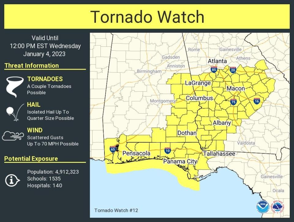
Three counties are under a tornado watch until 11 a.m. CT: Escambia, Okaloosa and Santa Rosa.
The watch includes the following cities: Andalusia, Atmore, Bay Minette, Bellview, Brent, Brewton, Crestview, Daphne, Destin, Eglin Air Force Base, Ensley, Ferry Pass, Flomaton, Fort Walton Beach, Gulf Breeze, Gulf Shores, Milton, Myrtle Grove, Niceville, Opp, Pace, Pensacola, Seminole and Wright.
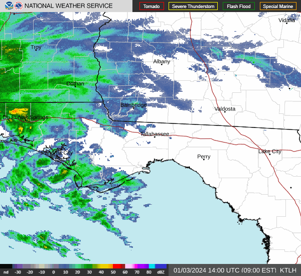
Weather radar, Pensacola: Track storms as they move through the Panhandle
Pensacola weather forecast for today
Showers and thunderstorms likely before 9 a.m. Cloudy through mid morning, then gradual clearing, with a high near 74. Southwest wind 5 to 15 mph becoming northwest in the afternoon. Winds could gust as high as 25 mph. Chance of precipitation is 70%. New precipitation amounts between a half and three quarters of an inch possible.
Weather radar, Tallahassee: Track storms as they move east
Tallahassee weather forecast for today
Showers and thunderstorms, mainly before 4 p.m. Areas of dense fog before 8 a.m. High near 75. South wind 5 to 10 mph, with gusts as high as 25 mph. Chance of precipitation is 100%. New rainfall amounts between three quarters and one inch possible.
How low will temperatures drop as the cold front moves through?
Highs for the first full weekend of 2023 will fall into the upper 50s and lower 60s across the northern half of Florida, with lows in the upper 30s and lower 40s.
For Central Florida, highs could drop into the upper 60s to the 70s, with lows in the lower to mid 50s over the weekend before jumping back up again.
South Florida could see temperatures drop into the low to mid 50s over the weekend, with highs in the mid to upper 70s.
The cooldown is expected to be brief, as temperatures begin to warm back up into next week.
This article originally appeared on Treasure Coast Newspapers: Florida weather forecast: Tornado watches, warnings issued

