Possible tornado touched down south of Richmond County line. No injuries reported
The Burke County Sheriff's Office reported a possible tornado touched down south of the Richmond County line earlier this morning.
Trees were reported down across roads, homes and power lines. No injuries have been reported.
Damage seems to be in the area of Story Mill, Greiner Highway 25, McManus, Allen and Old Waynesboro.Officials are in the area.
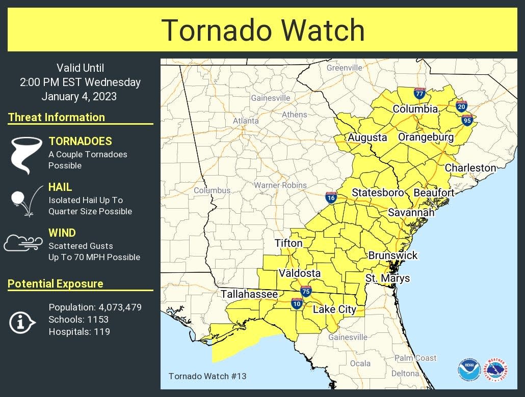
A tornado watch remains in effect across much of southeastern Georgia.
The watch is in effect until 2 p.m. as a line of strong storms moves east.
Counties in the tornado watch area include: Appling, Atkinson, Bacon, Ben Hill, Berrien, Brantley, Brooks, Bryan, Bulloch, Burke, Camden, Candler, Charlton, Chatham, Clinch, Coffee, Colquitt, Columbia, Cook, Echols, Effingham, Emanuel, Evans, Glynn, Irwin, Jeff Davis, Jenkins, Lanier, Liberty, Lincoln, Long, Lowndes, McDuffie, McIntosh, Montgomery, Pierce, Richmond, Screven, Tattnall, Telfair, Thomas, Tift, Toombs, Treutlen, Ware, Wayne and Wheeler.
Showers and thunderstorms will continue across north and central Georgia this morning and afternoon ahead of an advancing cold front. Several storms could become severe, capable of producing damaging wind gusts, brief tornadoes and frequent lightning, according to the National Weather Service.
Locally heavy rainfall through the afternoon could lead to flash flooding and river flooding concerns. A flash flood warning is in effect for some areas in north central and northeastern Georgia until 1:45 p.m. A flood watch remains in effect for portions of north and central Georgia until 7 p.m.
Weather radar, Savannah: Track storms as they move through Georgia

Weather
Embedded content: https://radar.weather.gov/ridge/standard/KCLX_loop.gif?
Savannah weather forecast for today
Showers and thunderstorms before 4 p.m., then showers likely and possibly a thunderstorm between 4 p.m. and 5 p.m., then a chance of thunderstorms after 5 p.m.
Some storms could be severe, with damaging winds. High near 78. South wind 13 to 16 mph. Chance of precipitation is 100%. New rainfall amounts between a tenth and quarter of an inch, except higher amounts possible in thunderstorms.
Weather radar, Augusta: Track storms as they move through Georgia

Weather
Embedded content: https://radar.weather.gov/ridge/standard/KCAE_loop.gif?
Augusta weather forecast for today
Showers and possibly a thunderstorm, mainly before 5 p.m., then a chance of showers and thunderstorms after 5 p.m. High near 73.
Southwest wind 10 to 13 mph, with gusts as high as 23 mph. Chance of precipitation is 90%. New rainfall amounts between a quarter and half of an inch possible.
Athens weather forecast for today
Showers and thunderstorms, mainly before noon. High near 71. West wind around 10 mph, with gusts as high as 15 mph. Chance of precipitation is 90%. New rainfall amounts between a quarter and half of an inch possible.
This article originally appeared on Savannah Morning News: Georgia: Tornado watch, flood warnings issued ahead of strong storms

