Tornadoes, hail possible across portions of Florida ahead of first cold front of 2023
Another cold front is moving toward Florida and ahead of it is a line of severe storms that could bring damaging winds, large hail and tornadoes to the Panhandle today and into Wednesday.
Severe thunderstorms are expected to reach Northeast Florida Wednesday.
As the line of storms moved east across the Midwest, tornado warnings were issued Tuesday morning from Louisiana into Kentucky. Winter storm and ice storm alerts also were issued in the Midwest. The severe weather is moving east and is forecast to impact residents from Birmingham, Alabama, to New Orleans today.
Severe storms will be possible as far east as Florida's Panhandle today and continue into Wednesday ahead of the line of thunderstorms, according to the Florida Public Radio Emergency Network.
When are severe storms expected to arrive?
A line of thunderstorms is forecast to move into the Panhandle after sunset today, probably between 10 tonight and 4 a.m. Wednesday.
As the cold front pushes east Wednesday, the risk of severe weather will gradually shift farther east into the Big Bend area of the state.
The National Weather Service in Tallahassee warned residents two rounds of severe weather are possible over the next 36 hours, with the first system impacting southeast Alabama and the Panhandle late this afternoon.
The Storm Prediction Center has the far western Panhandle under an "enhanced" risk for severe weather Tuesday, which means severe storms will be capable of producing a few strong tornadoes.
California flooding1 dead in California flooding after storm soaks San Francisco, causes power outages
Florida airport delays'FAA control plan' caused flight delays at some Florida airports
By Wednesday, the severe weather risk will shift toward the Big Bend as a "marginal" risk, which means storms will be isolated and capable of producing damaging wind and a few brief tornadoes.
Severe thunderstorms are forecast to reach Northeast Florida Wednesday afternoon and evening, according to the National Weather Service Jacksonville.
What could be the impact from the system moving through the Panhandle and Northeast Florida?
#GOESEast imagery from early this morning is tracking the lightning flashes from severe thunderstorms rolling across the southern U.S.
High winds, large #hail, and at least two #tornadoes have been reported from Texas to Kentucky.
Latest: https://t.co/YPPZF02wT8 pic.twitter.com/n7uD5NiAT3— NOAA Satellites (@NOAASatellites) January 3, 2023
Damaging winds in excess of 60 miles per hour and large hail of an inch in diameter are possible. Upper-level winds will be changing direction and wind speed, which could develop into a few supercells capable of producing tornadoes.
The potential for damaging winds will continue as a broken line of thunderstorms pushes into North Florida Wednesday.
The National Weather Service in Mobile/Pensacola said wind gusts up to 60 mph were possible, along with large hail and tornadoes.
The National Weather Service in Tallahassee told residents wind gusts near 60 mph and a few strong tornadoes are possible later today and into the evening.
Severe storms are forecast to reach Northeast Florida Wednesday, bringing strong winds and isolated tornadoes, according to the National Weather Service, Jacksonville. The potential for storms stretches from from Gainesville to Jacksonville.
Have any watches or warnings been issued?
No watches or warnings have been issued at this time but there is a potential for some to be issued later today and into Wednesday, according to the Florida Public Radio Emergency Network.
If a watch is issued, it means conditions exist for severe weather or tornadoes. Watches are usually issued before the weather turns severe and tend to cover a fairly large geographic area for several hours.
A warning is issued during severe weather for a specific location, typically covering only a few counties at a time.
How low will temperatures drop as the cold front moves through?
Highs for the first full weekend of 2023 will fall into the upper 50s and lower 60s across the northern half of Florida, with lows in the upper 30s and lower 40s.
For Central Florida, highs could drop into the upper 60s to the 70s, with lows in the lower to mid 50s over the weekend before jumping back up again.
South Florida could see temperatures drop into the low to mid 50s over the weekend, with highs in the mid to upper 70s.
The cooldown is expected to be brief, as temperatures begin to warm back up into next week.
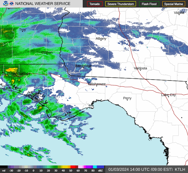
Weather radar, Pensacola: Track storms as they move toward the Panhandle
Weather radar, Tallahassee: Track storms as they move east
This article originally appeared on Treasure Coast Newspapers: Florida weather forecast: Strong storms bring tornado, hail threat
