Towering dust devils, ancient dunes, and avalanches: 12 stunning images from NASA's Mars orbiter on its 15th anniversary

NASA/JPL-Caltech/Univ. of Arizona
NASA's Mars Reconnaissance Orbiter has taken nearly 7 million pictures of the red planet since leaving Earth 15 years ago.
From dust storms to avalanches, the images reveal details of Mars' surface and weather patterns.
Here are 12 of the most beautiful visuals the orbiter has captured so far.
NASA's Mars Reconnaissance Orbiter left Earth on August 12, 2005 — almost exactly 15 years ago. The satellite began circling the red planet on March 10, 2006, and since then it has studied Martian temperatures, detected minerals on the planet's surface, and taken nearly 7 million images of our closest planetary neighbor.
The orbiter's main goal is to help scientists understand the role water has played on Mars throughout the planet's history, and the degree to which water still exists on the planet as liquid, vapor, or ice.
In honor of the orbiter's 15th anniversary, here are some highlights from its massive portfolio of photos, and what each image reveals about Mars.
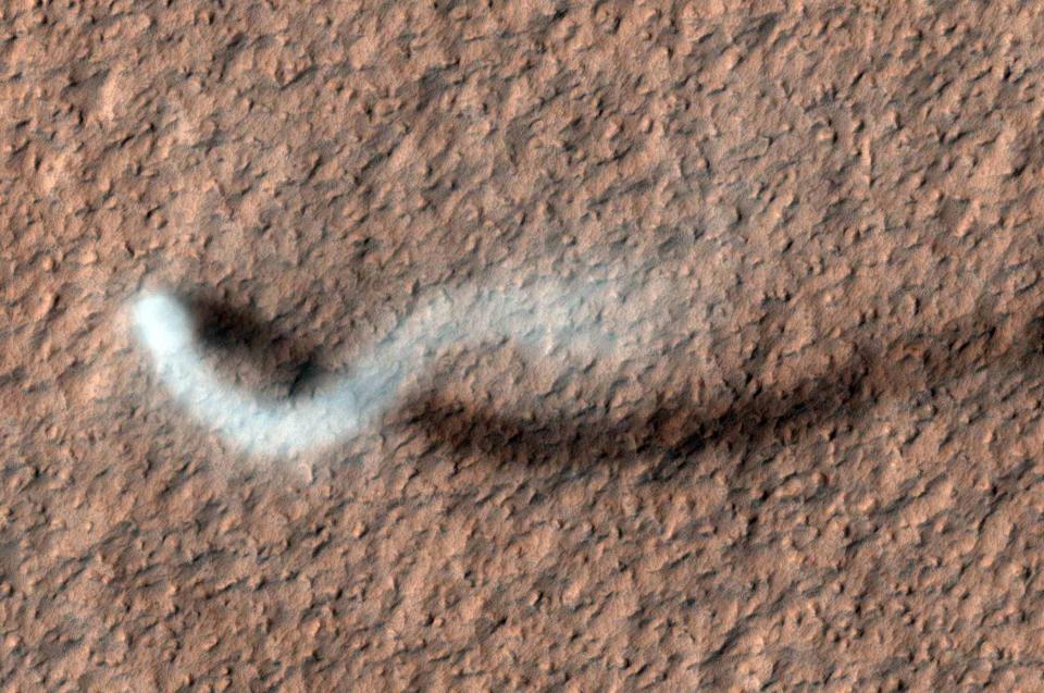
Mars is full of dust devils — millions form and die on the planet each day.
NASA/JPL-Caltech/Univ. of Arizona
The dust devil in this photo snakes 185 miles above Mars' surface. Such dust devils hurl heat-trapping dust into the air, which impacts the planet's weather patterns.
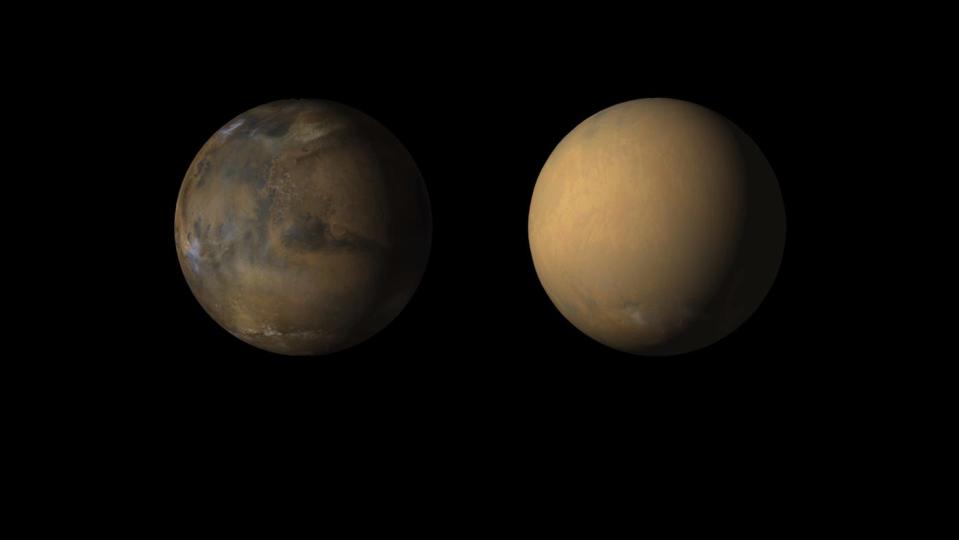
A giant, once-in-a-decade dust storm swept over Mars in the summer of 2018. The dust clouded the solar panels of NASA's Opportunity rover, cutting off its power. Nobody has heard from the rover since June 10, 2018.
NASA/JPL-Caltech/MSSS
Most dust storms on Mars occur on isolated sections of the planet. But every 10 years or so, regional storms combine into a huge one that covers the entire surface.
The animated graphic above shows the planet in May 2018, before the dust storm began, then in June, when it hit full force.
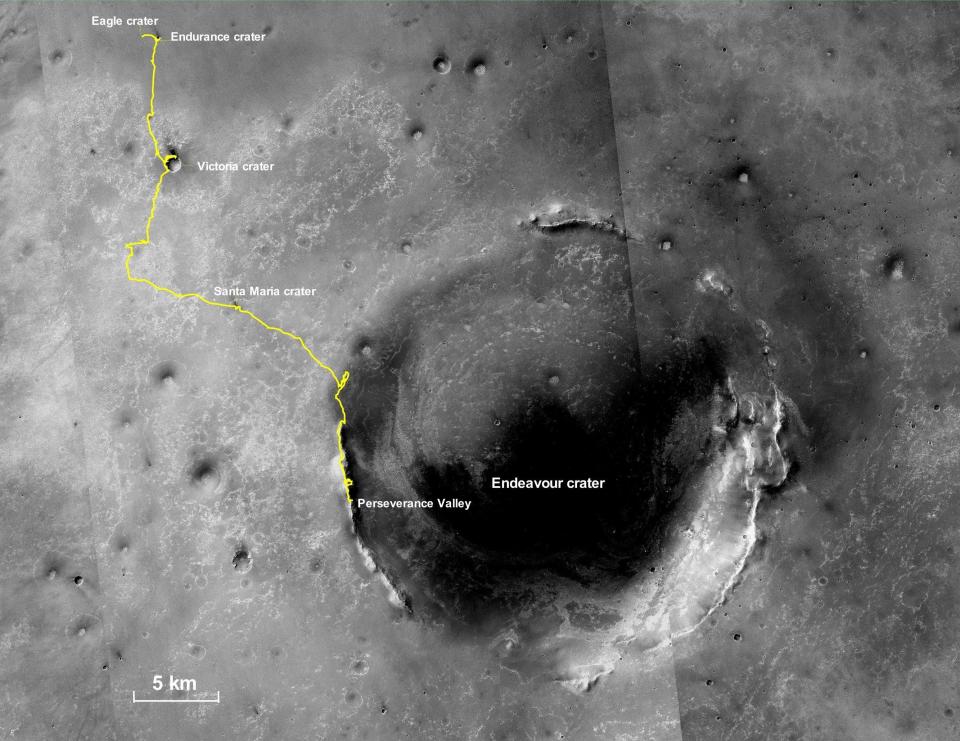
The orbiter captured the journey of the Opportunity rover, which was originally designed for a 90 day mission. The rover explored Mars for more than 14 years.
NASA/JPL-Caltech/MSSS
This illustrated image shows the entire 28-mile path of Opportunity, from its landing site in the Eagle Crater to Perseverance Valley, the site of its final transmission.
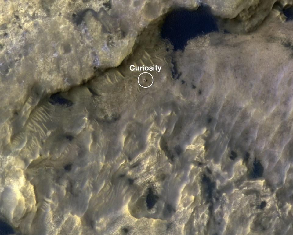
Mars' Curiosity rover, meanwhile, is still alive. The orbiter has watched Curiosity traverse the Gale Crater — it has traveled more than 14 miles since it landed in August 2012.
NASA/JPL-Caltech/University of Arizona
This animated image shows the rover before and after it made a journey of 1,106 feet across Mount Sharp, a mountain within the Gale Crater.
Mars' surface is covered in giant ripples and dunes.
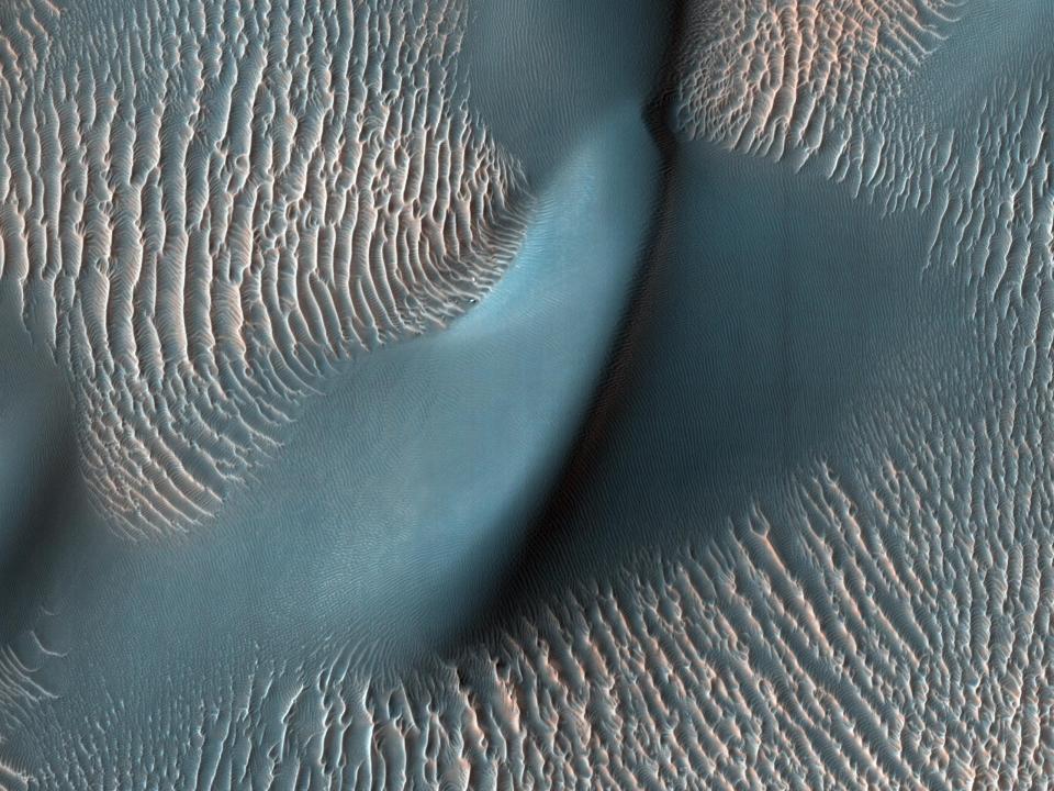
NASA/JPL-Caltech/University of Arizona
This photo, taken by the orbiter's High Resolution Imaging Science Experiment (HiRISE) camera, captures huge, cresting waves of sand called megaripples, along with a large dune.
Warmer weather brings giant avalanches to the red planet. The 2019 avalanche shown here plummeted down a 1,640-foot cliff.
NASA/JPL-Caltech/University of Arizona
In the Martian spring, warmer air vaporizes ice chunks in Mars' North Pole, causing these giant avalanches.
Known as brain terrain, this kind of pockmarked land on Mars remains a scientific mystery.
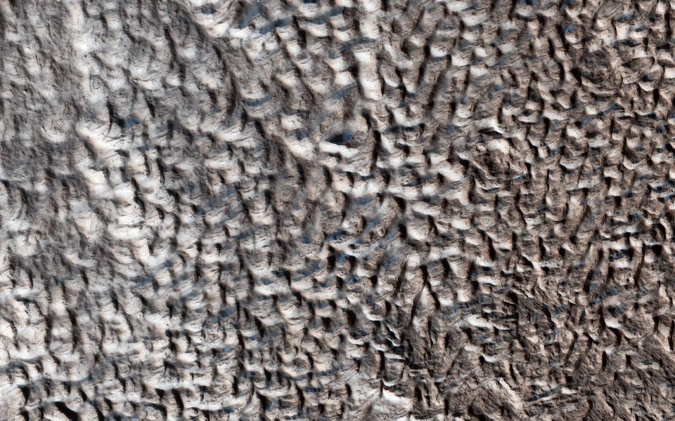
NASA/JPL-Caltech/University of Arizona
Stretches of brain terrain can be found throughout mid-latitude regions of Mars. Some scientists think that these land areas sit on top of an icy core, so when chunks of underground ice vaporize, they cause sections of land above them to collapse.
Dark sands streak across Mars' surface in its summer, then fade by winter. Scientists used to think flowing water caused these streaks, but most now believe they're caused by dark sand sliding down slopes.
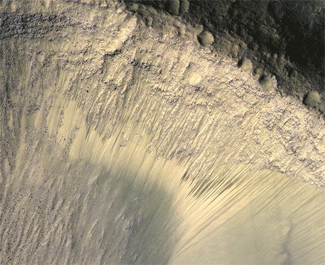
NASA/JPL-Caltech/Univ. of Arizona
Some scientists think salty sand grains might pull water vapor from the atmosphere as it warms, causing those grains to darken and tumble downward. The phenomenon is known as recurrent slope lineae.
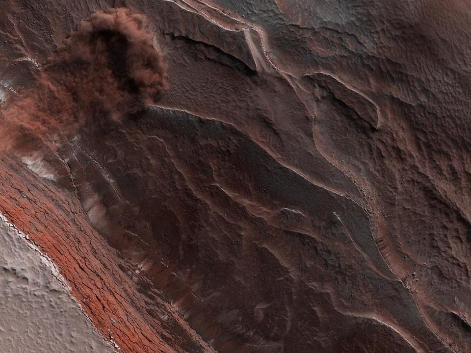
Large, pitted mounds on the red planet may contain methane.

NASA/JPL-Caltech/Univ. of Arizona
These large mounds contain craters at their center that resemble the collapsed centers of volcanoes on Earth. The pitted mounds may contain methane — a topic of interest for researchers, since it's not yet known whether Mars' methane comes from geologic events, microbial life, or both.
Because Mars' atmosphere is much thinner than Earth's, it doesn't burn up meteors as efficiently. So many large chunks of rock blast the planet's surface, creating large craters.
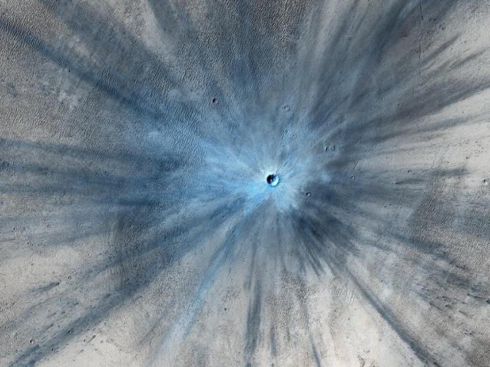
NASA/JPL-Caltech/Univ. of Arizona
The crater in this photo is roughly 100 feet wide, with a much larger blast zone around it.
The orbiter has also photographed Mars' two moons. The larger, Phobos, is just 13 miles across.
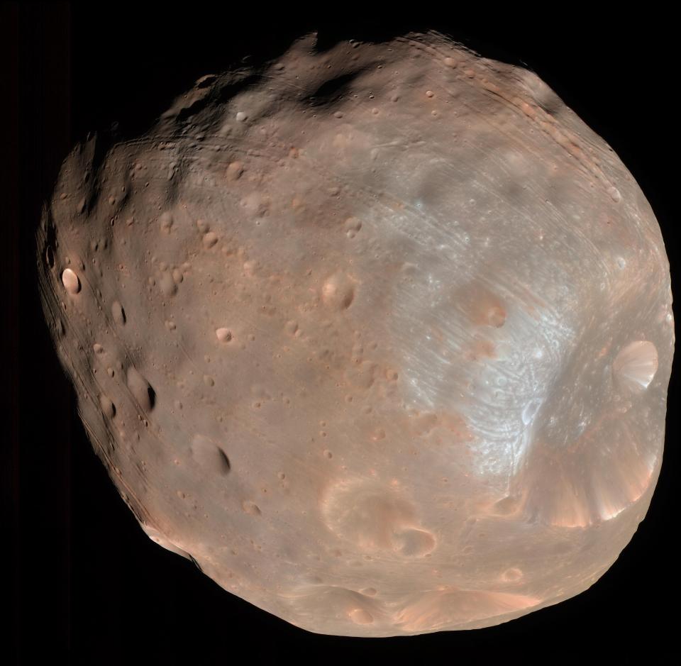
NASA/JPL-Caltech/University of Arizona
Scientists still don't know whether Phobos is an asteroid that entered the red planet's orbit or a chunk of Mars that broke off and became a moon millions of years ago.
Mars's other moon, Deimos, is even tinier than Phobos: It's only 9 miles across.
Occasionally, the orbiter's camera also turns back toward Earth.

NASA/JPL-Caltech/Univ. of Arizona
This composite photo was taken when Mars was about 127 million miles from Earth. Photo processors brightened the moon so to be visible next to our much brighter home planet.
Read the original article on Business Insider

