Travel Alert | Snow for Tri-Cities. Heavy snow in mountains, ice storm in Columbia Gorge
More snow is forecast for the Tri-Cities as the temperature warms some, although not back to normal for mid-January.
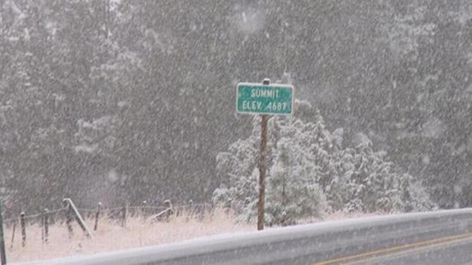
Travel could be challenging for people heading out-of-town this week, whether across Washington state’s Cascade or Blue mountains or down the Columbia River Gorge.
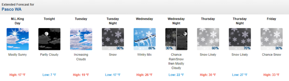
For the Tri-Cities the National Weather Service predicts a 90% chance of snow Tuesday night with 1 to 2 inches possible.
Snow may continue to fall Wednesday until 1 p.m., with less than 1 inch of additional snow forecast.
Wednesday afternoon precipitation could fall as freezing rain, possibly mixed with rain and snow.
Thursday a 60% chance of snow is forecast, increasing to 70% Thursday night, according to the weather service.
It predicts a chance of snow Friday and than a chance or rain and snow through the weekend in the Tri-Cities.
Normal lows for January are 28 degrees, but temperatures dropped as low as 2 on Saturday and 4 on Sunday. Temperatures would have had to drop below zero to set a daily cold weather temperatures.
Monday night a low in the single digits was forecast, increasing to 17 on Tuesday night and then into the 20 from Wednesday night through Friday night.
Highs should climb from the teens forecast for Monday and Tuesday night into the 20s on Wednesday and the 30s from Thursday through Sunday.
Normal highs for mid January in the Tri-Cities are about 41 degrees.
Washington mountain travel
Travel will continue to be challenging for those crossing the Washington Cascade Mountains and the Oregon Blue Mountains.
A winter storm watch with heavy snow is issued for Tuesday afternoon through at least mid-morning Thursday for the Cascade Mountains of Washington, including at Snoqualmie Pass on Interstate 90.
Projected new snow accumulations are 4 to 8 inches Tuesday night, 10 to 16 inches Wednesday, 9 to 13 inches Wednesday night and 6 to 10 inches Thursday.
The weekend forecast calls for a mix of snow and rain.
Oregon travel in gorge, mountains
A winter storm watch also is issued for the Oregon Cascade Mountains, including for Interstate 84 east of Pendleton, from Tuesday afternoon to mid-morning Thursday.
Up to 8 inches of new snow is expected through Thursday 30 miles east of Pendleton, with rain at lower elevations.
The weekend forecast calls for more rain and snow.
The westbound lanes of I-84 between the Poverty Flats exit and the Baker City exit were closed for part of Sunday because of multiple crashes on the icy roadway.
Travelers through the Columbia River Gorge could be caught in an ice storm, according to the weather service.
An ice storm warning is issued for Tuesday afternoon to mid morning Wednesday, including Hood River, Ore., west to Cascade Locks, Ore.

