Travel: Discover the rugged beauty of Big Bend National Park’s mountains and desert
BIG BEND NATIONAL PARK, Texas — A roadrunner races down a stony path into the scrub of the Chihuahuan Desert.
The creature, with its stick-thin legs and shaggy crest, exemplifies the lore of the Southwest. Native North American tribes revere the swift bird and believe it brings good luck.
We feel lucky to be in Big Bend National Park, a huge expanse within the great bend of the Rio Grande. We press on to reach the end of the Chihuahuan Desert Nature Trail with the same determination of the roadrunner and marvel at the blooming cactus and yucca plants.
Centuries ago, Spanish conquistadores called this torrid place El Despoblado, the Empty Land. No inhabitants chose to live here; however, these desert prairies abound with life as shown by the feisty roadrunner.
Scenery has magnetic pull
Big Bend National Park stretches across 801,163 acres on the western edge of Texas. Mountains, foothills and deeply carved canyons break up the expansive Chihuahuan Desert. The mighty Rio Grande courses through gorges and forms the national park boundary for 118 miles.
At the center, the Chisos Mountains climb to more than 7,800 feet and create an oasis of cool temperatures and shady woodlands in the sun-saturated desert. Depending on the angle of the sun, the jagged peaks appear in hues of vermilion, burnt sienna or glowing orange.
The beauty of the stark land, broken by lone buttes and naked peaks, captivates all who travel here, whether they are touring on Ross Maxwell Scenic Drive, climbing the challenging Lost Mine Trail or paddling through Santa Elena Canyon.
At Chisos
We enter the national park by driving south from Marathon, going through Persimmon Gap in the Santiago Mountains. In the 18th century, stolen livestock from Mexico rumbled into Texas through this pass. Exhibits at the Panther Junction Visitor Center tell the history of the Chizo Indians, nomadic hunters who settled south of the Rio Grande after fleeing from the Mescalero Apaches once they moved into the Chisos Mountains.
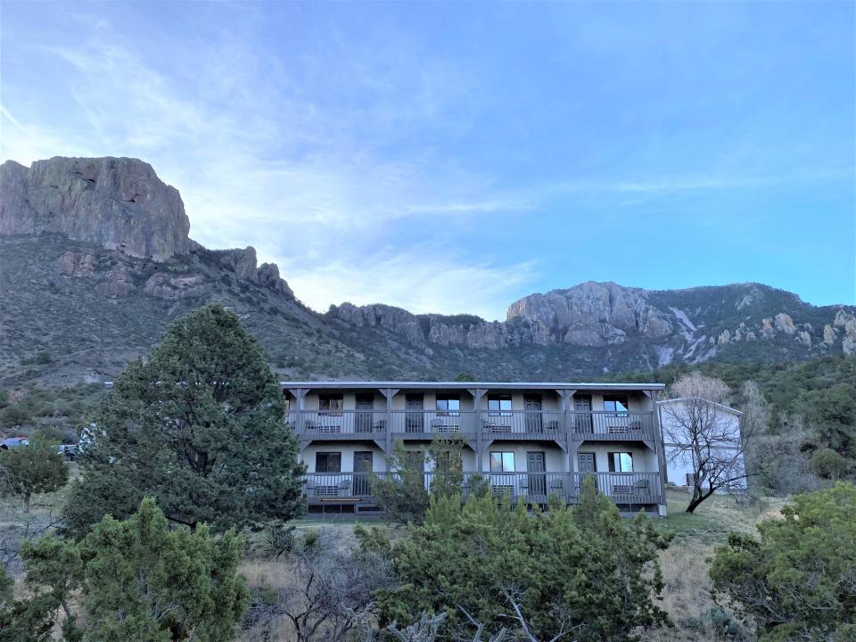
The road climbs into the heart of the Chisos Mountains, a cluster of timbered ridges and rocky peaks. After it crests at Panther Pass, we see a sign indicating mountains lions and bears claim this habitat. Our destination is Chisos Mountains Lodge at the foot of 7,550-foot Casa Grande Peak. The view from the balcony of our room overlooks the Window, a V-shaped valley entrance in the mountains. In the evening, people sit on a rock wall below the lodge to share our view of the sunset.
Chisos Mountains Lodge is a complex of 72 rooms in unassuming, low-level buildings constructed in 1964 with a desire to blend into the landscape. A restaurant, store, and the Chisos Basin Visitor Center group around the lodge; a 60-site campground is nearby.
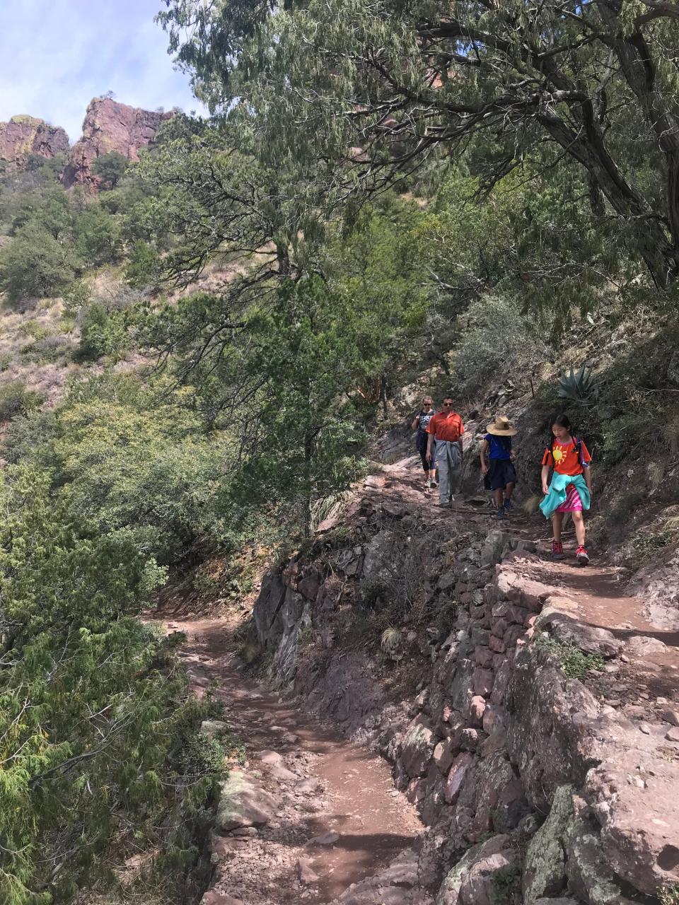
From here, visitors have easy access to a large trail network into the mountains and canyons. The Window Trail, a 5.6-mile loop, follows a dry creek and meanders through a pinyon-juniper woodland to reach the monumental notch seen from the lodge. We encounter a Mexican jay, a brilliantly blue-hued bird, on the Chisos Basin Loop Trail, a moderately easy 1.8-mile route.
The Lost Mine Trail, one of Big Bend’s most popular hikes, has an elevation gain of more than 1,000 feet. At a switchback, a black-tailed rattler soaks in sunshine. We see spectacular views of Juniper Canyon and Casa Grande Peak along the 4.8-mile out-and-back trail, especially at its farthest point, where hikers take time to sit, relax and enjoy the panorama. Layers upon layers of jagged peaks stretch into the horizon. We can’t find the mine, but then again, it is “lost,” so we head back down.
The venerated South Rim Trail is a Texas classic. Unsurpassed, it delivers endless views of the Texas Big Bend country and far into Mexico. Along the slopes, hikers move through woodlands of oaks, junipers, maples and hackberries, and, in the highest areas, ponderosa pines and Douglas firs. Coupled with connector trails, the strenuous adventure on the South Rim can take two to three days to complete, but serious hikers yearn for its challenge.
To the east
We leave Chisos Basin to explore Rio Grande Village and Boquillas Canyon on the eastern side of the national park. The locale is a premier spot for birdwatching because the Rio Grande alters the desert into a lush, green habitat. Also, it lies on major avian migration routes. More than 450 bird species have been documented at Big Bend, more than at any other national park.
The Boquillas Canyon Trail passes a quiet, sandy bank of the Rio Grande where canyon walls tower over us. The thick-layered, limestone gorge slices through the Sierra del Carmen in the state of Coahuila, Mexico.
Some park visitors take the opportunity to cross into Mexico via the Boquillas Port of Entry (passport required). The excursion involves a short ferry ride to the village of Boquillas del Carmen. U.S. currency is accepted at restaurants and shops.
To the west
Many superlatives apply to Big Bend, but without doubt, “most enchanting” describes the 30-mile Ross Maxwell Scenic Drive leading to Santa Elena Canyon. We love it so much the first day we drive it, that we return the next day as well. The magnificent scenery rolls on forever.
The drive passes two historic ranches: the Sam Nail Ranch, vestiges of a homestead dating to 1916, and the Homer Wilson Ranch, a house and remnants of livestock facilities. From Sotol Vista Overlook, we scan the vast desert prairie to a wall of sheer cliffs in the distance broken by only a small gap at the Santa Elena Canyon. Toward the road’s end, visitor exhibits in the Castolon Historic District reveal different eras. Between 1914 and 1918, an armed garrison protected settlers from bandits. The outpost evolved into a cotton-farming operation in the 1920s.
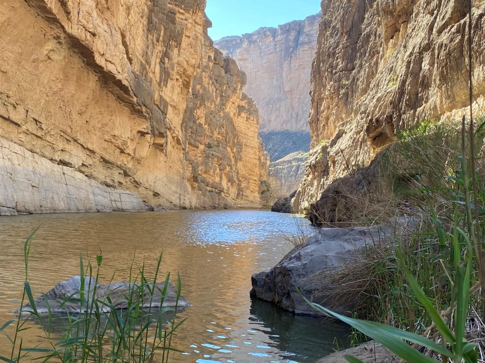
The prize at the end of the drive is Santa Elena Canyon. The trail leading to the canyon requires wading through Terlingua Creek or scrambling up a rock slide on a makeshift trail addition.
The payoff is worth it. Once inside the canyon, the bright green Rio Grande carves cliffs that rise 1,500 feet on either side. A crow’s call echoes, and leaves rustle loudly in the breeze. Huge boulders rest on the sandy floor among thick stands of cane, mesquite and tamarisk. Kayakers ply the cool water and seize their moments of good fortune.
Linda Lange and Steve Ahillen are travel writers living in Knoxville.
This article originally appeared on Knoxville News Sentinel: Travel: Discover the rugged beauty of Big Bend’s mountains and desert

