Is the tropical Atlantic on the verge of turning active?

A prolonged lack of named tropical systems in the Atlantic Ocean could come to an end as August transitions to September, AccuWeather forecasters say.
It has been nearly two months since Tropical Storm Colin came and went during the first weekend of July. Since then, environmental conditions over much of the basin this summer have been detrimental to the formation of organized tropical threats. However, as the heart of the hurricane season approaches, there are signs that tropical activity from the coast of Africa to the Caribbean could steadily increase.
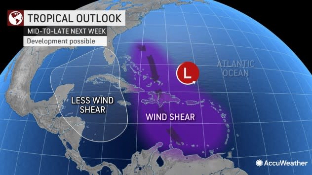
"Wind shear has dropped off in a zone from just north of the equator over the Atlantic to the Caribbean Sea this week," AccuWeather Chief On-Air Meteorologist Bernie Rayno said.
 |
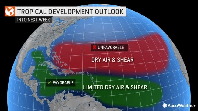
In simple terms, wind shear is a belt of stiff breezes that, when strong, can disrupt or prevent tropical development. Vast areas of wind shear, dry air and dust have been present over much of the primary development zone in the Atlantic basin this summer. A belt of strong wind shear, dry air and dust remains farther to the north over the Atlantic and will likely continue to be a deterrent for development with any system that manages to move into this zone in the days ahead.
Farther to the south, along with lower wind shear, there are pockets of moisture present. As tropical disturbances, known as tropical waves, continue to move westward in this more moist zone with light breezes, there is development potential.
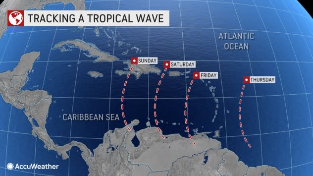
"As a tropical wave moves westward across the Caribbean through next week, wind shear may increase, for a time, then decrease," Rayno said. "The low wind shear episodes could be enough to allow slow development," Rayno said. The best chance of development of this disturbance may be over the central and western parts of the Caribbean.
 |
More than 1,000 miles to the east, one or more tropical waves will pass into another zone of low wind shear and marginally moist conditions over the central Atlantic at roughly the same time frame.
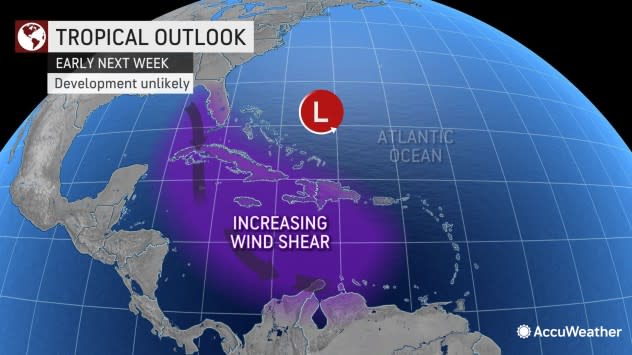
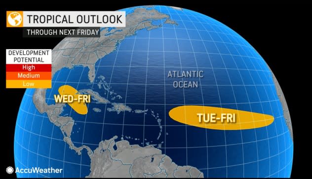
Even with low wind shear and an uptick in moisture, there is no guarantee that either the Caribbean or Atlantic disturbances will develop into a named tropical storm. Both systems have shown no signs of development thus far and are not likely to do so at the earliest until Monday. Because of the development period being so far ahead, AccuWeather meteorologists have assigned both a low chance of development.
However, because of its expected proximity to land and populated areas, the disturbance that is forecast to travel across the eastern and central Caribbean from this weekend into early next week is under a bit more scrutiny at this time.
 |
If this tropical wave fails to gain sufficient strength on its trek through the Caribbean, it is more likely to take a westerly path toward Central America and diminish later next week. On the other hand, if the system were to evolve into a depression or tropical storm or hurricane in the western Caribbean, it is more likely to take a more northwest or northward turn toward southeastern Mexico and could be a threat to the Gulf Coast region of the United States.
 |
Another zone of the Atlantic that has been quiet since Colin formed in early July extends from near the southeastern coast of the U.S. and into the north-central part of the ocean. With a front forecast to stall or move slowly along in this area next week, it would not be impossible for a non-tropical system to break away and eventually evolve into a sub-tropical or tropical feature.
Additional tropical waves will continue to move from Africa to the central Atlantic and Caribbean through September at a time when the hurricane season normally spikes. At least through next week, each successive wave will have a somewhat more moist environment than its predecessor, slowly increasing the chances of development. For that reason, and others, AccuWeather meteorologists will closely monitor new waves that move off the coast of Africa for progressively more spirited development.
 |
Once such disturbance was already showing vigor over the central Atlantic on Friday. Should this system hold together, there is a chance it strengthens enough to be a threat to the islands in the northeastern Caribbean as a tropical storm or stronger later next week.
Drought conditions over parts of Africa where tropical waves originate and move across may have been another reason, along with high wind shear, that the Atlantic has been so quiet for so long.
"Substantial drought to abnormally dry conditions have been ongoing where tropical waves get started over southern Mali, eastern Guinea, the Ivory Coast, the Ethiopian Highlands and more recently the Marrah Mountains in western Sudan," AccuWeather Senior Meteorologist Alan Reppert said.
Since the disturbances from Africa have struggled to find moisture initially, they have been weaker than usual upon reaching the Atlantic. Once over the open ocean, they encountered similar conditions due to dry air and wind shear.
While dry air and drought may linger over some key tropical wave-spawning areas in Africa, there are some signs that rain and moisture may return to portions of Ethiopia and Sudan toward the beginning of September, Reppert said. It is possible this could be enough to tip the scale and lead to some more robust tropical waves that reach the Atlantic.
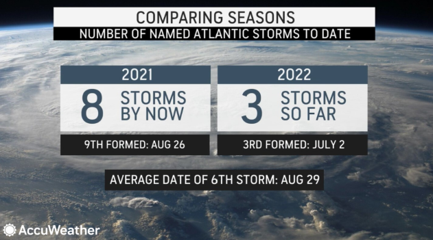
Despite just three named storms and no hurricanes at all since June 1, and the fact that there could be no named storms at all in August, it does not necessarily mean the remainder of the season will be quiet or that 2022 will be a tropical season with low risk, experts say.
There have been four years with no named storms in August since the late 1920s, but all four of those years still had damaging hurricanes. In three of those seasons, damaging and deadly hurricanes occurred after August.
Since the start of the satellite era in 1960, there were only two years, 1997 and 1961, when there were no named storms in August. While 1997 was a fairly quiet year in terms of tropical activity, 1961 was a hectic season with 12 named systems, of which eight became hurricanes, including two Category 5 monsters. One of those Category 5 storms was Esther which hit New England that September. In 1997, Hurricane Danny struck the central Gulf Coast of the U.S. in July, producing multiple fatalities and leaving $100 million in damage behind.
Before the usage of weather satellites, there may have been storms that forecasters missed over the open Atlantic. But, from the 1920s to 1960, there were only two years, 1929 and 1941, with no August storms. In late September 1929, the Great Bahamas Hurricane struck and left behind dozens of fatalities and severe damage. In October 1941, a major hurricane slammed into Florida, causing a number of fatalities and severe damage.
 |
AccuWeather meteorologists continue to warn that despite the seemingly quiet nature of the Atlantic hurricane season thus far, conditions can change quickly. It takes only one powerful hurricane or a tropical storm packing torrential rain to bring significant risk to lives and property, and turn a quiet season into a memorable one. AccuWeather's long-range team, led by Hurricane Expert Dan Kottlowski, continues to forecast multiple additional threats to coastal areas in the southeastern U.S. and its territories in the Caribbean this season.
Should the Atlantic remain without a named tropical system into early September, the record of consecutive days during the middle of a tropical season with no named systems set in 1999 could be broken. That record of 61 days in 1999 spanned June 19 through Aug. 17. However, even if the record is set this year, it would be highly unusual for there to be no named systems active somewhere over the Atlantic basin during Labor Day weekend.
The next two names on the list of tropical storms for the 2022 Atlantic season are Danielle and Earl.
Want next-level safety, ad-free? Unlock advanced, hyperlocal severe weather alerts when you subscribe to Premium+ on the AccuWeather app. AccuWeather Alerts™ are prompted by our expert meteorologists who monitor and analyze dangerous weather risks 24/7 to keep you and your family safer.
