Tropical storm forecast to form soon, could approach Florida as Cat 1 hurricane
A tropical depression in the Atlantic may approach South Florida as a Category 1 hurricane early next week, according to the National Hurricane Center.
It’s unclear if this system, tropical depression 13, or the newly minted tropical depression 14, will be the first to strengthen into Tropical Storm Laura Friday, but depression 14 has come close to forming.
The 13th depression of the season has 35 mph maximum sustained winds with higher gusts, according to the hurricane center’s advisory at 8 a.m. Friday, and is about 255 miles east of the northern Leeward Islands. It’s headed west-northwest at 21 mph.
A tropical storm watch was issued early Friday for the southeastern Bahamas and Turks and Caicos.
The latest track shows tropical depression 13 strengthening into a tropical storm on Friday night before passing north of the Leeward Islands, Puerto Rico and Hispaniola over the weekend. Sometime Sunday night, after the storm has crossed the Bahamas, it could strengthen into a Category 1 hurricane before approaching South Florida.
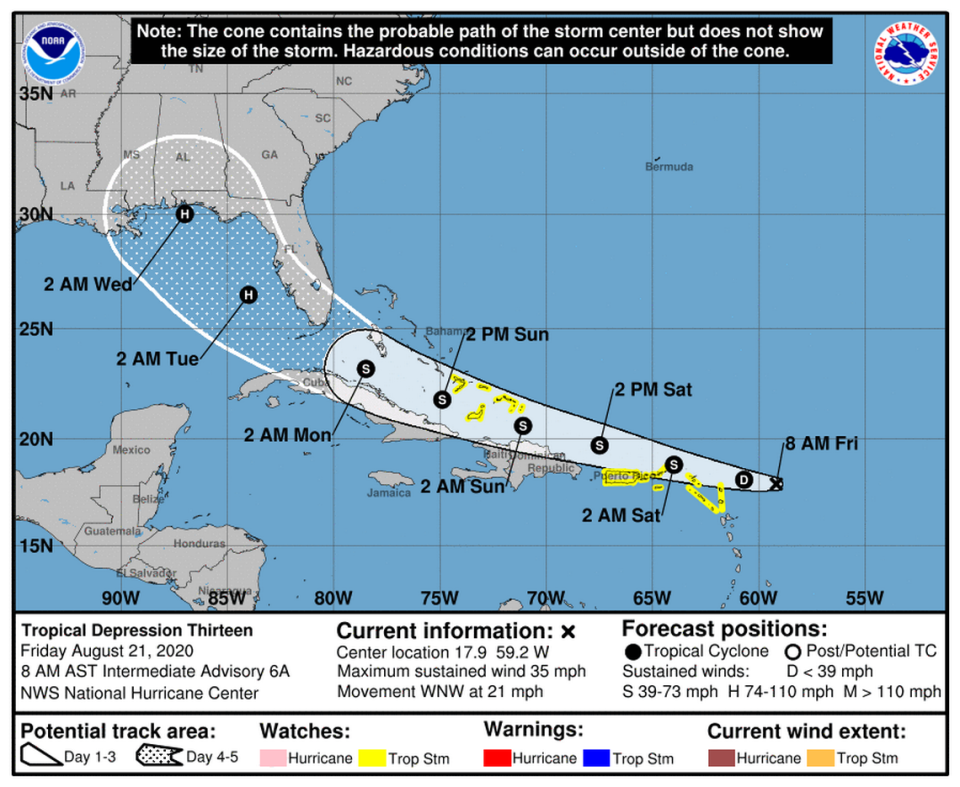
Forecasters are cautioning, however, that its long-range track and intensity forecasts “are more uncertain than usual since the system could move over portions of the Greater Antilles this weekend.”
Its future path and strength will depend on how it interacts with the high mountains of Hispaniola.
“If the depression moves on the south side of the guidance envelope, further strengthening would be limited due to land interaction. Conversely, if the system gains more latitude and moves north of these highly topographic islands, it could have the opportunity for more significant intensification,” forecasters wrote.
Tropical Depression 14 formed
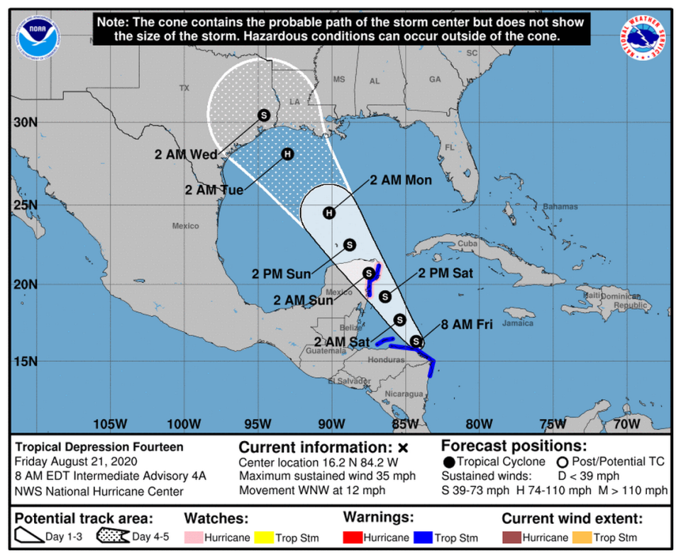
Another tropical depression also formed Thursday morning and is close to becoming a tropical storm, the National Hurricane Center said. It was about 160 miles east of Isla Roatan, Honduras, with 35 mph winds as of the 8 a.m. Friday update. It is traveling 12 mph.
If tropical depression 14 grows into a tropical storm after tropical depression 13 strengthens into Laura, it would be named Marco. On Friday morning, it was just off the northeastern coast of Honduras.
The system is predicted to scrape northern Nicaragua and northeastern Honduras as a tropical storm on Friday and cross the Yucatan Peninsula on Saturday “at or near hurricane strength” before heading through the Gulf and toward Texas and Louisiana on Tuesday.
Jamaica and northern Nicaragua could see one to two inches of rain as a result of this system, forecasters said. Portions of Honduras could see two to four inches of rain through Saturday.
Watches/Warnings
Tropical storm watches were issued for the southeastern Bahamas, the Turks and Caicos islands, Puerto Rico, Vieques, Culebra, the U.S. and British Virgin Islands, St. Martin and St. Barthelemy. Tropical storm watches remained in effect for St. Maarten, Antigua, Barbuda, St. Kitts, Nevis, Anguilla, Saba and St. Eustatius.
Tropical storm conditions, including heavy rainfall, will be possible across portions of the northern Leeward Islands by Friday night and possibly in the Virgin Islands and Puerto Rico through the weekend, according to the hurricane center.
The hurricane center says those areas could see one to three inches of rain, with five inches in some spots, through Sunday.
A hurricane and tropical storm warning have been put into effect for Punta Herrero to Cancun, Mexico. The tropical storm warnings are in effect for the coast of Honduras from the Honduras/Nicaragua border to Punta Castilla and for the Bay Islands of Honduras. The coast of Nicaragua from Puerto Cabezas northward is also under a tropical storm warning.
What about the other wave in the Atlantic?
The third wave is producing disorganized showers and thunderstorms near the Africa coast. Forecasters said “some slow development is possible through the weekend” as it moves west-northwest across the eastern tropical Atlantic. They gave it a 20% chance of organizing into a tropical cyclone in the next two days and a 50% chance of organizing in the next five days.
The next storm name on the list is Nana.

