Tropical Storm Lee strengthens on way to becoming powerful hurricane. What track shows
UPDATE: Lee is now a Category 1 hurricane in the Atlantic. By the weekend, it could be Category 4
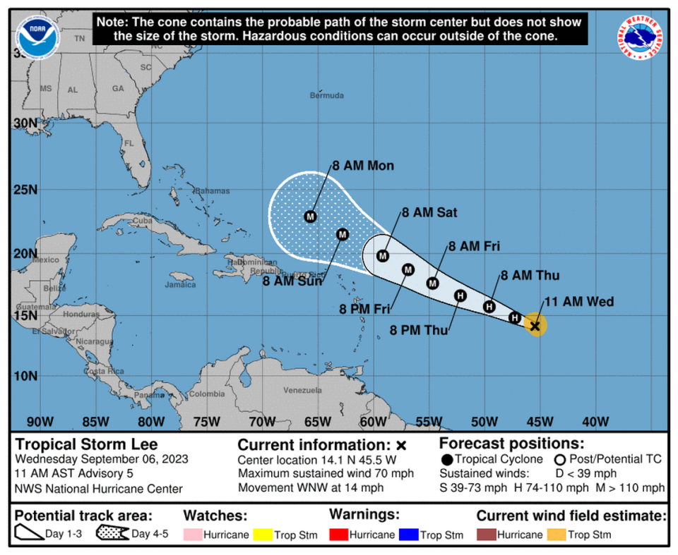
Tropical Storm Lee was near hurricane strength Wednesday morning as it trekked west across the Atlantic and on track to strengthen into a powerful Category 4 hurricane over the weekend.
The latest forecast track by the National Hurricane Center steers the storm in the general direction of the east coast, with the potential for a northern scrape of the Leeward and Virgin Islands over the weekend.
But the hurricane center’s cone only forecasts five days out. And most longer-range storm models suggest that the storm could bend north before it gets too close to Florida or the Bahamas, potentially setting Bermuda in the crosshairs. But it’s too early to stay if those projections will stick.
“Stay alert. Storms forecast to be this strong take a longer time to make a marked turn. Hoping models are correct and keep the system away from any land,” WSVN lead meteorologist Phil Ferro posted Wednesday on X, the social media site formerly known as Twitter.
But as of Wednesday’s 11 a.m. update, forecasters at the hurricane center focused on the immediate future of the storm, which was set to become a major hurricane with 150 mph winds by Saturday.
As of 11 a.m. Wednesday, Lee had strengthened, with maximum sustained winds of 70 mph. The storm was traveling west-northwest at 14 mph.
Lee was forecast to hit hurricane strength later Wednesday, according to the hurricane center.
Storm models were in close agreement for the initial few days of the storm’s track, the hurricane center said. But it noted that the average error range was wide enough that those in the Leeward Islands should still watch the storm.
Tuesday evening’s update nudged the track slightly to the northeast to better reflect the models, forecasters said. For now, they wrote, Lee appeared to be on a steady west-northwest track, thanks to a ridge to its north that’s expected to stay in place through the weekend.
READ MORE: Tropical Storm Lee, two other systems are roaming the Atlantic. What the forecast says
Forecasters said the storm is likely to rapidly intensify later this week in the low shear and record warm waters near the Lesser Antilles that they noted “would look more in place in the Gulf of Mexico” in a Tuesday discussion.
By Wednesday, although the hurricane center’s forecast cone had not yet reached the east coast, early models continued to show a bend north in Lee’s future.
Compare my tweet from Labor Day Monday to this one to see trends in the ensemble forecasts from the European ECMWF and American GFS. They show a greater consensus that #Lee will pass north of the northeastern Caribbean and recurve into the North Atlantic. Bermuda & NE in play. pic.twitter.com/laqJS3ISGT
— John Morales (@JohnMoralesTV) September 6, 2023
John Morales, hurricane specialist for NBC6, posted side-by-side images of two major storm models, the European model and the Global Forecast System, from Tuesday and Wednesday. They showed an even stronger trend toward a northern turn.
“They show a greater consensus that #Lee will pass north of the northeastern Caribbean and recurve into the North Atlantic,” he posted.

