Puerto Rico, US Virgin Islands on alert as Fiona strengthens


Tropical storm watches were put into effect for Puerto Rico and the U.S. Virgin Islands late Thursday afternoon, adding to a slew of warnings and watches that were already in effect. Fiona lost some wind intensity early with its sustained winds dropping to 50 mph and higher gusts, according to the National Hurricane Center (NHC).
As of 8 a.m. Friday, Fiona was located about 175 miles east of the island of Guadeloupe and was heading westward at a speed of 15 mph. Tropical-storm-force winds extend outward up to 125 miles, the NHC said.
Tropical Storm Fiona developed east of the Leeward Islands late Wednesday evening, according to the NHC. AccuWeather forecasters had been watching a disturbance in the area this week due to its potential for development, and on Wednesday, the system became more organized.
Tropical storm watches were upgraded to warnings in parts of the Leeward Islands Thursday. The government of Antigua and Barbuda issued the warnings for Antigua, Barbuda, St. Kitts, Nevis, Montserrat, and Anguilla, the NHC said. Elsewhere, the Netherlands government issued a warning for the islands of Saba and St. Eustatius, while the government of St. Maarten declared a warning as well.
The French government declared a tropical storm watch for the islands of Guadeloupe, St. Barthelemy, and St. Martin.
Tropical storm watches were issued for the British Virgin Islands, the U.S. Virgin Islands and Puerto Rico, including Vieques and Culebra, Thursday evening.
 |
Fiona became the sixth named storm of the 2022 Atlantic hurricane season on Wednesday night, about 12 hours after it was labeled as a tropical depression.
"There will be a brief window, into Friday, where Fiona may gain some more strength as a tropical storm, despite disruptive wind shear," AccuWeather Meteorologist Rob Richards said, "But, beyond Friday, interaction with the progressively larger islands and taller mountains over the northern Caribbean will likely lead to weakening or at least cause strengthening to cease."
 |
There are some pockets of dry air in Fiona's path, but it is much less than the dry conditions farther east in the Atlantic basin.
Tropical Storm Fiona is forecast to move generally westward through Saturday which will take the storm across the northern islands of the Caribbean. The outer bands of the tropical system are likely to reach the Leeward Islands on Friday morning.
The most widespread impact of this tropical system will be drenching downpours. Rainfall amounts of 4-8 inches, with an AccuWeather StormMax™ of 18 inches, could bring localized flooding from the islands of Guadeloupe and Antigua, through the British and U.S. Virgin Islands and Puerto Rico to the Dominican Republic.
 |
As Fiona strengthens further, wind gusts will increase up to 60 mph across the same islands.
Due to the risk that the rain and wind pose across the region, this storm has been rated as less than one on the AccuWeather RealImpact™ Scale for Hurricanes.
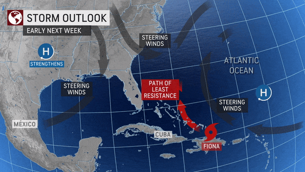
The fate of Tropical Storm Fiona after Friday will be heavily dictated by the environment that the tropical feature will be moving into over the central Caribbean islands.
 |
"There is a plethora of strong wind shear across the Caribbean islands. This combined, with the friction of the tropical system passing over the mountainous islands, is expected to help the system lose wind intensity over the weekend," AccuWeather Senior Meteorologist Adam Douty said.
Even with lesser wind speeds, Fiona could still be impactful to Puerto Rico, Hispaniola, eastern Cuba and the southern Bahamas. Heavy, tropical rainfall and gusty winds will be the most likely impacts to land, along with rough seas in nearby waters.
 |
AccuWeather forecasters expect the tropical feature to take a turn more to the north once it reaches the Bahamas due to strong wind shear in the Gulf of Mexico and nearby steering winds. As such, initial indications are that the feature could miss the United States. However, since any direct interaction from Fiona in the U.S. is more than a week away, it is possible that weather patterns may shift. For this reason, interests along the East Coast of the U.S. and Bermuda should continue to monitor Fiona's progress.
Even without an organized storm forecast to impact the eastern U.S. in the coming week, tropical moisture is still expected to play a role in weather conditions taking shape across parts of the country this week.
 |
"A front will stall along the Gulf Coast, helping to produce thunderstorms across the Florida Peninsula. A flow of tropical moisture from the Caribbean and Gulf toward this front will further enhance thunderstorms with heavy rain," Douty said.
Drenching thunderstorms for the second half of the week could quickly bring as much as 1-2 inches of rain in a short amount of time. While the soil across much of Florida is equipped to handle heavier-than-normal downpours, water could start ponding in more developed or paved locations such as cities, especially in low-lying areas.
AccuWeather forecasters say that motorists should be particularly alert for heavy downpours that could bring reduced visibility and associated travel delays.
 |
Depending on the tropical system's track and should any of the tropical moisture from Fiona survive the strong winds of the Caribbean, there could be another round of tropical downpours in parts of Florida next week. A second dose of heavy rain in just a few days could bring an increased risk for flooding.
The peak of hurricane season came and went over the weekend with little actual cyclonic activity over the Atlantic basin, which has been notably dormant this year after two years of nearly constant activity, particularly in the middle parts of the seasons.
On Sept. 10, the aforementioned statistical peak of the Atlantic season, the only hurricane to speak of was Earl, which, after reaching Category 2 force earlier in the week, was speeding over the North Atlantic and posed virtually no direct threat to land. Earl was just the fifth named storm of the 2022 Atlantic hurricane season and, at one point about 800 miles away from Cape Hatteras, was the closest any hurricane this season came to the United States mainland.
Nearly two-and-a-half months through the 2022 hurricane season, not a single hurricane has come within striking distance of the East Coast or Gulf Coast.
 |
Based on the below-average number of storms so far this season, long-range forecasts and the advancing stage of the current season, AccuWeather forecasters revised their overall forecast for named storms to around 12 on Tuesday. This means forecasters expect seven additional storms to form before the end of the season. In addition, they revised the number of expected hurricanes to four to six, which means of those seven storms, as many as two to four could become hurricanes this year.
Want next-level safety, ad-free? Unlock advanced, hyperlocal severe weather alerts when you subscribe to Premium+ on the AccuWeather app. AccuWeather Alerts™ are prompted by our expert meteorologists who monitor and analyze dangerous weather risks 24/7 to keep you and your family safer.
