Tropical Storm Phillippe forms as Tropical Storm Ophelia moves into Virginia
Tropical Storm Ophelia is making its way north along the Mid-Atlantic, while Tropical Storm Phillippe formed Saturday evening in the Atlantic.
As of the latest update, the National Hurricane Center said Ophelia was moving north at 13 mph over eastern North Carolina. Tropical storm conditions continue along the coast and inland. Maximum sustained winds have fallen to 45 mph with higher gusts.
Ophelia is expected to continue to move north through Virginia and the Delmarva Peninsula into Sunday, bringing heavy rain, flooding and tropical storm conditions to the region.
The impact to Florida will largely be through dangerous rip currents. The National Weather Service said a high rip current risk will be in effect for Southeast Georgia and Northeast Florida beaches through the night.
Elsewhere in the Atlantic, Phillippe formed as it moved west. Maximum sustained winds are 40 mph, and the system is expected to pick up speed over the next few days.
At this time, Phillippe is forecast to remain in the Atlantic and turn north before coming close to the U.S. mainland. It is expected to remain below hurricane strength over the next week.
The next named storm would be Rina.
The NHC is monitoring two more tropical waves in the eastern Atlantic.
Here's the latest update from the NHC as of 5 p.m.:
Tropical Storm Ophelia

Special note on the NHC cone: The forecast track shows the most likely path of the center of the storm. It does not illustrate the full width of the storm or its impacts, and the center of the storm is likely to travel outside the cone up to 33% of the time.
Location: 50 miles south of Richmond, Virginia and 160 miles southwest of Ocean City, Maryland
Maximum wind speed: 40 mph
Direction: north at 12 mph
As of 5 p.m., the center of Tropical Storm Ophelia was located near latitude 36.8 North, longitude 77.3 West. Ophelia is moving north near 12 mph. A gradual turn to the northeast is expected by Sunday.
On the forecast track, the center of Ophelia is expected to continue moving over southeastern Virginia tonight, and then move over the Delmarva Peninsula by Sunday.
Maximum sustained winds have decreased to near 40 mph with higher gusts. Additional weakening is expected, and Ophelia is likely to become a post-tropical cyclone Sunday.
Tropical storm-force winds extend outward up to 310 miles from the center. A WeatherFlow station in Palmico Sound recently reported a sustained wind of 37 mph with a gust up to 43 mph.
The estimated minimum central pressure is 997 mb.
Watches and warnings issued for Tropical Storm Ophelia
For an explanation of what the watches and warning mean, scroll to the bottom of this story.
Storm surge warning:
Hatteras Inlet, North Carolina to Duck
Colonial Beach, Virginia to Suffolk
Tropical storm warning:
Okracoke Inlet, North Carolina to Fenwick Island, Delaware
Albemarle and Pamlico sounds
Tidal Potomac south of Cobb Island
Chesapeake Bay south of North Beach
What impact could Tropical Storm Ophelia have and what areas could be affected?
Wind: Tropical storm conditions are affecting portions of the coast of North Carolina and southeastern Virginia within the warning area and will continue spreading northward through the evening.
Storm surge: The combination of the dangerous storm surge and the tide will cause normally dry areas near the coast to be flooded by rising waters moving inland from the shoreline. The water could reach the following heights above ground somewhere in the indicated areas if the peak surge occurs at the right time of high tide:
Hatteras Inlet, North Carolina to Duck: 2-4 feet
James and York rivers: 2-4 feet
Rappahannock River: 2-4 feet
Lower Potomac River: 2-4 feet
Duck, North Carolina to Manasquan Inlet, New Jersey: 1-3 feet
Upper Chesapeake Bay: 1-3 feet
Delaware Bay: 1-3 feet
Surf City, North Carolina to Hatteras Inlet: 1-2 feet
Neuse and Bay rivers: 1-2 feet
Pamlico and Pungo rivers: 1-2 feet
Albemarle and Pamlico Sound: 1-2 feet
The deepest water will occur along the immediate coast in areas of onshore winds, where the surge will be accompanied by dangerous waves. Surge-related flooding depends on the relative timing of the surge and tidal cycle, and can vary greatly over short distances. For information specific to your area, please see products issued by your local National Weather Service forecast office.
Rainfall: Ophelia is expected to produce the following rainfall through Sunday night:
Portions of the Mid-Atlantic from north central North Carolina through New Jersey: 1-3 inches with isolated higher totals up to 5 inches
Across southern New York through southern New England: 1-3 inches
This rainfall may produce locally considerable flash, urban and small-stream flooding impact, particularly across the Mid-Atlantic region from North Carolina to New Jersey. Isolated river flooding is possible in areas with heavier rainfall.
Tornadoes: A tornado or two may occur today over parts of the Mid-Atlantic coast.
Surf: Swells generated by Ophelia will affect much of the East Coast of the United States through the weekend. These swells are likely to cause life-threatening surf and rip current conditions. Please consult products from your local weather office.
Tropical Storm Phillippe forms

Location: 1,045 miles west of Cabo Verde Islands
Maximum wind speed: 40 mph
Direction: west at 14 mph
At 5 p.m., the center of Tropical Storm Phillippe was near latitude 15.6 North, longitude 39.7 West. Phillippe is moving west near 14 mph. A continued westward motion at a slightly slower forward speed is expected into early next week.
Maximum sustained winds are near 40 mph with higher gusts. Very gradual strengthening is expected during the next several days.
The estimated minimum central pressure is 1,005 mb.
What else is out there and how likely are they to strengthen?

Tropical wave 1: A tropical wave has recently moved off the west coast of Africa and is producing a broad area of disorganized showers and thunderstorms.
Environmental conditions are expected to be conducive for some gradual development of this system in the middle or late next week while it moves west across the eastern and central tropical Atlantic.
Formation chance through 48 hours: low, near 0 percent.
Formation chance through seven days: low, 20 percent.
Tropical wave 2: A Caribbean Sea tropical wave is north of the British Virgin Islands, moving west about 11 mph. Isolated moderate rainfall is within 180 nm on either side of the tropical wave. Exact location: 64W/65W, from 22N southward.
Who is likely to be impacted?
The Mid-Atlantic from North Carolina through New York are expected to feel affects from Tropical Storm Ophelia through the weekend.
It's too early at this time to determine if there will be any impact to the U.S. from the system in the Atlantic or the tropical waves.
Forecasters urge all residents to continue monitoring the tropics and to always be prepared.
Weather watches and warnings issued in Florida
When is the Atlantic hurricane season?
The Atlantic hurricane season runs from June 1 through Nov. 30.
When is the peak of hurricane season?
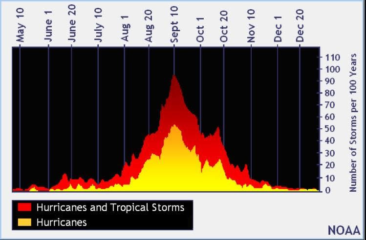
The peak of the season is Sept. 10, with the most activity happening between mid-August and mid-October, according to the Hurricane Center.
Tropical forecast over the next seven days
Excessive rainfall forecast
What's out there?
Systems currently being monitored by the National Hurricane Center.

Noaa
Embedded content: https://www.nhc.noaa.gov/xgtwo/two_atl_0d0.png?052051
What do the watches and warnings from NHC mean?
What is storm surge? Graphics explain the deadly weather event
Hurricane warning: A hurricane warning means that hurricane conditions are expected somewhere within the warning area. A warning is typically issued 36 hours before the anticipated first occurrence of tropical-storm-force winds, conditions that make outside preparations difficult or dangerous. Preparations to protect life and property should be rushed to completion.
Hurricane watch: A hurricane watch means that hurricane conditions are possible within the watch area. A watch is typically issued 48 hours before the anticipated first occurrence of tropical-storm-force winds, conditions that make outside preparations difficult or dangerous.
Tropical storm warning: A tropical storm warning means that tropical storm conditions are expected somewhere within the warning area within 36 hours.
Tropical storm watch: An announcement that sustained winds of 39 to 73 mph are possible within the specified area within 48 hours in association with a tropical, subtropical, or post-tropical cyclone.
Storm surge warning: A storm surge warning means there is a danger of life-threatening inundation, from rising water moving inland from the coastline, in the indicated locations. This is a life-threatening situation. Persons located within these areas should take all necessary actions to protect life and property from rising water and the potential for other dangerous conditions. Follow evacuation and other instructions from local officials.
Storm surge watch: A storm surge watch means there is a possibility of life-threatening inundation, from rising water moving inland from the coastline, in the indicated locations during the next 48 hours
What's next?
We will continue to update our tropical weather coverage daily. Download your local site's app to ensure you're always connected to the news. And look at our special subscription offers here.
This article originally appeared on Treasure Coast Newspapers: NHC tracking Tropical Storm Ophelia, Phillippe, tropical waves

