Tropical depression in Gulf to bring heavy rain to Bradenton area this weekend
The 2023 hurricane season has begun and a low-pressure system is already stirring up a fuss in the Gulf of Mexico, most likely bringing a lot of rain to the Bradenton area.
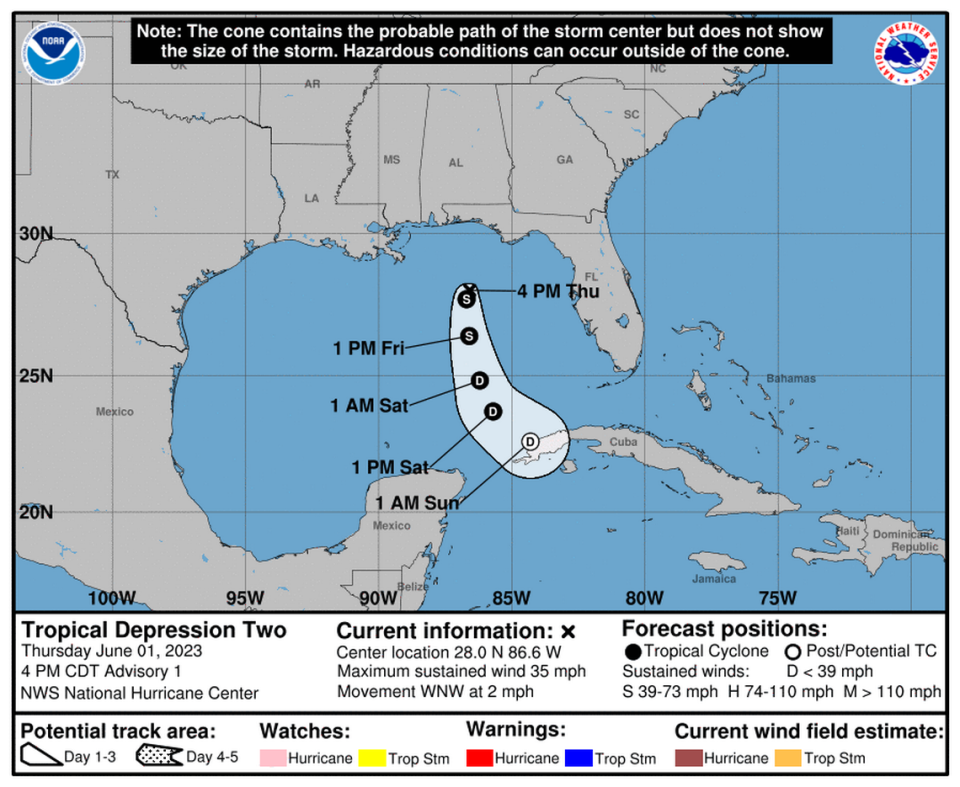
The National Hurricane Center said the system had strengthened Tropical Depression 2 status by 4:19 p.m. Thursday. It had winds of 35 mph and was moving northwest.
A lot of rain is in store for Florida as the system hangs out over the Gulf over the next couple of days, National Weather Service Tampa meteorologist Nicole Carlisle told the Bradenton Herald on Thursday.
Bradenton residents should prepare for heavy rain and thunderstorm activity through Saturday.
The main threat is heavy rainfall and street flooding.
The Weather Service has not yet issued any watches or warnings for the area, and the Hurricane Center said no coastal watches or warnings were anticipated.
The storm is expected to remain offshore and move slowly south on Friday.
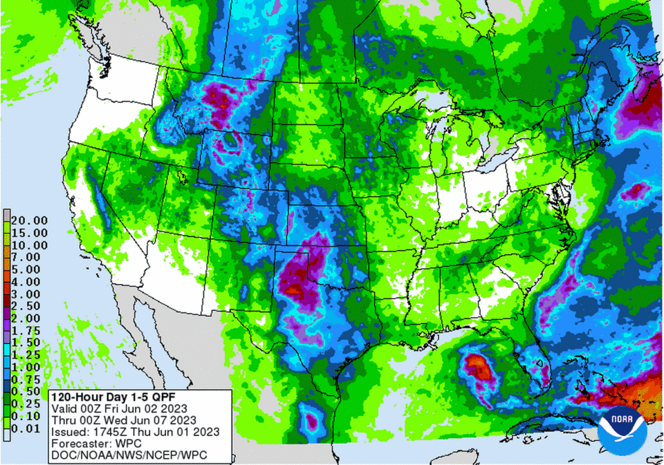
“Rainfall amounts of 1 to 3 inches with localized higher amounts up to 6 inches are possible through Saturday across portions of the central and southern Florida Peninsula,” the Hurricane Center said. “This rainfall is not directly related to Tropical Depression Two.”
Rain chances will gradually decrease through the weekend and the system drifts southeast toward Cuba and weakens.
Heavy rainfall across our area, potentially causing localized street flooding, is the main concern with this system through Saturday, regardless of if it develops or not. #FLwx https://t.co/GJRqxsrvAl
— NWS Tampa Bay (@NWSTampaBay) June 1, 2023
On Friday, there is a 40-50% chance of rain and thunderstorms, mainly later in the day and evening.
Saturday’s rain chances are highest between 2 p.m. and 8 p.m.
On Sunday, there is only a 3% chance of rain in the forecast.
Residents should be on the lookout for minor flooding in some areas. However, Carlisle said that while it will rain and storm, she doesn’t expect it to be widespread or severe.
Aside from the damper the storm my put on your weekend plans, it’s really beneficial for Florida, which has been suffering from a drought.
In particular, Manatee County is experiencing a severe drought, according to the website drought.gov.
“We’re in a drought. We’re starting to transition out of the dry season and into the wet season,” said Carlisle. “Even compared to a week ago, the drought has improved and it’ll continue into the summer months.”
Bradenton weather forecast
Friday: Scattered showers and thunderstorms between 11 a.m. and 2 p.m., then showers likely and possibly a thunderstorm after 2p.m. Partly sunny, with a high near 89. East northeast wind around 8 mph. Chance of precipitation is 70%. New rainfall amounts between a tenth and quarter of an inch, except higher amounts possible in thunderstorms.
Friday night: Showers likely and possibly a thunderstorm before 8pm, then scattered showers and thunderstorms between 8 p.m. and 2 a.m. Mostly cloudy, with a low around 71. East northeast wind around 8 mph. Chance of precipitation is 60%.
Saturday: Scattered showers and thunderstorms, mainly after 2 p.m. Mostly sunny, with a high near 89. Northeast wind around 9 mph. Chance of precipitation is 40%.
Saturday night: Scattered showers and thunderstorms, mainly before 8 p.m. Partly cloudy, with a low around 71. Northeast wind around 8 mph. Chance of precipitation is 30%.
Sunday: Isolated showers and thunderstorms after 2 p.m. Sunny, with a high near 89. Northeast wind 7 to 11 mph becoming north northwest in the afternoon. Chance of precipitation is 20%.
Sunday night: Isolated showers and thunderstorms before 8 p.m. Mostly clear, with a low around 71. Northeast wind around 10 mph. Chance of precipitation is 10%.
Monday: Isolated showers and thunderstorms after 2 p.m. Sunny, with a high near 90. Northeast wind 8 to 11 mph becoming north northwest in the afternoon. Chance of precipitation is 20%.
Monday night: Isolated showers and thunderstorms before 8 p.m. Mostly clear, with a low around 71. Chance of precipitation is 10%
Hurricane season is here! Residents should stock a disaster supply kit that lasts the household,
including pets, for at least 7+ days.
Get tax-free supplies, including household consumable items like toilet paper, until 6/9.
List of qualifying items - https://t.co/ZmnZ7i87wz. pic.twitter.com/IJ5YnD78V8— Manatee County Government Public Safety Department (@MCGPublicSafety) June 1, 2023

