Paulette to become powerful cyclone, while Teddy strengthens and Vicky refuses to weaken
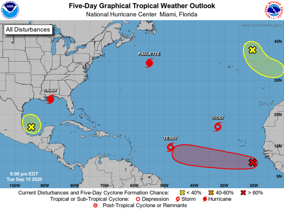
Hurricane Sally is on the verge of becoming a powerful extratropical cyclone. Tropical Storms Teddy and Vicky are out and not getting any weaker while three other tropical disturbances are being tracked.
An area of low pressure, described as a low-latitude tropical wave, was a few hundred miles south-southeast of the Cabo Verde Islands as of 8 p.m. Tuesday, according to the National Hurricane Center.
The system’s shower and thunderstorm activity become more concentrated overnight and a tropical depression is expected to form during the next few days as the system moves west at 10 to 15 mph.
Forecasters say it has a 50 percent chance of forming into a tropical cyclone in the next 48 hours and a 70 percent in the next five days.
As for the new disturbance, its a non-tropical area of low pressure located over the far northeastern Atlantic, several hundred miles northeast of the Azores. It has a 10 to 20 percent chance of formation in the next 2 to 5 days.
“This system could acquire some subtropical characteristics while it moves southeastward at about 10 mph during the next couple of days,” forecasters wrote.
It’s peak hurricane season and we’re about to run out of names. What happens then?
Will Florida feel Hurricane Sally?
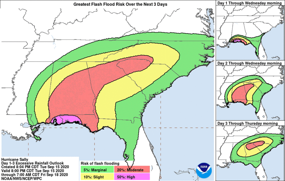
Hurricane Sally’s potential landfall point keeps shifting east, but forecasters warned that the real danger of this storm would likely be the rain, which will affect areas far outside the cone. Some spots could see up to 30 inches of rain as Sally creeps by.
“Historic, life-threatening flash flooding is likely. In addition, this rainfall will lead to widespread moderate to major flooding on area rivers,” forecasters said.
The storm is expected to make landfall early Wednesday morning.
A storm surge warning has been extended and now effects from the Okaloosa/Walton County Line to the Walton/Bay County Line Florida. The hurricane warning has also been extended east of Navarre Florida to the Okaloosa/Walton County line Florida.
The storm surge warning has been discontinued between the mouth of the Pearl River and the Mississippi/Alabama border, but Mobile Bay is still under the warning.
A tropical storm warning is also in effect from East of Navarre, Florida to Indian Pass Florida and from the Mouth of the Pearl River westward to Grand Isle Louisiana.
Early Tuesday morning, Sally dropped back to a Category 1 storm and slowed to almost a dead stop at 2 mph.
As of 11 pm. Tuesday, Sally was about 75 miles south of Mobile, Alabama and had 80 mph maximum winds. The storm’s hurricane-force-winds extended up to 40 miles from its center and tropical-storm-force winds extended up to 125 miles.
Winds and heavy rain began pelting areas of the Florida Panhandle and Alabama Tuesday morning, and swells generated by Sally are also forecast to cause life-threatening surf and rip current conditions from the Florida Big Bend west to southeastern Louisiana during the next couple of days.
On Monday evening, Gov. Ron DeSantis declared a state of emergency for Escambia and Santa Rosa counties.
Forecasters are also monitoring a broad area of low pressure over the southwestern Gulf of Mexico that is producing a limited amount of showers and thunderstorms late Tuesday. It has a low 10 to 20 percent of development in the next two to five days.
Listen to today's top stories from the Miami Herald:
Subscribe: Apple Podcasts | Spotify | Amazon Alexa | Google Assistant | More options
Hurricane Paulette left Bermuda. Where is Tropical Storm Teddy going?
Hurricane Paulette has long left Bermuda behind and is continuing to maintain its Category 3 hurricane strength as it accelerates northeastward into the open ocean. Swells generated by Paulette, however, are forecast to continue affecting portions of Bermuda, the Bahamas, the Greater Antilles and the east coast of the United States through Tuesday night, with life-threatening surf and rip current conditions possible.
Paulette is forecast to begin rapidly weakening Wednesday evening, slow down and turn southeast by late Thursday.
As for Tropical Storm Teddy, its maximum sustained winds have increased to near 65 mph with higher gusts and will likely become a hurricane later Tuesday, according to the hurricane center. It’s expected to become a “large and powerful hurricane” over the central Atlantic ocean in a few days and may be a higher end Category 3 by the time it nears Bermuda Sunday, according to its forecast track.

“The model spread is still much lower than normal, and confidence in the track forecast is fairly high,” forecasters wrote.
Large swells generated by Tropical Storm Teddy are expected to reach the Lesser Antilles and the northeastern coast of South America Wednesday and may cause life-threatening surf and rip current conditions, according to the hurricane center.
Tropical Storm Vicky
Tropical Storm Vicky is forecast to weaken back into a tropical depression in the next couple of days and was about 500 miles northwest of the Cabo Verde Islands early Tuesday, according to the hurricane center. Forecasters say it will likely weaken into a remnant low by Wednesday.

