Hurricane and storm surge watches issued for Florida Gulf coast ahead of Idalia
Hurricane, tropical storm and storm surge watches were issued for Florida’s west coast ahead of a potential mid-week landfall from Idalia, now a tropical storm. The new watches cover nearly the entire west coast, from Cape San Blas in Gulf County down to the Florida Keys.
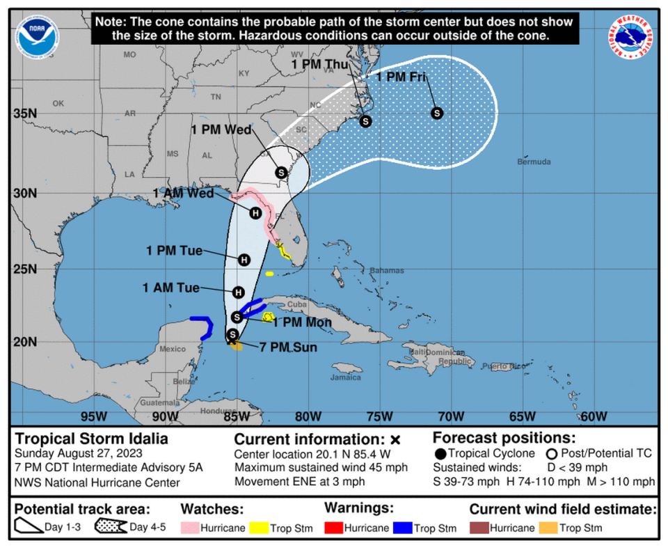
Sunday night, the National Hurricane Center called for Tropical Storm Idalia to strike Florida’s Big Bend area as a Category 2 hurricane Wednesday, bringing 100 mph winds and up to 11 feet of storm surge, but warned it could rapidly intensify into something stronger — and the when and where of its landfall could still shift.
Gov. Ron DeSantis has issued a state of emergency declaration of 33 counties in Florida over Tropical Storm Idalia, and the state has already begun preparing for landfall by staging rescue supplies and pre-positioning line workers for power companies.
While early storm models were in good agreement on a landfall near Florida’s Big Bend region late Tuesday to early Wednesday, the hurricane center launched multiple hurricane hunter flights on Sunday to dial in on the forecast, which is all but guaranteed to change this far out from landfall.
“If you’re anywhere along the western Florida peninsula, Fort Myers northward to the Panhandle, you’ve really got to be paying attention,” said Jamie Rhome, deputy director of the National Hurricane Center, in a virtual morning update. “This system can and will change.”
The cone of uncertainty used by the hurricane center does not show where the impacts could occur, it shows a best guess at where the center of the storm could go, which means areas far outside of the cone still see destructive winds, rain and storm surge.
In a Sunday news conference from the state’s Emergency Operations Center, DeSantis addressed similar concerns. He said the forecast models are more aligned than they were for Hurricane Ian last year, but said that even if people are outside of the forecast “cone,” they could see impacts from Idalia and should be prepared.
“Floridians along our Gulf Coast should be vigilant even if you’re currently outside the cone,” DeSantis said.
Investigating Idalia
NOAA’s Hurricane Hunters and the Air Force Reserve had seven separate flights scheduled Sunday to check out Idalia. The data they collect will help forecasters at the National Hurricane Center put a pin in the system’s center swirl, which will vastly improve the storm models and help lead to a more accurate prediction.
What those hurricane spaghetti models all over social media actually mean
As of Sunday evening, the hurricane center said the storm was expected to remain in place for about a day before heading into the Gulf. From there, its predicted path skirts some storm-eating wind shear and plows directly into record-hot, storm-fueling waters, raising the chances the system could rapidly intensify into a much stronger hurricane.
The latest forecast included an uptick in strength, to a Category 2 hurricane with 100 mph sustained winds at landfall.
But warm Gulf waters could power Idalia into a Category 3 or even stronger storm before landfall. The hurricane center warned that fast development was a “notable risk” and it made it difficult to predict how strong Idalia could be before landfall.
“There is considerable spread in the model intensity guidance, ranging from minimal to major hurricane status before landfall on the northeast Gulf coast,” forecasters wrote in the 5 p.m. discussion.
For the last few forecast advisories, the hurricane center’s track has windshield wipered east and west, a nod to all of the models doing the same. That will continue to happen as the storm closes in, which means all Floridians along the west coast should be watching the storm, not just those in the Big Bend area.
The latest forecast moved the track to the east again, a pattern that’s continued since Saturday.
Generally, forecasters said, a stronger storm is more likely to lean west, while a weaker storm could make landfall earlier on a more easterly track.
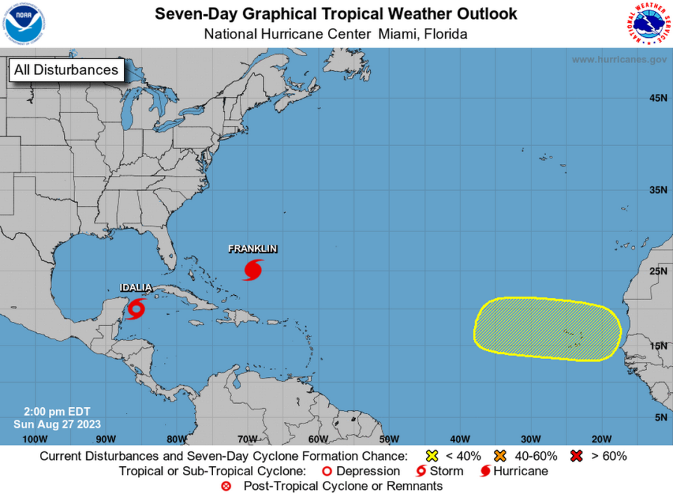
As of the 8 p.m. advisory, Idalia was about 95 miles east-southeast of Cozumel, Mexico with maximum sustained winds of 45 mph, headed northeast at 3 mph. Tropical storm force winds extended up to 70 miles from the center.
Storm surge risk rising
Sunday night, a hurricane watch was issued for most of Florida’s Gulf coast — from Englewood to Indian Pass, including Tampa Bay. South of Indian Pass, all the way to Chokoloskee and the Dry Tortugas, were under a tropical storm watch. A storm surge watch covered the entire area — from Chokoloshee north to Indian Pass.
The watch areas will shrink over the next day or so as the storm closes in, and some will shift into warnings, meaning the risk is imminent.
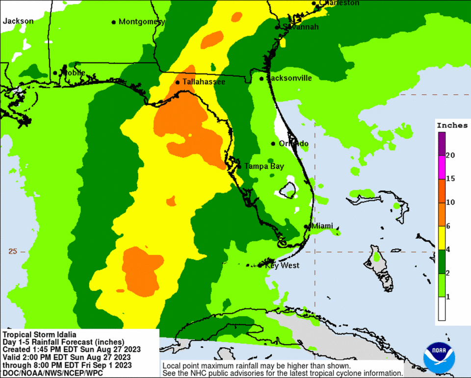
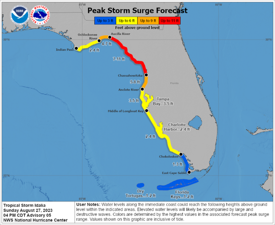
Storm surge is likely to be the biggest threat for this storm. The hurricane center’s latest prediction called for up to 11 feet of surge near the Aucilla River, up to five feet for Tampa Bay and two feet for the Florida Keys.
Rhome, on the morning video update, also cautioned that even a weaker storm could bring dangerous storm surge to Florida’s west coast, which is especially vulnerable to that particular threat.
“It will not take a strong system or a direct hit to produce significant storm surge,” he said.
Rhome warned Floridians inside the watch areas that it was time for action. Storm preparations should be completed by Monday evening for most spots, he said.
“If you’re within the watch areas, it is imperative you move beyond just watching this event and start taking action to protect yourself from potential impacts,” he said.
Evacuation orders, if needed, may begin as soon as Monday in some parts of the state. In the afternoon press conference, DeSantis emphasized that people should look to their local officials for evacuation orders and other messaging.
READ MORE: Did you miss the last Florida hurricane tax holiday? Here’s how to save on supplies
He warned that Floridians around the path of the storm should anticipate losing power. Energy-dependent people, like the elderly or people with medical needs, should seek out a shelter in preparation of losing power, DeSantis said.
When asked by a Tampa Bay Times reporter about how involved the state would be in evacuation orders, DeSantis stressed that it would be a local matter, because he said local leaders are the ones who have the ability to enforce the orders.
DeSantis has previously defended the evacuation calls for Hurricane Ian, saying that with the storm’s uncertain path, local leaders had few options.
Hurricane Franklin and more
Elsewhere in the Atlantic basin, the hurricane center is watching Hurricane Franklin, the second of the season, and a disturbance. As of Sunday afternoon, Franklin was a Category 2 hurricane with 100 mph maximum sustained winds and on track to become a Category 4 over the next few days.
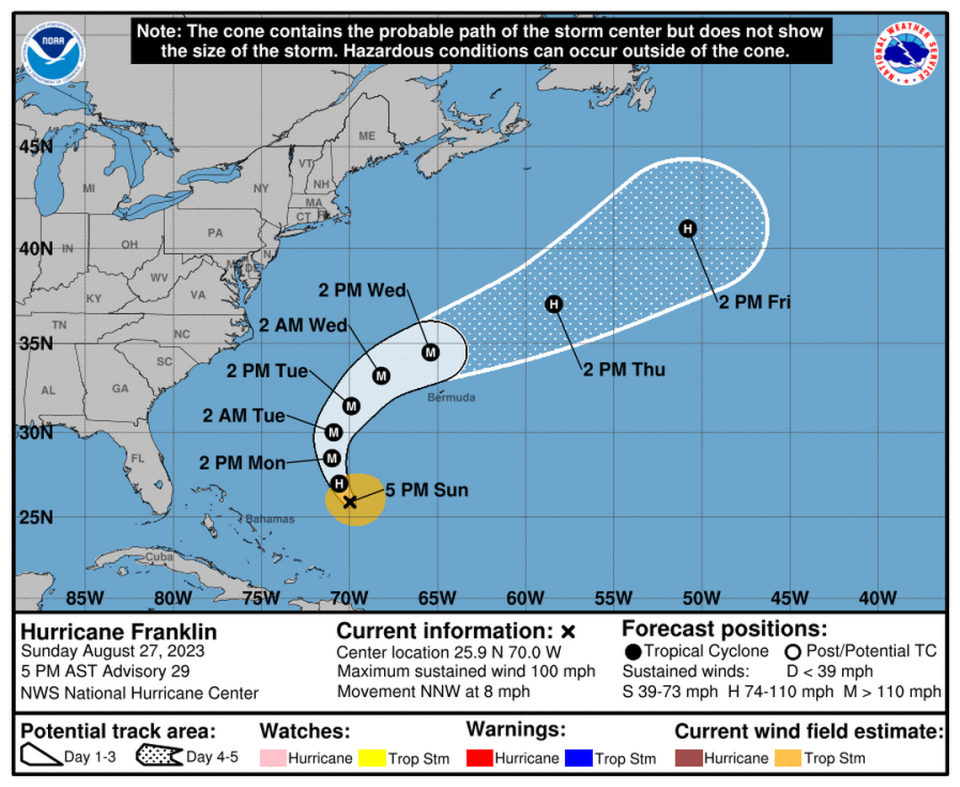
The powerful storm’s projected path over the week keeps it mostly far from land, deep in the Atlantic. But on Wednesday, Franklin could skirt the coast of Bermuda, potentially bringing damaging winds and heavy rain.
Sunday morning, the hurricane center also began tracking a tropical wave due to roll off Africa’s west coast in a few days. They gave it a near-zero chance of developing in the next two days and 20% shot over the next seven days.
Tampa Bay Times Staff Writer Romy Ellenbogen and Miami Herald staff writer Omar Rodríguez Ortiz contributed to this article.

