Florida Peninsula to remain hotbed for stormy weather through Sunday


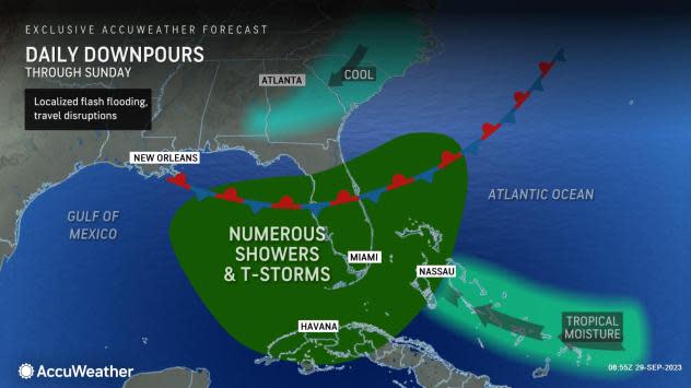
The Sunshine State has struggled to live up to its reputation over the past week as a slow-moving tropical disturbance has brought days of rain which has pushed monthly precipitation totals above the historical averages for several locations. AccuWeather meteorologists say a welcome reprieve from the daily deluge is on the way.
Dry air has pushed southward enough to end the risk of torrential downpours over the Florida Panhandle and the northern part of the peninsula. That protection should last through Sunday. This dry air will eventually press farther south but not before more soggy weather ruins outdoor plans and disrupts travel through the rest of the weekend.
Since Sept. 24, West Palm Beach, Florida, has picked up 8.02 inches of rain, with more on the way. In Miami, a whopping 12.76 inches of rain fell in the month of September, compared to the historical average precipitation for the month of 10.22 inches. The city has not recorded a completely rain-free day since Sept. 12. Orlando has also recorded more precipitation than is typical for the month.
Numerous showers and thunderstorms are expected to persist through Sunday across central and southern portions of the peninsula.
 |
"Some areas will get hit by downpours multiple times a day and/or for several days in a row, while other places may have only a single shower or thunderstorm the entire time through Sunday," AccuWeather Chief On-Air Meteorologist Bernie Rayno said.
Because of the repeating and slow-moving nature of the storms, in addition to the rain falling over already saturated ground, there will be the risk of flash and urban flooding, and water may tend to collect in low-lying areas following persistent torrential downpours.
Not only can the downpours hinder outdoor work and recreational activities, such as those spending time at central Florida theme parks, but sudden lightning strikes can be dangerous to golfers and those trying to squeeze in a few hours at the beach or fishing excursions.
The persistent nature of thunderstorms in the waters surrounding the Florida Peninsula will create rough surf and locally strong rip currents. Along the northeastern coast of Florida, a stiff breeze from the northeast will bring above-average tides, coastal flooding and rough surf conditions.
AccuWeather meteorologists say the risk of tropical development in these waters has diminished over the coming days, due to strong winds and intrusions of dry air.
Many of the thunderstorms may tend to congregate along the Florida Gulf Coast and Keys during the late-night and early-morning hours before wandering inland and toward the Atlantic coast later in the day and during the evening. However, there will be some exceptions.
AccuWeather forecasters urge motorists to be prepared for blocked roads due to high water and avoid driving along flooded roads. High water could damage vehicles, and rising water could cause vehicles to become submerged and put drivers and passengers at risk. Roads can also be compromised underneath floodwaters.
 |
The downpours are not expected to expand to the Mississippi Valley, where water levels are near low levels from a year ago.
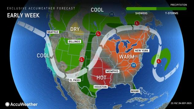
Through the first week of October, AccuWeather meteorologists say drier air will have an easier time of making it southward across the Florida Peninsula, resulting in more sunshine and showers and thunderstorms that are fewer and farther between.
Want next-level safety, ad-free? Unlock advanced, hyperlocal severe weather alerts when you subscribe to Premium+ on the AccuWeather app. AccuWeather Alerts™ are prompted by our expert meteorologists who monitor and analyze dangerous weather risks 24/7 to keep you and your family safer.
