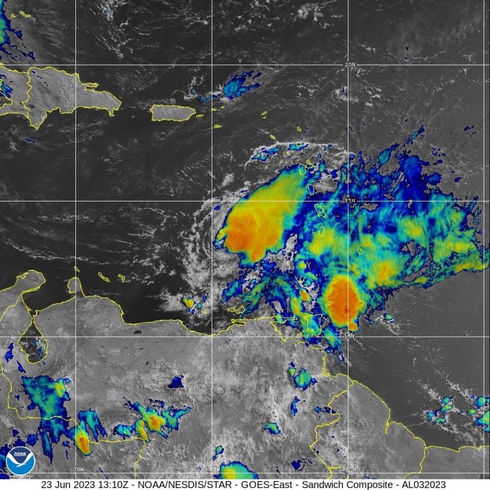
Center of Tropical Storm Bret over southeastern Caribbean. See latest spaghetti models
Tropical Storm Bret is moving west after passing over the Lesser Antilles overnight as a strong tropical storm.
The center of the storm is located over the southeastern Caribbean Sea, according to the latest advisory from the National Hurricane Center.
Bret was joined overnight by a new storm: Tropical Storm Cindy
Bret is expected to weaken in the Caribbean and dissipate by Saturday night or Sunday.
However, parts of Hispaniola and Jamaica could see tropical downpours associated with the storm over the weekend, according to AccuWeather.
'Unprecedented' hurricane season: Tropical Storm Bret and (possible) Cindy may mean active hurricane season ahead
Tropical Storm Bret: See spaghetti models, projected path and storm activity for Florida
Spaghetti models, forecast path for Tropical Storm Bret
Can't see the spaghetti models?
Tropical Storm Bret: What you need to know

Location: 235 miles west of St. Vincent; 1,358 miles southeast of West Palm Beach
Maximum sustained winds: 60 mph
Movement: west at 21 mph
Pressure: 1002 mb
More on Tropical Storm Cindy: Tropical Storm Cindy forms in Atlantic. Get latest spaghetti models, expected impacts
What's happening in the tropics? NHC now tracking Tropical Storms Cindy and Bret. See spaghetti models, expected impacts
How strong is Tropical Storm Bret and where is it going?
At 11 a.m., the center of Tropical Storm Bret was located 235 miles west of St. Vincent. Exact location: near latitude 13.3 North, longitude 64.7 West.
Bret is moving toward the west near 21 mph, and this general motion is expected to continue through the weekend. On the forecast track, the center of Bret will continue moving westward away from the Windward Islands and across the eastern and central Caribbean Sea during the next couple of days.
Maximum sustained winds remain near 60 mph, with higher gusts. Tropical-storm-force winds extend outward up to 125 miles from the center.
Weakening is forecast during the next couple of days, and Bret is expected to dissipate over the central Caribbean Sea by Sunday.
The estimated minimum central pressure based on data from the Air Force Hurricane Hunters is 1002 mb.
Rare June hurricanes: Is a rare June hurricane possible? Forecasters are keeping their eyes on latest storm
Key messages from the Hurricane Center: What you need to know about Tropical Storm Bret
Bret is moving westward over the southeastern Caribbean Sea, but trailing rainbands with embedded gusty winds continue to affect portions of the Windward Islands. These conditions should gradually subside through the day.
NOAA hurricane season forecast: NOAA predicts 'near normal' hurricane season with 12-17 named storms and 5-9 hurricanes
Looking ahead: Positions and maximum winds forecast for Tropical Storm Bret
12 hours: 50 mph
24 hours: 45 mph
36 hours: 40 mph
48 hours: 35 mph
60 hours: dissipated
Watches and warnings in effect for Tropical Storm Bret
All tropical storm watches and warnings have been discontinued.
What impact could Tropical Storm Bret have and what areas could be affected?
Trailing rainbands with embedded gusty winds continue to affect portions of the Windward Islands. These conditions should gradually subside through the day.
Wind: Gusty winds should continue to subside across the Windward Islands over the next few hours.
Rainfall: Rainfall associated with Bret is expected to diminish across the Lesser Antilles later today as the storm continues to move westward across the Caribbean. Additional rainfall amounts of 1 to 2 inches are possible across portions of the Lesser Antilles from Guadeloupe south through St Vincent and the Grenadines, including Barbados. The heavy rainfall could lead to flash flooding, especially across areas of higher terrain. Urban flooding is also possible.
Surf: Swells generated by Bret are expected to gradually subside along the Lesser Antilles through the day. Swells are likely to increase in areas adjacent to the central Caribbean Sea later today and on Saturday. These swells are likely to cause life-threatening surf and rip current conditions.
Click on map to see watches, warnings in effect in your area
What do watches and warnings from NHC mean?
What is storm surge? Graphics explain the deadly weather event
Hurricane warning: A hurricane warning means that hurricane conditions are expected somewhere within the warning area. A warning is typically issued 36 hours before the anticipated first occurrence of tropical-storm-force winds, conditions that make outside preparations difficult or dangerous. Preparations to protect life and property should be rushed to completion.
Hurricane watch: A hurricane watch means that hurricane conditions are possible within the watch area. A watch is typically issued 48 hours before the anticipated first occurrence of tropical-storm-force winds, conditions that make outside preparations difficult or dangerous.
Tropical storm warning: A tropical storm warning means that tropical storm conditions are expected somewhere within the warning area within 36 hours.
Tropical storm watch: An announcement that sustained winds of 39 to 73 mph are possible within the specified area within 48 hours in association with a tropical, subtropical, or post-tropical cyclone.
Storm surge warning: A storm surge warning means there is a danger of life-threatening inundation, from rising water moving inland from the coastline, in the indicated locations. This is a life-threatening situation. Persons located within these areas should take all necessary actions to protect life and property from rising water and the potential for other dangerous conditions. Follow evacuation and other instructions from local officials.
Storm surge watch: A storm surge watch means there is a possibility of life-threatening inundation, from rising water moving inland from the coastline, in the indicated locations during the next 48 hours.
This article originally appeared on Palm Beach Post: NHC tracking Tropical Storm Bret. Spaghetti models, expected impact

