Tropical Storm Cristobal heads toward Gulf Coast. Some areas could see a foot of rain
Rain bands from Tropical Storm Cristobal reached the northern Gulf Coast on Saturday morning as the storm moves north through the Gulf of Mexico.
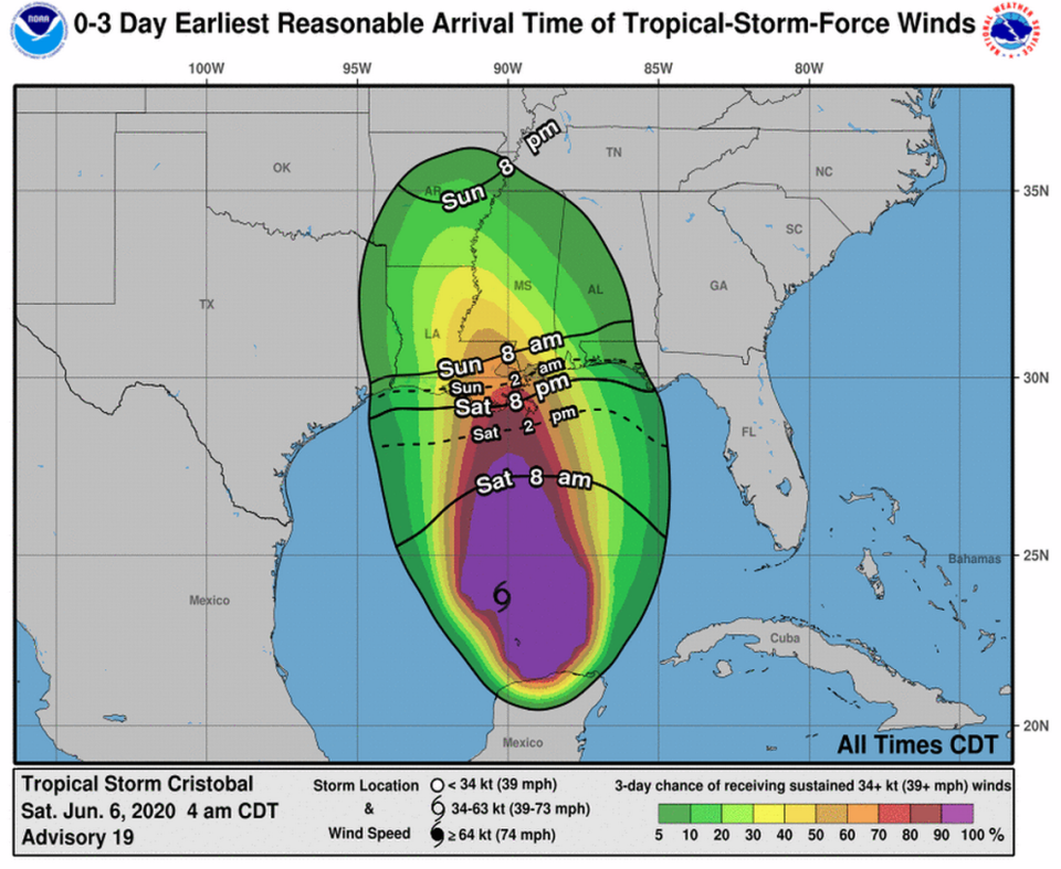
A tropical storm warning is in effect for southeastern Louisiana, Mississippi, Alabama and the western Florida Panhandle. Tropical storm-force winds could arrive as early as Saturday night.
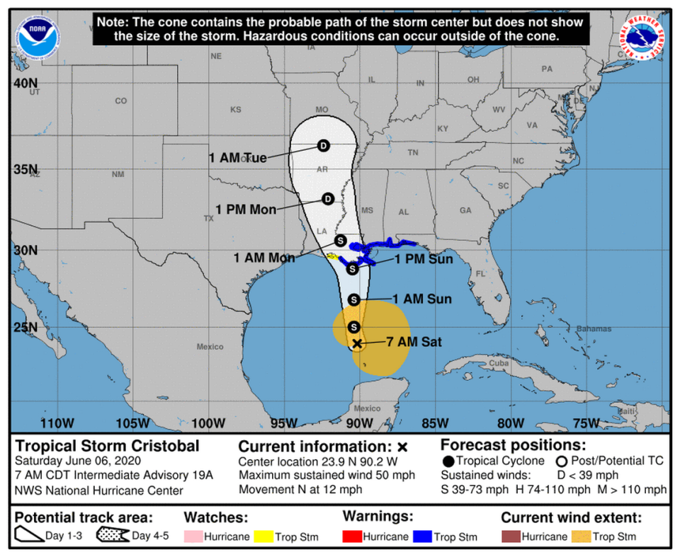
As of Saturday morning, Cristobal was moving north at 12 mph with maximum sustained winds of 50 mph, according to the National Hurricane Center. Forecasters say tropical storm-force winds extend 240 miles from the center of the storm.
Forecasters say the storm could strengthen slowly before it makes landfall Sunday.
The center of the storm is forecast to continue moving north over the Gulf of Mexico on Saturday, approaching the coast by Sunday morning. “Cristobal’s center is then forecast to move inland across Louisiana late Sunday through Monday morning, and northward across Arkansas and Missouri Monday afternoon into Tuesday,“ according to the National Hurricane Center.
“Heavy rainfall will continue across west and north Florida today, spreading from east to west across the eastern and central Gulf Coast from the Florida Panhandle into Louisiana today into Sunday,” the National Hurricane Center said Saturday.
“This heavy rain will move into the Lower Mississippi Valley on Monday. Significant flooding will be possible on smaller streams, especially where heavier rainfall occurs over portions of the Gulf Coast and Lower Mississippi Valley,” the Hurricane Center said.
Residents from southeast Louisiana to the Florida Big Bend should brace for deadly storm surge and flooding this weekend as the slow moving-storm is sure to bring heavy rains and high winds to the region, according to the National Weather Service. The advisory impacts “immediate coastal areas” stretching from the Mississippi River to Ocean Springs.
Forecasters also issued a storm surge warning for portions of coastal Mississippi including Biloxi, Gulfport and Pass Christian. The southeast Louisiana coastline could also see minor to moderate flooding, forecasters say.
“Heavy rainfall will spread onto portions of the Gulf Coast, from East Texas to Florida, this weekend into early next week, with areas of flash flooding and rapid rises on smaller streams and rivers possible,” according to the weather service.
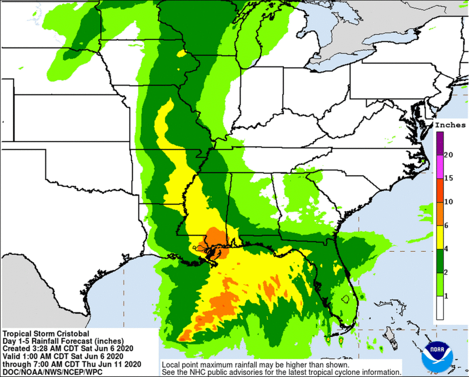
Forecasters say the potential for storm surge flooding could reach more than 3 feet above ground with some areas expecting “total rainfall in excess of 10 inches” this weekend. Local areas could see up to 12 inches before the storm moves out of the area early next week.
Further inland, forecasters say 2 to 4 inches of rain could cause flash flooding and flooding of streams in the lower- to mid-Mississippi Valley.
The advisory also includes Intracoastal City, Louisiana, the metro-New Orleans area and the Florida Panhandle.
Strong winds are expected to arrive “well in advance of and extend well east of Cristobal’s center,” the National Hurricane Center said. The Gulf Coast could see gusts as soon as 8 p.m. Saturday with the storm’s center not expected to make landfall in Louisiana until around 1 a.m. Monday, McClatchy News reported, citing forecasts.
Forecasters warn the storm could produce tornadoes Sunday in southern Louisiana, Mississippi, Alabama and the western Florida Panhandle.
Even without tornadoes, the high winds and rain could cause damage. Potential impacts include damage to porches, sheds and unanchored mobile homes with the risk of fences and road signs being blown over. Additionally, storm debris from downed trees and branches could make some roads impassable, according to forecasts.
In a Friday news conference, New Orleans Mayor LaToya Cantrell urged residents to stay weather aware and make the necessary preparations as the storm moves in.
“We hope it moves fast,” she told reporters, according to local station WWL-TV. “We do not want it to rest over the city of New Orleans for hours and hours.”
The storm has spent the last several days dumping torrential rains over southern Mexico and portions of Central America.
The storm was previously downgraded to a depression but has since strengthened back to a tropical storm.
A flood watch remains in effect for much of the Gulf Coast through 7 a.m. June 9, according to the National Weather Service.

