Tropical Storm Don holds steady as hurricane center watches wave. Check out the forecast
Tropical Storm Don held its 50 mph winds and a disturbance in the eastern Tropical Atlantic could strengthen as it moves over warmer waters this weekend.
Here’s the National Hurricane Center’s 5 p.m. Thursday advisory on Don and 2 p.m. advisory on the disturbance.
Where is Tropical Storm Don?
Tropical Storm Don was about 955 miles west of the Azores, the Portuguese islands in the middle of the north Atlantic Ocean Thursday morning.
Where is Don going?
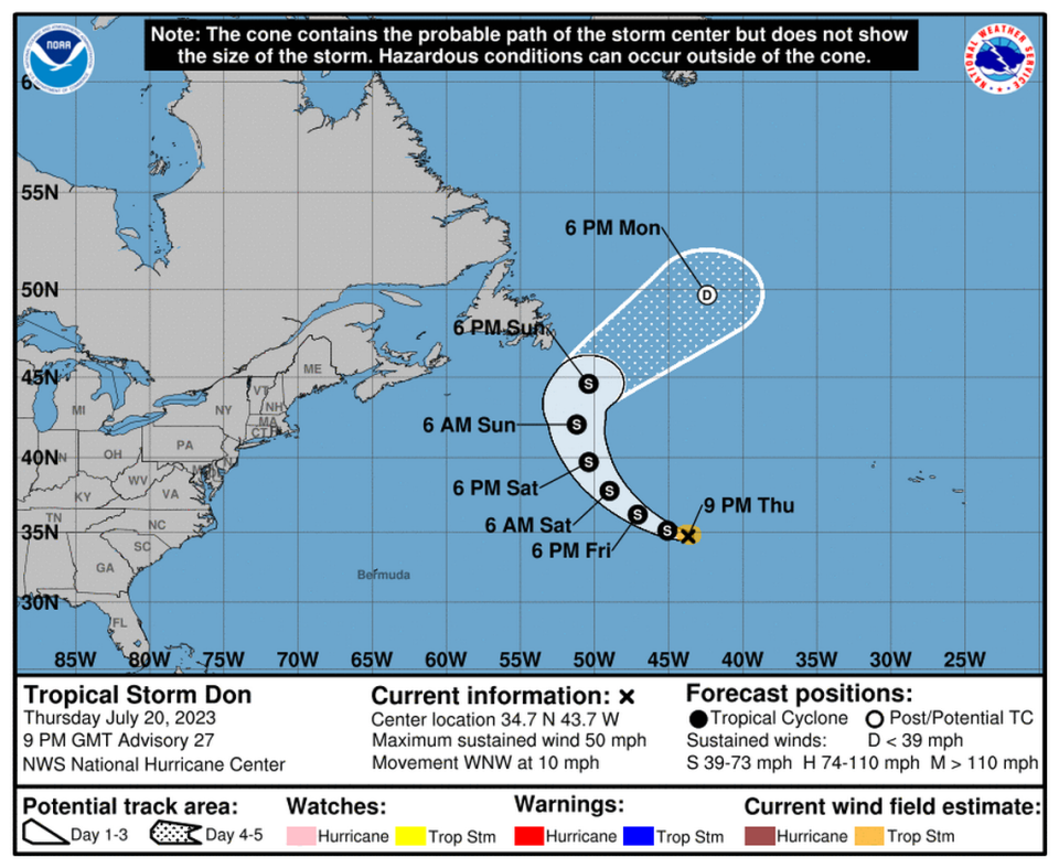
Don was moving west-northwest at 10 mph.
Don’s projected path: The storm should continue in this general motion and pick up speed over the next couple days. The center forecasts a turn to the northwest by Friday night, followed by a turn north over the weekend.
Will Don get stronger?
Don maintained near 50 mph sustained winds with higher gusts Thursday afternoon. “Little change in strength is forecast during the next couple of days. Weakening is forecast to begin later this weekend,” hurricane specialist Daniel Brown wrote in the advisory. By Monday afternoon Don should be reduced to a depression heading further out to sea.
Tropical storm-force winds extend outward up to 60 miles from the center.
The North Atlantic average sea surface temperature is back to +4 standard deviations above the 1991-2020 mean (and still climbing). Relative to that baseline, the latest anomaly is +1.3°C and has 1-in-26,300 odds of happening. Yet here we are. pic.twitter.com/Ocxr7dykSo
— Brian McNoldy (@BMcNoldy) July 20, 2023
Will it affect Florida, North Carolina or anywhere in the United States?
On the forecast track, Don should remain over the open waters of the central Atlantic and is not expected to impact land.
What watches or warnings are in effect?
There are no watches or warnings.
Where is the disturbance?
The National Hurricane Center is tagging the wave off Africa for possible development by later this weekend into early next week. Some obstacles ahead, including dry air and a quick pace, so low developments odds for now. Something to watch for the eastern Caribbean islands. pic.twitter.com/9rtpo6U3Pt
— Michael Lowry (@MichaelRLowry) July 19, 2023
The tropical wave was a few hundred miles southwest of the Cabo Verde Islands and interacting with the Intertropical Convergence Zone, a region near the equator where the trade winds of the Northern and Southern Hemispheres come together, according to NASA. The intense sun and warm water of the equator heats the air in this zone, raises its humidity and casts the air aloft, where it expands and cools and leads to an almost perpetual series of thunderstorms, NASA explains.
That’s what’s happening to this wave, the hurricane center’s Daniel Brown said in his 2 p.m. Thursday advisory. “The combination of these features is producing an elongated area of showers and thunderstorms over the eastern and central tropical Atlantic.”
The wave’s direction?
Dry air to the north may prevent significant organization during the next couple of days, but environmental conditions could become more conducive for some development this weekend as the system moves west across the central tropical Atlantic, Blake said.
If the disturbance manages to gain traction, “We’ll want to keep an eye to the disturbance into next week, mainly for any potential impacts to the eastern Caribbean islands as early as next Monday,” said WPLG hurricane specialist Michael Lowry on his Eye on the Tropics blog.
▪ Formation chance through 48 hours is at 0%.
▪ Formation chance through seven days is at 20%.
When will we know more?
The next update will be at 11 p.m. Thursday.
Tropical Storm #Don Advisory 27: on Continues West-Northwestward. https://t.co/tW4KeGe9uJ
— National Hurricane Center (@NHC_Atlantic) July 20, 2023
Daily storms and heat. When is Saharan dust coming to change Florida’s weather a bit?
It can be hard to understand exactly how much hotter this summer is than previous ones, but this chart from @BMcNoldy makes the most sense to me.
https://t.co/lwmfuZyZku pic.twitter.com/PvHKUSnToS— Alex Harris (@harrisalexc) July 19, 2023
Ocean and pool in Florida in ‘bathtub conditions.’ Is it safe to swim? What experts say

