Hurricane Dorian Expected to Hit Florida as a Category 4. Here’s the Latest Track and Forecast
Hurricane Dorian is predicted to make landfall on Florida’s Atlantic coast or possibly in Georgia as a powerful Category 4 storm late Sunday or early Monday, according to the latest forecast from the National Hurricane Center.
It’s unclear exactly where Hurricane Dorian will make landfall, but Dan Kottlowski, a meteorologist with AccuWeather, says the storm is likely to impact “almost the entire state” of Florida at the least.
Kottlowski predicts the storm will hit somewhere between Melbourne, Fla. and Miami.
Florida Governor Ron DeSantis declared a state of emergency on Wednesday afternoon.
As Hurricane #Dorian approaches, I’ve declared a state of emergency to ensure local governments and emergency management agencies have ample time, resources and flexibility to get prepared. Please continue to follow local reports and @FLSERT for updates. https://t.co/FyQM6wd8er
— Ron DeSantis (@GovRonDeSantis) August 28, 2019
“It’s important for Floridians on the East Coast to monitor this storm closely,” DeSantis said in a statement. “Every Florida resident should have seven days of supplies, including food, water and medicine, and should have a plan in case of disaster.”
The National Hurricane Center predicts wind speeds could hit 130 mph by Sunday morning, with gusts of 160 mph, making it a Category 4 hurricane.
Category 4 hurricanes typically cause “catastrophic” damage, power outages for weeks or months and involve a high risk of injury or death to people, livestock and pets from flying and falling debris.
By Thursday morning, the storm had moved past Puerto Rico and the Virgin Islands, having done minimal damage. It was in open water, about 220 miles north, northwest of Puerto Rico and some 370 miles from the southeastern Bahamas, according to the National Hurricane Center.
Forecasters say Hurricane Dorian should move over the central Bahamas on Thursday and Friday before approaching the northwestern Bahamas on Saturday.
Maximum sustained winds are near 85 mph, but the storm is expected to strengthen into a major hurricane on Friday and “remain an extremely dangerous hurricane through the weekend,” according to the National Hurricane Center.
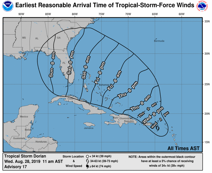
Heavy rains are expected over parts of Florida, the Bahamas and elsewhere in the southeastern United States this weekend and into the middle of next week, according to forecasts. The Hurricane Center advises that residents in these areas should “monitor the progress of Dorian and ensure that they have their hurricane plan in place.”
Tropical-storm-force winds from #Dorian could begin in parts of Florida *as early as* Saturday or Saturday night. Now is the time to begin thinking about what kinds of preparations you might need to make over the next couple of days. https://t.co/f5cqCroirU pic.twitter.com/mIGTVR6SUG
— National Hurricane Center (@NHC_Atlantic) August 28, 2019
What is Hurricane Dorian’s projected path?
On Thursday morning, Hurricane Dorian was in open water headed for the Bahamas. It is expected to gather strength in the Atlantic before turning towards the Southeastern U.S. coastline, potentially making landfall in Florida early Monday.
“All indications are that by this Labor Day weekend, a powerful hurricane will be near the Florida or southeastern coast of the United States,” reads the NHC’s forward-looking forecast discussion. However, forecasters warn that it’s difficult to predict Dorian’s exact path that far in advance: “The average 5-day track error is around 200 miles.”
“We’re in wait-and-see mode on Florida,” says Lance Wood, a meteorologist with the National Weather Service. “Obviously there’s a threat but it’s really too early to hone in on any specific impacts on any area.” Florida and coastal Georgia could face the most significant threats, according to Wood.
There are no coastal watches or warnings in effect at this time, but forecasters say residents in the northwestern and central Bahamas should monitor the hurricane’s progress. Hurricane watches could be issued in the northwestern Bahamas Thursday night or Friday.
On Monday, Tropical Depression Erin formed in the Atlantic Ocean between Bermuda and the United States, but it is not expected to threaten the U.S. East Coast.
How strong could Hurricane Dorian become?
Hurricane Dorian was passing over the U.S. and British Virgin Islands and Puerto Rico on Wednesday afternoon as a Category 1 hurricane. The hurricane is projected to strengthen later in the week as it passes Turks and Caicos and the Bahamas.
It is expected to produce anywhere from four to eight inches of rain in parts of the Bahamas and the Southeast United States, with 12 inches in some isolated areas.
The National Hurricane Center notes that rainfall “may cause life-threatening flash floods.”
Swells around Puerto Rico and the U.S. and British Virgin Islands “should gradually diminish” on Thursday but they are “likely to begin affecting the east-facing shores of the Bahamas and the southeastern United States coast during the next few days.” These swells are likely to cause life-threatening surf and rip current conditions.
Dorian caused power cuts overnight in Barbados earlier in the week, where crews began clearing downed trees and repairing the electrical grid early Tuesday. Government officials said that by Tuesday morning, public transportation would resume and businesses would reopen, according to the AP.
How the Bahamas are preparing for Hurricane Dorian
Dorian is expected to produce four to eight inches of rain in the northwestern Bahamas.
Lindsay Thompson, spokesperson for the National Emergency Management Agency in the Bahamas tells TIME that the nation is no stranger to hurricanes after three consecutive years of storms.
The agency has issued alerts for the northwest islands, including New Providence, Eleuthera, the Abaco Islands, Grand Bahama, North Handros, Bimini and the Berry Islands.
Thompson says officials are expecting downed power lines, major roof and structural damage to homes. Authorities have alerted businesses to properly secure their properties to minimize damage. The emergency management agency has also posted a shelter list for residents who feel the need to evacuate their homes.
Thompson says preparation is key and disaster committees across the island nation have prepared for this scenario since the start of hurricane season.
“In essence, Bahamians have prepared,” she says. “We take this seriously because we’ve been impacted past three years, there was Hurricane Joaquin, Matthew and Irma so now we’re leaving nothing to chance. Our message to residents is to just prepare, not to take anything lightly.”
How hard was Puerto Rico hit?
Hurricane Dorian caused limited damage in the northern Carribean as it left the region Wednesday night, the Associated Press reported.
Some reports of power outages and flooding were reported across the Puerto Rican islands of Vieques and Culebra and the U.S. and British Virgin Islands.
But the effects were largely limited—a relief to residents, especially those in Puerto Rico, where just two years ago Hurricane Maria led to the deaths of some 3,000 people.
President Donald Trump had declared a state of emergency in Puerto Rico on Tuesday, one day before the hurricane’s arrival.
On Thursday, he tweeted, “Puerto Rico is in great shape with Hurricane Dorian taking a largely different route than anticipated. Thank you to FEMA, first responders, and all, for working so hard & being so well prepared. A great result! The bad news, Florida get ready! Storm is building and will be BIG!”
Puerto Rico is in great shape with Hurricane Dorian taking a largely different route than anticipated. Thank you to FEMA, first responders, and all, for working so hard & being so well prepared. A great result! The bad news, Florida get ready! Storm is building and will be BIG!
— Donald J. Trump (@realDonaldTrump) August 29, 2019
Puerto Rico seemed to be spared any heavy wind and rain. Ángel Figueroa, president of a union that represents power workers told the Associated Press that several hundred customers were without power across Puerto Rico by Wednesday evening.
Culebra also appeared to face minimal, if any, effects from the hurricane.
“We’re happy because there are no damages to report,” Culebra Mayor William Solís told The Associated Press, noting that only one community lost power.

