Tropical Storm Elsa, 5th named storm of season, forms. Will track bring it to Florida?
Tropical Storm Elsa, a record-breaking fifth named storm of the season, formed early Thursday in the Atlantic — with South Florida in its cone of uncertainty for early next week.
However, the National Weather Service in South Florida cautions that forecasters are still “very uncertain” about the later projections for Elsa’s track.
“Interests in Florida should monitor updates to the forecast for this system, but it is too soon to determine what if any impacts could occur there next week given the uncertainty in the long-range forecast,” the National Hurricane Center wrote in its 5 a.m. Thursday advisory.
Elsa is the earliest-known fifth named storm recorded for the Atlantic basin in the “satellite” era, which began in 1966, according to the National Hurricane Center. The previous record was formerly held by Edouard on July 6, 2020.
July 1st - Tropical Storm Elsa continues to move westwards across the Central Atlantic this morning. It’s still way too early to determine what impacts, if any, are expected for South Florida. Continue to monitor further updates on TS Elsa through the holiday weekend. #flwx pic.twitter.com/IkSaaNqgJM
— NWS Miami (@NWSMiami) July 1, 2021
A tropical storm warning is in effect for Barbados, Martinique, St. Lucia, St. Vincent and the Grenadines. A tropical storm watch is in place for Grenada and its dependencies as well as the southern and western coasts of Haiti from the southern border of the Dominican Republic to Le Mole le St. Nicholas.
As of the 8 p.m. update, watches have also been issued for the southern coast of the Dominican Republic from the Haiti/Dominican Republic border eastward to Punta Palenque as well as Jamaica.
Forecasters expect additional watches and warnings will be issued later Thursday and say that tropical storm conditions will likely begin in the warning and watch areas on Friday.
The state says it has created a “contingency” storm plan in case Elsa comes to South Florida when crews are still working at the partially collapsed building in Surfside, near Miami Beach, where more than 140 people are still missing.
Where is Elsa now and where is it going?
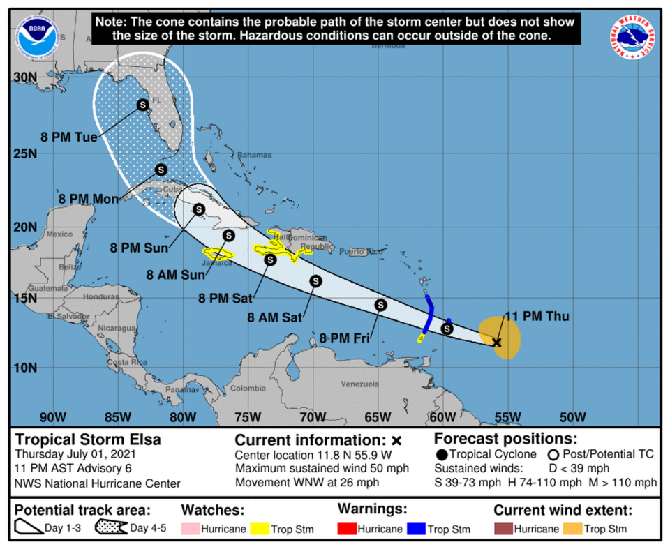
Elsa was about 260 miles east-southeast of Barbados, as of the hurricane center’s 11 p.m. Thursday advisory, which shifted the projected track slightly east from the 8 p.m. advisory.
The storm was speeding west at 26 mph with maximum sustained winds at 50 mph with higher gusts and is expected to pick up its pace in the next day or so as it moves west-northwest. Tropical-storm-force winds extend up to 140 miles from the center, mainly to the north.
Over the next day or so Elsa is expected to strengthen as it travels over a patch of warm water, high humidity and low wind shear. But forecasters said Elsa’s rapid pace could split the storm’s top and bottom half up, which could halt strengthening.
“A fast-moving storm in this part of the Atlantic normally has a hard time staying organized and staying un-sheared,” said Levi Cowan, a meteorologist who runs Tropical Tidbits, in a video analysis of the storm posted Thursday afternoon.
Cowan said if the storm remains stacked after it passes through the Windward Islands it has the potential to strengthen further, a projection reflected in the hurricane center’s forecast, which calls for Elsa’s winds to reach 60 mph in a few days.
The current projected path also takes Elsa over some mountainous islands, another potential weakening factor.
The system is forecast to pass near or over portions of the Windward Islands or the southern Leeward Islands on Friday before moving into the eastern Caribbean Sea late Friday. It is then expected to move near the southern coast of Hispaniola on Saturday.
Why is there so much uncertainty early next week with Tropical Storm #Elsa? Because the two most reliable models (Euro and GFS) and their ensembles differ drastically. Two different solutions with the placement of the Bermuda High, land interaction, upper level environment, etc. pic.twitter.com/jLnK8XfnbY
— Sammy Hadi (@SammyHadiWx) July 1, 2021
The hurricane center says there’s still a lot of uncertainty in Elsa’s track after Day 3, partially because the storm doesn’t have a defined center, which makes it harder for models to track. Some models have it turning northward after interacting with Hispaniola. Other models take Elsa across western Cuba and into the southeastern Gulf of Mexico.
Accuweather, a for-profit forecasting firm, predicted Thursday at 3 p.m. that Elsa will briefly strengthen into the first hurricane of the season right before it crosses Hispaniola and then weakens back to a tropical storm.
In the 5 p.m. discussion, the hurricane center explained that the UKMET model shows Elsa weakening to a trough near western Cuba while another model, the GFS, shows it strengthening into a hurricane. In light of that uncertainty, the hurricane center’s latest track showed Elsa remaining a tropical storm through Tuesday.
Elsa is expected to produce three to six inches of rain on Friday across the Windward and the southern Leeward Islands, including Barbados, with isolated areas possibly seeing up to eight inches of rain. This rain may lead to isolated flash flooding and mudslides.
The hurricane center said there is a “risk of wind and rainfall impacts” for portions of the Virgin Islands, Puerto Rico, Hispaniola, Cuba, the Turks and Caicos, and the southeastern Bahamas through early next week.
11pm Thu NHC wind speed probabilities for Elsa show a small South Florida increase over as the track has nudged slightly east. This far out from the storm, these minor track adjustments will cause the probabilities to go up/down at times. We will watch out for steady increases. pic.twitter.com/QZ1LxJkqJU
— Craig Setzer (@CraigSetzer) July 2, 2021
Elsa is already a record-breaking storm in more ways than just timing.
According to NOAA data, the fifth storm of the season usually forms on August 31. It also formed from the far east, which is unusual this early in the season when storms usually form closer to the Caribbean.
The fact that Elsa formed east of 50°W is “more alarming” than its timing, Brian McNoldy, a research professor at the University of Miami, wrote in a blog post.
“A tropical storm has only formed so early in the year and so far east once before, in 1933. If you’re not aware, 1933 was among the most active seasons on record, so hopefully Elsa is not a harbinger,” he wrote.

