Tropical Storm Elsa is forecast to hit the Midlands. Here’s what to expect.
For the second time in as many weeks, the Midlands is preparing to be affected by a tropical storm.
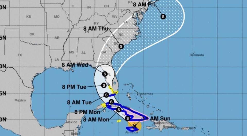
At the end of June, Tropical Storm Danny rumbled through South Carolina, and now Tropical Storm Elsa, previously classified as a hurricane, is forecast to move up the Southeast and into the Palmetto State.
Like Danny, the current forecast predicts Elsa will not unleash a torrent a severe weather on the Columbia area.
As of Sunday, no warnings or watches have been issued for the Midlands, where the effects of the tropical storm are not expected to be as severe as they might be in the Lowcountry and along the South Carolina coast, National Weather Service forecaster Hunter Coleman told The State.
“There’s a lot of uncertainty with how this storm looks,” Coleman said. “It has to go through Cuba where it could weaken. We’re uncertain what will happen until it goes through Cuba.”
As of Sunday afternoon, the tropical storm had maximum sustained winds of 60 mph, with higher gusts recorded, according to the National Hurricane Center. It was about 40 miles southeast of Cuba, but was moving northwest at about a 14 mph clip. Tropical-storm-force winds extend outward up to 115 miles from the center, the National Hurricane Center said.
Regardless of strength, Elsa is expected to pass through South Carolina on Wednesday, Coleman said. Effects of the storm could be felt on Tuesday, but Elsa is not expected to arrive in the Palmetto State until Wednesday night, according to the National Weather Service.
Heavy rain and breezy conditions are predicted to be the greatest impacts on the Columbia area, Coleman said.
Wind of 20-25 mph are possible in the Midlands, according to the National Weather Service. Because of that, Coleman recommended securing any loose objects outside of homes.
Powerful winds could cause considerable damage to trees and branches, which creates the possibility of downed power lines and outages.
Between 1-1.5 inches of rain could fall in Columbia, as there is a 50% chance of precipitation on Wednesday, according to the forecast. Higher amounts of rainfall are possible in certain areas affected by storms.
“We will see an increase in tropical moisture and rainfall,” Coleman said. “There will be nice days on Sunday and Monday, but conditions will start to get unsettled Tuesday.”
There is currently a 20% chance Elsa will be a tropical storm when it reaches the Midlands, according to Coleman.
Over the past day, Elsa has tracked further to the east, according to Coleman. A continued shift toward the east, and out to the Atlantic Ocean, would minimize any severe weather effects caused by the storm in the Midlands, the National Weather Service said.
But if Elsa moves on a western track, it could increase the heavy rainfall and wind threat, as well as introduce the chance of a potential tornado, according to the National Weather Service.
“The trend is gradually shifting right toward the coast, but we’re still days away from” the forecast being more certain,” Coleman said. “Our impact is likely minimal, with lots of rain and stronger wind than normal. We’re not expecting a massive storm.”
By Thursday, Elsa is forecast to have moved quickly out of the Columbia area, Coleman said.
But as Elsa approaches on Tuesday, temperatures are expected to approach a high of 94 degrees before dropping to the low 70s overnight, according to the forecast. Temperatures are forecast to be in the 80s and 90s through the rest of the week, and more rain and thunderstorms are possible in the Columbia area.
But this is subject to change, for better or worse.
“Stay tuned to the forecast,” Coleman said.

