Tropical Storm Elsa is moving along Florida coast. When and where will it make landfall?
Hurricane Elsa weakened into a tropical storm overnight and is forecast to make landfall in Florida Wednesday.
The storm, which was moving north almost parallel with Florida’s west coast, is now approaching the northern Florida Gulf Coast, spreading heavy rains and gusty winds inland across the state, according to the National Hurricane Center’s 8 a.m. advisory.
Here’s what to know:
Where is Elsa?
Elsa was about 35 miles west of Cedar Key and about 115 miles northwest of Tampa, as of the 8 a.m. advisory.
The storm was moving north near 14 mph with maximum sustained winds near 65 mph with higher gusts. Its tropical-storm-force winds extend outward up to 90 miles from the center.
Where is Elsa going? How strong will it be?
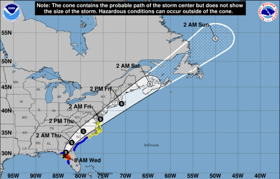
While Elsa is forecast to see little change in strength before landfall, there is still a chance that the storm might see a short-lived re-intensification, the hurricane center said. Because of this, a hurricane warning remains in effect for portions of Florida’s west coast.
On the forecast track, Tropical Storm Elsa is expected to move near or over portions of Florida’s west coast before making landfall Wednesday, late morning or sometime in the afternoon, somewhere in the northern Florida Gulf Coast. The storm should then see some weakening as it moves inland, the hurricane center said.
The storm is forecast to then move across the southeast and Mid-Atlantic states through Thursday. The system is expected to become extratropical by the time it reaches the Canadian Maritimes in 72 hours.
Besides tropical-storm force winds, forecasters expect western and northern portions of Florida to see between three to six inches of rain with isolated areas possibly seeing up to nine inches of rain Wednesday. This could cause flash and urban flooding and minor to isolated moderate river flooding.
Tornadoes are also possible across west-central to north Florida into Wednesday afternoon. There is also a risk of life-threatening surf and rip current conditions across portions of the Keys and Florida’s west coast. There is also a risk of storm surge. A storm surge warning is in effect for Florida’s west coast from Bonita Beach to the Aucilla River, including Tampa Bay, with 3 to 5 feet of water possible, according to the hurricane center.
Elsa Watches/Warnings
▪ Hurricane warning in effect for the west coast of Florida from Chassahowitzka to the Steinhatchee River
▪ Tropical storm warning is in effect for Florida’s west coast from south of Chassahowitzka to the middle of Longboat Key. Warnings are also in effect north of the Steinhatchee River to Ochlockonee River and for the Mouth of St. Marys River, Georgia to Little River Inlet, South Carolina.
▪ Tropical storm watch in effect north of Little River Inlet, South Carolina to Chincoteague, Virginia. Watches also in effect for Pamlico and Albemarle Sounds.
▪ Storm surge warning in effect for the west coast of Florida from the middle of Longboat Key to the Aucilla River, including Tampa Bay.
▪ Storm surge watch in effect west of the Aucilla River to the Ochlockonee River.
This article will be updated.

