Tropical Storm Elsa drenches Cuba. Track nudges west, likely easing impact on Florida Keys
South Florida got its first taste of Tropical Storm Elsa Monday afternoon as the outermost bands began to lash the region with brief, intense bouts of rain likely to last through Tuesday.
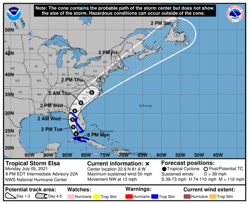
The storm’s projected track jogged a bit west early Monday — easing the threat for South Florida, including most of the Lower Florida Keys, which now appear likely to see a windy, wet sideswipe rather than a direct hit from a small system that’s expected to strengthen after crossing Cuba.
Elsa’s path took it over most of central Cuba on Monday — where nearly 200,000 people have been evacuated and heavy rains were sweeping the island — before it’s expected to re-emerge in the Florida Straits early Tuesday morning. On Monday, storm surge and tropical storm warnings were extended north up the state and west to the Big Bend area. The easternmost part of the Panhandle was under a tropical storm watch.
Its potential Florida landfall site also shifted farther north overnight.
As of the 11 p.m. advisory from the National Hurricane Center, Elsa appeared on track to make landfall in Florida in Horseshoe Beach, north of the Suwannee River, Wednesday morning. It was about 20 miles north, northeast of Havana and 80 miles south, southwest of Key West.
The storm weakened as it made landfall in Cuba to 50 mph maximum sustained winds, but by the 11 p.m. advisory the storm strengthened to 60 mph maximum sustained winds. Tropical storm force winds extended only 70 miles from the center. Its pace dipped slightly to 12 mph. Elsa’s wind field also shrunk, with the strongest winds mostly within 60 miles of its center.
Tropical Storm Elsa makes landfall in Cuba; heavy rainfall blankets central provinces
Cuba evacuated hundreds of thousands of people from the southern provinces in advance of the storm, which drenched the area in flooding rains on Sunday and Monday. Power and phone service were reported down in parts of the country but it was too early to get damage assessments.
In Havana — which may experience some of Elsa’s strongest winds — hundreds of people were evacuated from buildings that are considered unsafe, especially in older areas of the city, the Civil Defense office said. They fear gusty winds could topple some structures that have fallen into disrepair. The storm already has been blamed for two deaths in the Dominican Republic and one in St. Lucia, and crushed crops in Haiti.
Forecasters said they’ll have a better idea of exactly how Elsa will affect Florida after it finishes crossing Cuba. The latest prediction calls for Elsa’s maximum sustained winds to climb back to 65 mph before it makes landfall.
“Some restrengthening of the cyclone is likely after it moves into the Gulf of Mexico, but vertical shear associated with a broad upper-level trough over the Gulf is likely to limit intensification,” forecasters wrote in the 5 p.m. advisory.

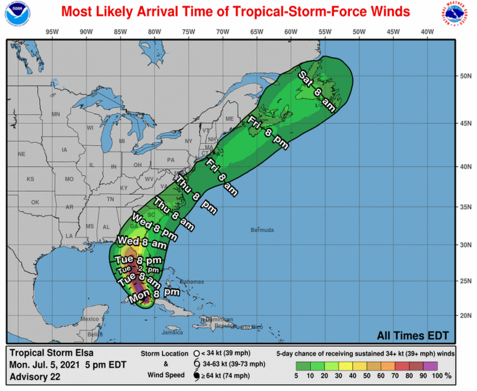
South Florida was firmly out of the cone of uncertainty, but forecasters said gusty winds and heavy rain were still possible through Wednesday as the storm grinds up the west coast. The northernmost fringe bands swept across Southeast Florida later in the afternoon — nothing major, but Florida Power & Light was already reporting just over 150 power outages Monday evening in Broward County. Miami will experience its gustiest winds (around 25 mph) midmorning Tuesday, according to the National Weather Service.
The Lower Keys could start to feel Elsa’s winds as early as Monday night, but more likely early Tuesday morning. The National Weather Service showed Key West could see maximum sustained winds in the low 40s with gusts as high as 55 mph around 4 a.m. Tuesday.
The Lower and Middle Keys on Monday remained under a tropical storm warning.
“This is mostly going to be squalls,” said meteorologist Jon Rizzo, of the National Weather Service in Key West, during Monday’s 9:30 a.m. countywide conference call of Keys leaders.
“You’re not going to have hours and hours of sustained winds,” he said.
5am Mon advisory timing for tropical storm conditions through the Keys & up west coast of Florida where Tropical Storm watches/warnings are in effect. A Storm Surge watch (water 2-4 feet above ground) is also in effect for the west coast. Gusty downpours in Miami-Dade & Broward pic.twitter.com/f3eODAmwwz
— Craig Setzer (@CraigSetzer) July 5, 2021
Tropical storm-force winds are likely to arrive in Key West in the form of frequent, fast-moving squalls between 10 p.m. to midnight and continue through about 12 p.m. Tuesday.
Monroe County officials recommended that those in RVs, mobile homes, travel trailers and boats either leave the Keys by sunset Monday or find safer housing throughout the duration of the storm.
Residents should “have homes, boats and yards secure and be ready to shelter in place by sunset,” said Shannon Weiner, director of the emergency management office on Monday morning.

The Tampa Bay and Bradenton area could see six inches of rain this week as the storm nears, while the Keys are more likely to see two to four and Miami could see one or two.
Florida could also see one to two feet of storm surge from the Keys north to Indian Pass, with Tampa Bay and the Cedar Key area expecting the most at three to five feet.
Winds are likely to pick up in Bradenton starting Tuesday morning with a peak of 30 mph sustained winds and gusts of up to 39 mph that evening, according to the weather service.
Listen to today's top stories from the Miami Herald:
Subscribe: Apple Podcasts | Spotify | Amazon Alexa | Google Assistant | More options
Warnings and watches
▪ A tropical storm warning is in effect for the Cuban provinces of Matanzas, Mayabeque, Havana and Artemisa; the Florida Keys from Craig Key westward to the Dry Tortugas, and the west coast of Florida from Flamingo to the Ochlockonee River. At 11 p.m. the warning for Cienfuegos and Villa Clara was canceled.
▪ A storm surge watch is in effect for the west coast of Florida from west of the Aucilla River to Ochlockonee River.
▪ A tropical storm watch is in effect from west of the Ochlockonee River to Indian Pass, Florida.

