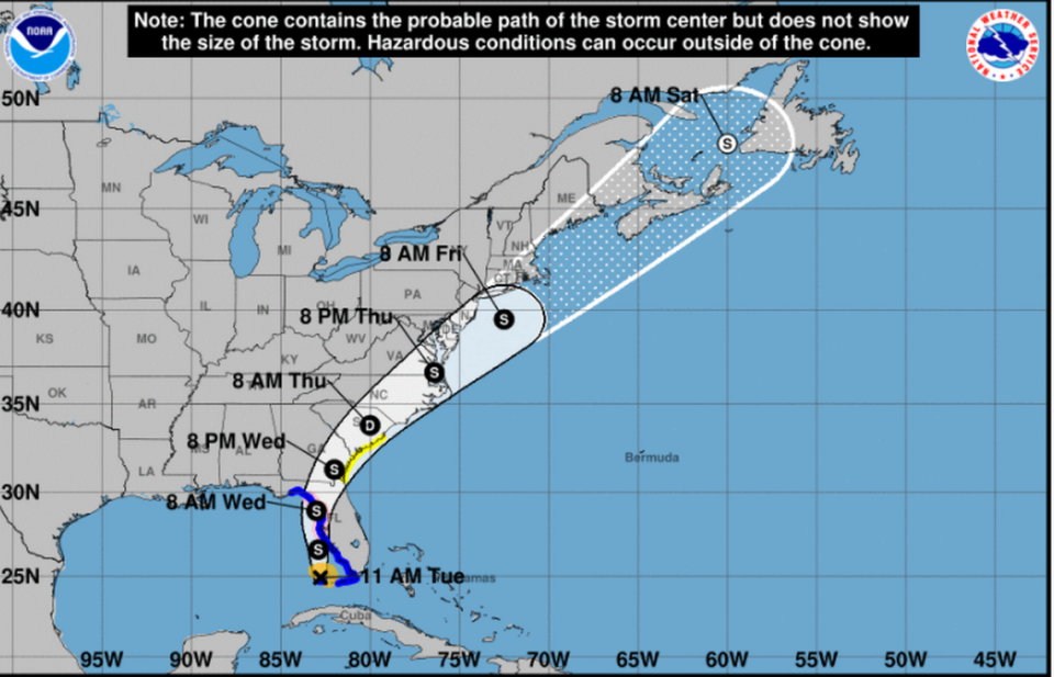
Tropical Storm Elsa nears the Keys — where is it going next? Here’s what the track shows
Tropical Storm Elsa doused the Florida Keys with rain and gusty winds Tuesday.
The rest of South Florida will also get some rough weather, with the potential for tornadoes. Forecasters predict an 80% chance of rain and thunderstorms in Miami-Dade and a 70% chance in Broward County, according to the National Weather Service.
The storm is expected to slowly strengthen as it creeps along Florida’s west coast, and could be near hurricane strength before making landfall south of Cedar Key in the Waccasassa River on Wednesday morning.
A hurricane warning was issued Tuesday for the west-central and Big Bend coast of Florida, from Egmont Key to the Steinhatchee River. A hurricane watch is also in effect for the area.
Here’s what to know about Elsa’s track:
Where is Elsa now?
Elsa was about 65 miles west-northwest of Key West with maximum sustained winds at 60 mph with higher gusts, as of the National Hurricane Center’s 11 a.m. Tuesday advisory. It was about 215 miles south of Tampa.
Tropical-storm-force winds extend outward up to 70 miles from the center. Forecasters measured a peak 1-minute sustained wind of 56 mph gusting to 64 mph in Sand Key. Key West International Airport also recently measured a peak sustained wind of 43 mph gusting to 59 mph.
When will South Florida see the worst of Tropical Storm Elsa’s rain and wind?
Where is Elsa going and how strong will it be?

Elsa was moving toward the north-northwest at a slightly slower 10 mph pace and is expected to make a turn toward the north-northeast Wednesday.
On the forecast track, Elsa is expected to pass near the Florida Keys Tuesday, and will then move near or over portions of the state’s west coast Tuesday into Wednesday.
While it could near hurricane-level strength before making landfall along the north Florida Gulf coast, the hurricane center expects it will weaken once it moves inland.
From there, the storm’s projected path takes it toward the Ocala National Forest, through Georgia and the Carolinas (where it’s expected to weaken to a depression) before emerging in the Atlantic near Virginia Beach late Thursday night.
What should South Florida and the rest of the state expect?
Tropical storm conditions will continue Tuesday in the Florida Keys from Craig Key west to the Dry Tortugas, which are under a tropical storm warning.
Tropical-storm-force winds and heavy rain are expected to spread north, especially toward the Lower Keys with three to five inches of rain likely, with some isolated areas possibly seeing up to eight inches of rain through Wednesday, according to the National Weather Service in Key West. This may result in considerable flash and urban flooding, along with minor to isolated moderate river flooding.
Impacts from TS #Elsa are currently being felt in the Lower & Middle Keys. TS force wind gusts & heavy rainfall are accompanying squalls pivoting through the Lower Keys at this time. These conditions will continue through the morning. #KeyWest #flwx #FLKeys pic.twitter.com/Xvv4Mx1dH9
— NWS Key West (@NWSKeyWest) July 6, 2021
Tropical storm conditions should be felt in west-central Florida and the Big Bend region Tuesday night and early Wednesday, when hurricane conditions could be possible. Tropical storm conditions could also be possible late Tuesday west of the Ochlockonee River to Indian Pass.
Forecasters say most of Florida should expect between two to four inches of rain, with isolated areas possibly seeing up to six inches of rain through Wednesday night. This could result in isolated flash, urban and minor river flooding.
Swells are also forecast to cause life-threatening surf and rip current conditions across portions of the Florida Keys and the state’s west coast through Wednesday. As for tornadoes, there’s a possible risk across the state through Tuesday night. North Florida could also see some tornadoes Wednesday.
The combination of a storm surge and the tide will also cause normally dry areas near Florida’s coast to be flooded by rising waters moving inland from the shoreline, according to the hurricane center. The Florida Keys from Craig Key to Dry Tortugas and from Ochlockonee River to Indian Pass are forecast to see one to two feet of storm surge. Flamingo to Bonita Beach is forecast to see one to three feet. The Aucilla River to Ochockonee River and from Bonita Beach to Englewood, including Charlotte Harbor, are forecast to see between two to four feet. From Englewood to Aucilla River, including Tampa Bay, expect three to five feet of storm surge.
Elsa watches/warnings in Florida
▪ The west-central and Big Bend coast of Florida from Egmont Key to the Steinhatchee River are under a hurricane watch.
▪ A storm surge warning is in effect for the west coast of Florida from Bonita Beach to the Aucilla River, including Tampa Bay. A storm surge watch is in effect west of the Aucilla River to the Ochlockonee River.
▪ A tropical storm warning remains in effect for the Florida Keys from Craig Key westward to the Dry Tortugas and the west coast of Florida from Flamingo northward to Ochlockonee River.
▪ A tropical storm watch is in effect west of the Ochlockonee River to Indian Pass, FL and from the Mouth of St. Marys River to South Santee River, SC.
