Tropical storm warning, storm surge watch issued for Florida’s west coast as Eta nears
Tropical Storm Eta has grown a little stronger as it moved north-northeast Tuesday night posing a risk of flooding over South Florida and an eventual landfall in the Florida Panhandle, forecasters say.
As of 10 p.m., the National Hurricane Center issued a tropical storm warning for the Florida west coast from Bonita Beach to the Suwannee River, along with a storm surge watch from Bonita Beach to the Steinhatchee River, including Tampa Bay and Charlotte Harbor. The Dry Tortugas are also under a tropical storm warning.
The Florida Gulf Coast is now under a tropical storm watch from north of the Suwannee River to the Aucilla River.
Earlier in the day, the NHC swung the projected path 150 miles east, which would send Eta grinding up Florida’s west coast as a tropical storm all week before making landfall in the Panhandle on Sunday.
The storm could drench an already waterlogged South Florida through Wednesday, but forecasters don’t expect Eta’s winds to reach the southeast coast.
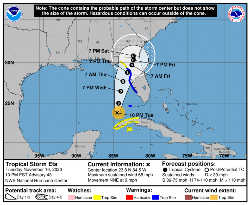
As of the 10 p.m. advisory, Eta was about 120 miles west-northwest of the Dry Tortugas and about 315 miles south-southwest of Tampa with maximum sustained winds near 65 mph with higher gusts, according to the National Hurricane Center. It was moving north-northeast at about 9 mph and its tropical-storm-force winds extended 70 miles from the center.
While some additional strengthening is possible in the next day or so, including a chance that Eta could become a hurricane, the storm should start to see some weakening Wednesday night or early Thursday, according to the hurricane center.
Tropical Storm Eta left parts of South Florida flooded. When will the water recede?
What type of weather is Eta causing?
Swells generated by Eta are expected to affect the northern coast of Cuba, southern and western Florida, and the Florida Keys during the next day or so and will likely cause life-threatening surf and rip current conditions, according to the hurricane center.
In terms of rainfall, western Cuba should expect to see an additional 1 to 3 inches of new rain. South Florida should expect to see an additional 1 to 2 inches of new rain, forecasters said.
The hurricane center estimates that isolated areas in Cuba will have seen about 25 inches of rain associated with Eta the past few days. In South Florida, isolated areas will have seen 15 to 20 inches of rain.
“Flash and river flooding will be possible in western Cuba through tonight, along with landslides in areas of higher terrain. Additional flash and urban flooding will be possible in South Florida tonight, especially across previously inundated areas, and eventually across portions of west Florida, the eastern Florida Panhandle, and north Florida Wednesday through Friday,” forecasters wrote Tuesday.
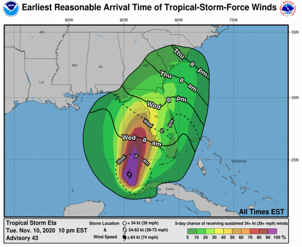
Tropical-storm-force winds will also be possible overnight in the Dry Tortugas and along Florida’s west coast in areas under a tropical storm warning through late Wednesday. Tropical storm conditions are also possible in the watch area along the Florida Big Bend by Thursday.
Elsewhere in the Atlantic basin
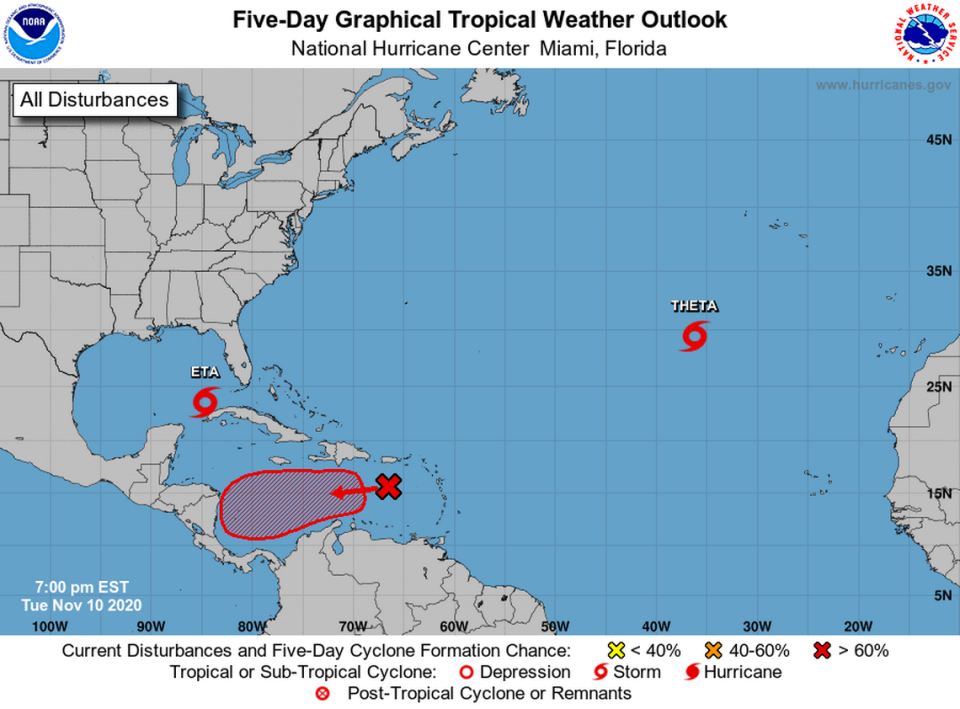
The hurricane center is also tracking Subtropical Storm Theta, the record-breaking 29th named storm of the 2020 season, and a tropical wave in the Caribbean.
Forecasters gave the wave an 80% chance of strengthening to a tropical depression in the next five days and a 20% chance of strengthening by Thursday. If it strengthens further into a tropical storm, it would be named Iota.

