Tropical storm expected to hit Texas coast Tuesday
Tropical Storm Warnings are in effect Monday and Tuesday along the middle Texas coast.
The National Weather Service is monitoring a tropical disturbance moving across the Gulf of Mexico. The storm is expected to strengthen to a tropical storm before moving inland Tuesday morning, according to a NWS Corpus Christi tweet.
At 1 p.m. Monday, the storm was moving at a speed of 16 miles per hour, located about 423 miles west of Port Aransas. By 4 p.m. the center of Tropical Depression Nine was “moving toward the west near 18 mph. A fast motion to the west is expected to continue, and the system is forecast to move inland over south Texas by midday Tuesday,” the weather service said in a release Monday afternoon.
Winds of 40 miles per hour or higher are expected, as well as flooding and a high risk of rip currents for the islands from Baffin Bay to Port O'Connor. Lesser impacts are expected in Nueces, Copano and San Antonio Bays.
High winds could damage porches, awnings, carports, sheds and unanchored mobile homes. Large tree limbs might also be broken and some trees might snap or be uprooted.
Local governments on alert
The City of Corpus Christi Emergency Operations Center is also monitoring the storm. The city issued its own advisory Monday covering potential local storm impacts.
"City departments have been ready to respond if necessary," the city's news release stated.
The city also stated the city's airport expects no flight delays due to the storm but passengers should download their airline's app to monitor flight schedules.
"Residents are asked not to tamper with City manhole covers and should not remove covers to sewer sanitary clean-outs on their property as this could lead to storm water entering the sewer system," the news release noted.
The City of Portland also issued an update and preparedness tips to residents Monday via its News Flashes email alert system. Residents can sign up for notifications at the www.portlandtx.com website.
Storm impacts expected across the region
South Texas residents should be prepared for potential scattered power and communication outages.
A storm surge of one to three feet of beach inundation and moderate beach erosion is expected Tuesday.
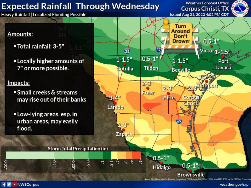
Three to five inches of rain are expected and isolated amounts of up to seven inches are possible.
Due to dry soil conditions, only isolated flash flooding is expected, primarily in urban areas or typical low spots.
Rain bands with tropical storm force wind gusts are expected to reach coastal waters this evening and spread across the region tonight.
Isolated tornadoes could occur early Tuesday morning and into the afternoon hours. Any isolated tornados will likely move quickly westward around the northern outskirts of the storm.
Plans announced by public schools, colleges
Corpus Christi ISD announced late Monday that all schools will have a two-hour delay Tuesday. Elementary schools will begin at 9:50 a.m. Middle and high schools will begin at 10:50 a.m. Bus schedules will also run on a two-hour delay. Unless otherwise notified by a supervisor, employees should report to work on Tuesday two hours later than their usual start time.
"We are closely monitoring the weather, and will keep families and employees informed of any additional changes," the announcement stated. "Thank you, and stay safe!"
All Flour Bluff ISD schools will have a two-hour delay due to the weather.
"Unless otherwise notified by their supervisor, FBISD employees are expected to report to work on Tuesday, August 22nd two hours later than their usual start time," the Flour Bluff ISD's Executive Director of Communications Kristen Bily stated via email Monday night.
Bus schedules will also run on a two-hour delay, and the district noted in its email that that due to the weather conditions, buses serving "Primary and Elementary will drop off students directly at the front of the campuses. Due to the weather delay, there will be flexibility with tardies for tomorrow."
The two-hour start times reported by the district are:
ECC: 9:30
Primary: 9:35
Elementary: 9:35
Intermediate: 10:05
Junior High: 10:15
High School: 10:30
Hornet Learning Academy: 10
"We are closely monitoring the weather and the direction of the storm, and we will keep families and employees informed of any additional changes," Bily said in the email.
The storm will also impact operations at Del Mar College, which will pause campus operations until noon Tuesday at all DMC campuses and centers.
"Employees should work remotely until noon on Tuesday, then resume their normal schedules on campus in the afternoon," a release from the College Relations Office stated Monday night. "Employees unable to work remotely should contact their supervisors for further instructions. Those deemed as essential personnel will be contacted by their direct supervisor if required to report to work."
Texas A&M University-Corpus Christi "will shift to remote work operations due to anticipated inclement weather conditions," the university announced Monday via email. "The university anticipates shifting back to in-person work at 1 p.m. on Tuesday, Aug. 22, and normal operations are expected to return on Wednesday, Aug. 23, across all university offices and services."
The notice also said the Texas A&M University-Corpus Christi student tuition deadline for fall 2023 was extended to Wednesday, Aug. 23.
The university recommended those not signed up for the university's "Code Blue" system sign up to receive alerts and updates via codeblue.tamucc.edu to confirm mobile phone numbers.
Operations are suspended between 8 a.m. and 5 p.m. at all Texas A&M University-Kingsville locations, including the Citrus Center in Weslaco, the university announced Monday evening.
"Critical and emergency operations, including Residence Life, University Police Department, Food Services, and Facilities Services, will remain operational," the university's Assistant Director of Communications Sarah Tuley said via email. "All classes will continue remotely into the evening. University officials will assess the status of on-campus evening activities by 1 p.m. (Tuesday)."
Alerts are available
The National Weather Service Forecast Office Corpus Christi shares storm updates and tips on social media.
The City of Corpus Christi and Nueces County provide emergency alerts through voice or text message. To sign up, text BeReadyCCNC to 888777 to receive alerts. Corpus Christi residents can also sign up online at www.cctexas.com/alertsignup.
Gulf of Mexico holds possible disturbance, National Hurricane Center reports
More: Hurricane season 2023: Here's everything to prepare you in South Texas
This article originally appeared on Corpus Christi Caller Times: Tropical storm expected to hit Texas coast Tuesday

