Puerto Rico bracing for 'catastrophic flooding' as Hurricane Fiona bears down on island
Fiona became the third hurricane of the 2022 Atlantic season Sunday morning, as residents of Puerto Rico and the Dominican Republic brace for the storm's impact there.
Hurricane warnings are in effect for Puerto Rico and portions of the Dominican Republic. Hurricane conditions are expected on Puerto Rico Sunday, and in parts of the eastern Dominican Republic Sunday night and Monday. Torrential rain and life-threatening mudslides are possible. Fiona's maximum sustained winds have increased to 85 mph.
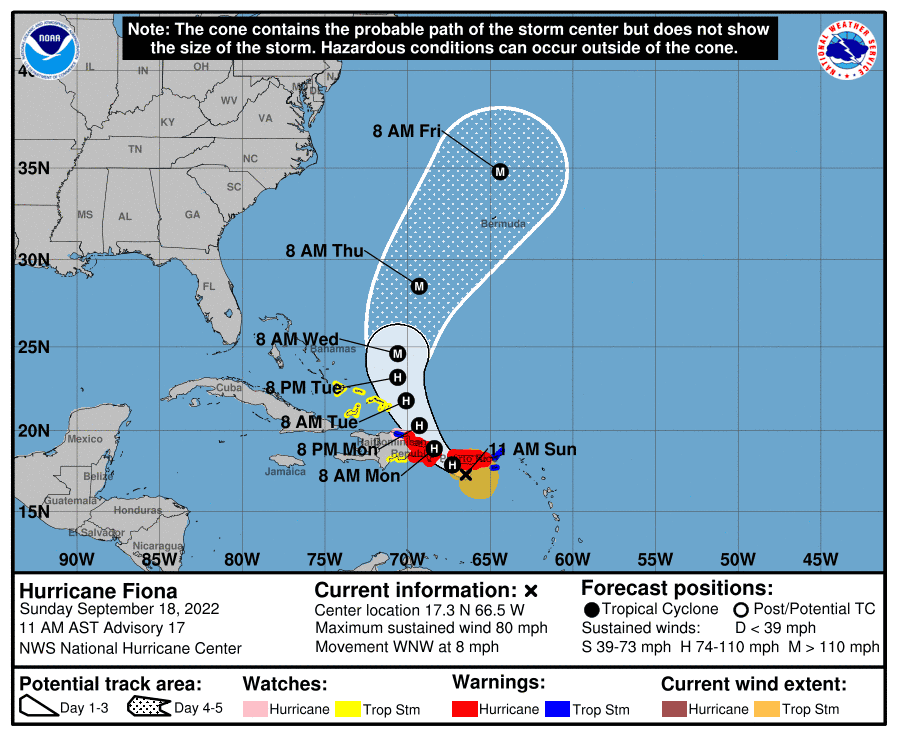
Sunday afternoon, the National Hurricane Center warned of "catastrophic flooding" on Puerto Rico as the storm nears the island. The forecast calls for 12 to 16 inches of rain, with up to 25 inches in isolated areas. Storm surge of up to 3 feet is also possible along the southern coast of Puerto Rico.
The U.S. and British Virgin Islands were experiencing tropical storm conditions early Sunday, and conditions continue to deteriorate on Puerto Rico as Fiona continues on a west-northwestward track, with the center about 25 miles southwest of Ponce. The storm's center is expected to move near or over Puerto Rico Sunday afternoon or evening.
Fiona will then move near the northern coast of the Dominican Republic Sunday night and Monday, and near or to the east of the Turks and Caicos Islands on Tuesday.
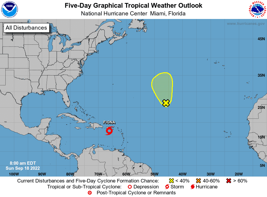
The National Hurricane Center is also watching a tropical wave over the central Atlantic that has a 20% chance of becoming a tropical depression over the next 5 days.
► Your guide to preparing for the 2022 hurricane season in Florida
Revised seasonal forecast: Atlantic hurricane season off to slow start. But top forecasters still expect above-normal activity
WeatherTiger: Tropical Storm Fiona is born — could it threaten Florida?
Here's the latest update from the NHC as of 2 p.m. Sept. 18:
Tropical Storm Fiona
Location: 25 miles southwest of Ponce, Puerto Rico
Maximum wind speed: 85 mph
Direction: West-northwest at 8 mph
Next advisory: 5 p.m. ET
At 200 PM AST (1800 UTC), the center of Hurricane Fiona was located near latitude 17.8 North, longitude 66.9 West. Fiona is moving toward the west-northwest near 8 mph (13 km/h). A northwestward motion is expected to begin later today and continue through Monday, followed by a turn toward the north-northwest on Tuesday.
On the forecast track, the center of Fiona will continue to pass near or over southwestern and western Puerto Rico this afternoon and evening. Fiona will then move near the northern coast of the Dominican Republic tonight and Monday, and near or to the east of the Turks and Caicos Islands on Tuesday.
Maximum sustained winds have increased to near 85 mph (140 km/h) with higher gusts. Additional strengthening is forecast during the next 48 hours while Fiona moves near Puerto Rico, the Dominican Republic and over the southwestern Atlantic.
Tropical-storm-force winds extend outward up to 140 miles (220 km) and hurricane-force winds extend outward up to 30 miles (45 km) from the center. A weather station at Ponce-Isla de Gata Puerto Rico recently reported a sustained wind of 69 mph (111 km/h) and a gust to 103 mph (166 km/h). The minimum central pressure estimated from Hurricane Hunter aircraft and NOAA Saildrone observations is 986 mb (29.12 inches).
Hurricane #Fiona Advisory 17: Fiona Becomes a Hurricane. Torrential Rains and Mudslides Expected Across Puerto Rico And The Dominican Republic. https://t.co/tW4KeGe9uJ
— National Hurricane Center (@NHC_Atlantic) September 18, 2022
A hurricane warning is in effect for:
Puerto Rico, including Vieques and Culebra
The coast of the Dominican Republic from Cabo Caucedo to Cabo Frances Viejo
A hurricane watch is in effect for:
North coast of the Dominican Republic from Cabo Frances Viejo westward to Puerto Plata
A tropical storm warning is in effect for:
U.S. Virgin Islands
British Virgin Islands
North coast of the Dominican Republic from Cabo Frances Viejo westward to Puerto Platas
A tropical storm watch is in effect for:
South coast of the Dominican Republic west of Cabo Caucedo to Barahona
Turks and Caicos Islands
Southeastern Bahamas, including the Acklins, Crooked Island, Long Cay, the Inaguas, Mayaguana, and the Ragged Islands
A Hurricane Warning means that hurricane conditions are expected somewhere within the warning area, in this case within the next 24 hours. Preparations to protect life and property should be rushed to completion.
A Hurricane Watch means that hurricane conditions are possible within the watch area. A watch is typically issued 48 hours before the anticipated first occurrence of tropical-storm-force winds, conditions that make outside preparations difficult or dangerous.
A Tropical Storm Warning means that tropical storm conditions are expected somewhere within the warning area within 36 hours.
A Tropical Storm Watch means that tropical storm conditions are possible within the watch area, generally within 48 hours.
Spaghetti models for Tropical Storm Fiona
See the latest models on where Tropical Storm Fiona could go.
Colorado State University's 2-week forecast for Sept. 15-28
CSU has issued 2-week Atlantic #hurricane forecast (Sep. 15-28) and gives highest odds for above-normal activity (50%) with lower odds for normal (40%) & below-normal (10%). #Fiona should generate enough ACE by itself to approach near-normal level.https://t.co/e18hgwk4Wd pic.twitter.com/47FA7KJN72
— Philip Klotzbach (@philklotzbach) September 15, 2022
Colorado State University's hurricane forecast Sept. 15-28 gives the highest odds for above-normal activity — 50% — with lower odds for normal — 40% — and below-normal — 10%.
When is the Atlantic hurricane season?
The Atlantic hurricane season runs from June 1 through Nov. 30.
When is the peak of hurricane season?

Although the season has gotten off to a quiet start, the peak of the season is Sept. 10, with the most activity happening between mid-August and mid-October, according to the Hurricane Center.
Weather watches and warnings issued for your area
If you can't see any local weather warnings here, you'll need to open this story in a web browser.
Tropical forecast next five days
See the National Hurricane Center's five-day graphical tropical weather outlook below.
Excessive rainfall forecast
What's out there?
Systems currently being monitored by the National Hurricane Center.
What's next?
We will continue to update our tropical weather coverage daily. Download your local site's app to ensure you're always connected to the news. And look at our special subscription offers here.
This article originally appeared on Palm Beach Post: NHC: Hurricane Fiona could bring 'catastrophic flooding' to Puerto Rico

