Tropical Storm Franklin could become strong Category 2 hurricane. See spaghetti models
Tropical Storm Franklin continues to gain strength as it moves over the open waters of the Atlantic, and is expected to become a strong Category 2 hurricane over the weekend, according to the latest advisory from the National Hurricane Center.
Elsewhere in the Atlantic basin, Floridians should keep a close eye on a system moving into the Caribbean Sea from the Pacific. A tropical depression could form as it moves slowly north into the eastern Gulf of Mexico next week.
Invest 92L in the eastern Atlantic could become a tropical depression by the weekend.
The remnants of Tropical Storm Emily, now in the central subtropical Atlantic, are expected to restrengthen into a tropical storm by Friday.
Florida and August hurricanes: As the tropics boil, a cautiously optimistic August hurricane forecast for Florida
Will Florida get a hurricane?
An area of low pressure may develop over the northwest Caribbean Sea by this weekend and move into the eastern Gulf of Mexico early next week, according to the National Weather Service, Melbourne.
While there currently is a moderate chance of tropical cyclone formation through early next week, it's too early to speculate what, if any, impact this system might have on Florida, forecasters said.
All residents should monitor the system closely and be prepared.
Need to restock hurricane supplies? Florida's second tax-free holiday of 2023 is ahead
Tropical Storm Franklin is expected to stay well east of Florida.
"Franklin poses no direct threat to Florida," said the Florida Division of Emergency Management.
While Franklin is expected to become a Category 2 hurricane over the weekend, regardless of how much it intensifies, it will not pose a direct threat to Floridians. However, the storm will cause rough surf and rip currents along Atlantic beaches, said the Florida Public Radio Emergency Network.
How quickly Franklin strengthens will determine its exact path, which remains uncertain since it's poorly organized, according to AccuWeather.
One possibility is that Franklin could turn toward the northwest and wander within a few hundred miles of Bermuda this weekend.
Here's the latest update from the NHC as of 2 p.m.:
Tropical Storm Franklin could become strong Category 2 hurricane

Location: 90 miles east-northeast of Grand Turk Island; 765 miles south-southwest of Bermuda; 710 miles southeast of West Palm Beach
Latitude/longitude: latitude 22.2 North, longitude 69.9 West
Maximum wind speed: 60 mph
Direction: northeast at 7 mph
Tropical Storm Franklin first made landfall about 7:30 a.m. Aug. 23 along the southern coast of the Dominican Republic near Barahona.
Franklin is moving toward the northeast near 7 mph and a northeastward to north-northeastward motion is anticipated over the next day or so, followed by a sharp turn to the north in a couple of days.
Maximum sustained winds have increased to near 60 mph, with higher gusts. Tropical-storm-force winds extend outward up to 115 miles from the center.
Slow strengthening is forecast during the next 48 hours and Franklin could become a hurricane by Saturday.
Current forecasts call for maximum sustained winds to hit 110 mph Sunday, making Franklin a strong Category 2 hurricane. A major hurricanes are Category 3 or higher. A storm becomes a Category 3 storm once winds reach 111 mph.
The latest minimum central pressure is 998 mb.
Spaghetti models for Tropical Storm Franklin
What else is out there and how likely are they to strengthen?

Invest 7: A trough of low pressure located more than 1000 miles east-southeast of Bermuda (the remnants of former Tropical Storm Emily) is producing an elongated area of disorganized showers andthunderstorms.
Recently received satellite wind data suggests that the system has lost organization from yesterday, but a tropical depression or storm could still form as it moves northward over the subtropical central Atlantic. By this weekend, the system is expected to merge with a frontal boundary north of the GulfStream.
Formation chance through 48 hours: medium, 50 percent.
Formation chance through 7 days: medium, 50 percent.

Invest 92L: Disorganized showers and thunderstorms continue in association with an area of low pressure located midway between the Cabo Verde Islands and the northern Lesser Antilles.
While environmental conditions are marginal for additional development, they could become more conducive in a few days.
A tropical depression could form by early next week while the system moves west-northwestward to northwestward into the central subtropical Atlantic.
Formation chance through 48 hours: low, 20 percent.
Formation chance through 7 days: medium, 50 percent.

Disturbance 3: A broad area of low pressure centered over Central America is forecast to move into northwestern Caribbean Sea by this weekend.
Some gradual development of this system is possible thereafter into early next week, and a tropical depression could form while it moves slowly northward, entering the eastern Gulf of Mexico.
Formation chance through 48 hours: low, 10 percent.
Formation chance through 7 days: medium, 60 percent.
Weather watches and warnings issued in Florida
When is the Atlantic hurricane season?
The Atlantic hurricane season runs from June 1 through Nov. 30.
When is the peak of hurricane season?
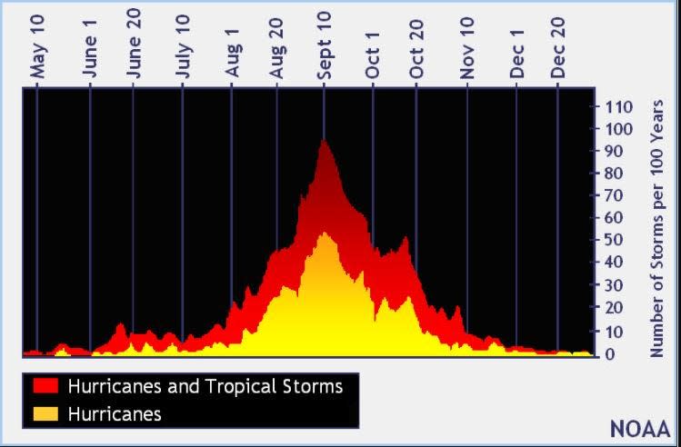
The peak of the season is Sept. 10, with the most activity happening between mid-August and mid-October, according to the Hurricane Center.
Tropical forecast over the next seven days
Excessive rainfall forecast
What's out there?
Systems currently being monitored by the National Hurricane Center.

What's next?
We will continue to update our tropical weather coverage daily. Download your local site's app to ensure you're always connected to the news. And look at our special subscription offers here.
This article originally appeared on Treasure Coast Newspapers: NHC tracking Tropical Storm Franklin, new system approaching Caribbean

