Other storms fade as Tropical Storm Franklin closes in on Haiti, the Dominican Republic
The Atlantic Ocean remained crowded Tuesday, but only two tropical storms posed a threat to land — one of them, Harold, made landfall in Texas and the other, Franklin, was on track toward the island of Hispaniola.
South Florida, for now, remained in the clear. And after a busy start to the week with five tracked systems, by Tuesday two systems had weakened to disturbances and one had dissolved into a remnant low, all far from land.
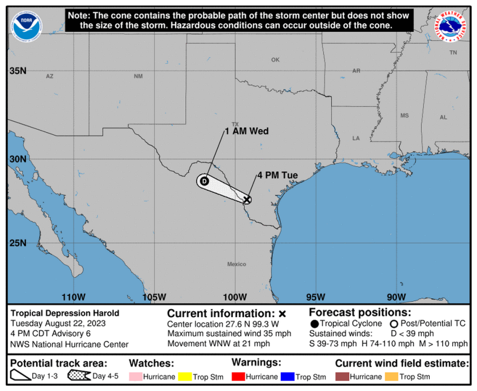
Tropical Depression 9 strengthened into Tropical Storm Harold early Tuesday morning and made landfall hours later on Padre Island in southern Texas before weakening back down to a depression. Tropical Storm Franklin, which has Haiti and the Dominican Republic in its cross hairs for later this week, could strengthen into the season’s second hurricane over the weekend.
Here are the forecasts from the National Hurricane Center 5 p.m. Tuesday update:
8/21 at 8pm: As we enter the climatological peak of the #Atlantic hurricane season, it's important for you and your loved ones to stay prepared.
Here are five simple tips to keep in mind! pic.twitter.com/UXojs8yESt— NWS Miami (@NWSMiami) August 21, 2023
What is going on with Tropical Storm Franklin?
Tuesday was a rough day for Tropical Storm Franklin. Despite a visit from a hurricane hunters plane and fierce scrutiny of radar and computer models, the hurricane center had difficulty locating the storm’s center all day Tuesday, which makes exact forecasting of the track tough.
“Franklin is not a healthy tropical cyclone — and there is still some question if it even is a tropical cyclone,” forecasters wrote.
Throughout the day, the forecast track shifted west and slowed down, holding Franklin just south of Hispaniola for longer than initially predicted. It did appear to make its northern turn on Tuesday, sending the storm on a collision course with Haiti and the Dominican Republic on Wednesday. The initial lashings of Franklin’s outermost bands could begin later Tuesday.

Forecasters said Franklin will likely get a little chopped up by the mountain range on the island, bringing the 45 mph sustained winds predicted just before landfall down to 40 mph by the time it re-exits to the north.
From there, the hurricane center said the storm will enter favorable conditions that give it the chance to strengthen into the second hurricane of the season as it veers east into the open Atlantic.
As of Tuesday evening, Tropical Storm Franklin was about 210 miles south-southwest of Santo Domingo, the capital of the Dominican Republic. It had maximum sustained winds of 40 mph and was moving northwest at 7 mph.
Most of the coast of Hispaniola, also shared by Haiti, remained under a tropical storm warning Tuesday evening. Turks and Caicos was under a tropical storm watch.
Heavy rainfall from Franklin is expected across portions of Puerto Rico and Hispaniola through the middle of the week, producing areas of flash and urban flooding as well as river rises and mudslides. Across Hispaniola, significant and potentially life-threatening flash flooding is possible Tuesday into Wednesday.
Tropical Storm Harold hits Texas
Tropical Storm Harold made landfall on Padre Island, Texas on Tuesday morning, bringing 50 mph sustained winds and several inches of rain.
The fast-moving storm, which already devolved into a tropical depression by the afternoon, was expected to head west across the state and dissolve completely by Wednesday.
Harold was expected to soak South Texas through Wednesday with three to five inches of rain and bring up to three feet of storm surge.
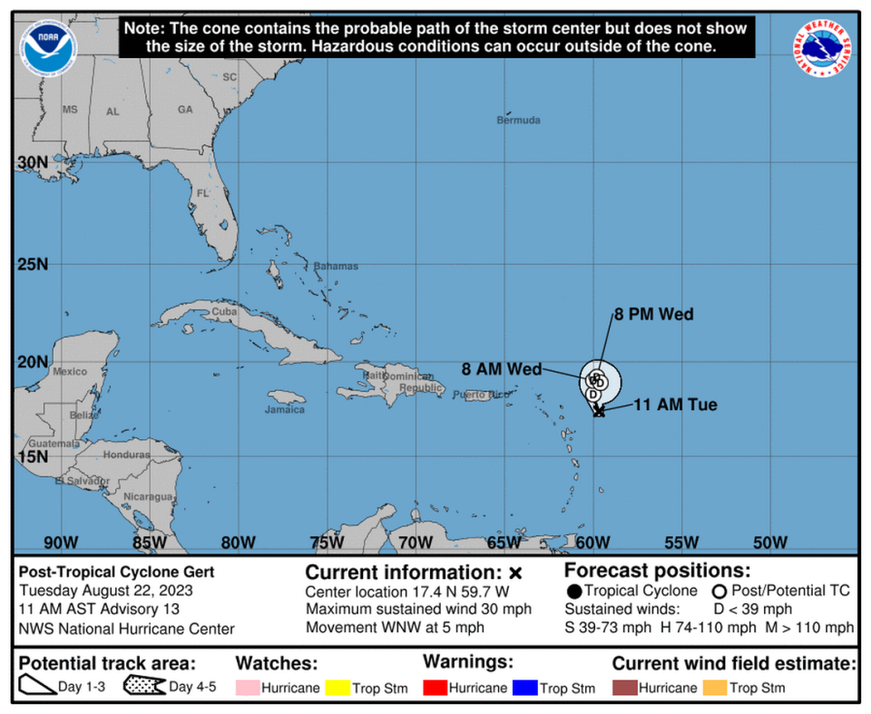
Gert and the disturbances
Tropical Depression Gert has been fading from nearly the moment it was named this weekend. It finally finished the job Tuesday mid-morning, when the hurricane center declared it a remnant low or post-tropical cyclone and issued its final advisory.
To its east, the hurricane center is tracking two other disturbances. One, former Tropical Storm Emily, was headed north, where it has a low chance of reforming anytime this week — 30%.
The other, disturbance two, saw its chances of development fall from Monday’s heights. As of Tuesday evening, forecasters gave this disorganized cluster of thunderstorms only a 10% chance of forming in the next day or two, and a 40% chance within the next week.

