Tropical Storm Franklin strengthens over open ocean as eyes turn to new disturbance
Tropical Storm Franklin broke free of land overnight, setting it on a path to strengthen into a powerful hurricane by the weekend and leaving the island of Hispaniola drenched.
While two other disturbances are churning in the east Atlantic, forecasters are carefully watching computer model runs for a new, third disturbance to the west of Central America that could hop into the Caribbean over the weekend and form in the eastern Gulf of Mexico next week.
It’s too early to know what could happen with this system, but Miami National Weather Service Meteorologist Sammy Hadi warned that Floridians should prepare for rain.
“A deep plume of tropical moisture associated with this feature could result in the potential of heavy rainfall & localized flooding across the FL peninsula,” he tweeted Thursday morning.
NHC is now highlighting a medium chance of development (50%) of a disturbance in the NW Caribbean Sea over the next 7 days. A deep plume of tropical moisture associated with this feature could result in the potential of heavy rainfall & localized flooding across the FL peninsula. pic.twitter.com/suimjFfaTA
— Sammy Hadi (@SammyHadiWx) August 24, 2023
Here are the forecasts from the National Hurricane Center’s 5 p.m. Thursday update:
Where’s Tropical Storm Franklin now?
Tropical Storm Franklin was well north of Hispaniola Thursday afternoon and on its way to strengthening into the hurricane — potentially a strong Category 2 — that forecasters have predicted.
On the island, damage assessments were still underway. Franklin made landfall near Barahona, on the Dominican Republic’s southern coast. The island saw homes flooded and at least one bridge destroyed, but no deaths have been reported.
In Haiti, authorities have lifted their countrywide warning for Franklin but continue to call for vigilance. The environmentally vulnerable country appears to have dodged a bullet, but there are concerns that with the storm’s damage to crops in communities like Aquin, already severe hunger will be on the rise.
Assessment teams will be making their way into the region and reporting back, the country’s Office of Civil Protection said. In preparation for the storm’s arrival, aide workers with the World Food Program managed to deliver emergency stocks to the Lower Artibonite Valley, just north of Port-au-Prince, where violent gangs have been escalating their fight and taking the population hostage.
As of Thursday afternoon, Franklin was 155 miles east-northeast of Grand Turk Island and moving northeast at 8 mph with maximum sustained winds of 60 mph.
Forecasters said Franklin’s slower path over more forgiving ocean conditions in the next few days should give it enough time and fuel to power up into a strong Category 2 hurricane with 110 mph sustained winds by the weekend.
Third tropical disturbance pops up
The newest tropical system is an area of low pressure that could form in a couple of days over the northwestern Caribbean Sea and head toward the eastern Gulf of Mexico. Forecasters said it most likely won’t see any change in development until the weekend.
As of Thursday afternoon, chances of doing so were at 10% in the next two days, 60% in the next seven — a slightly higher figure than earlier in the day.
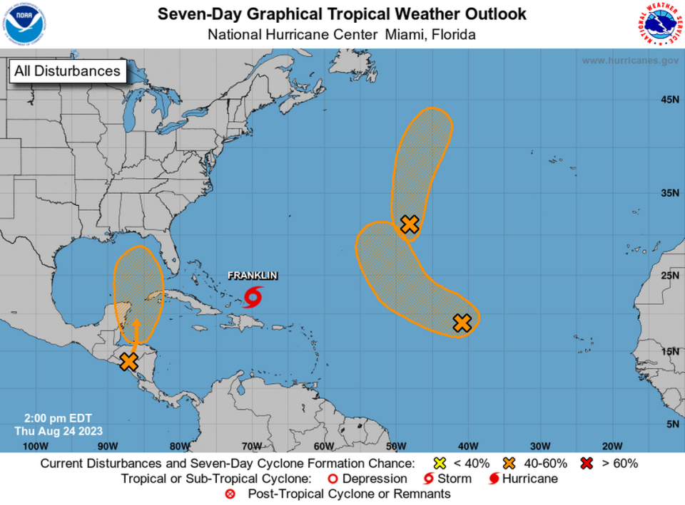
The hurricane center was still tracking the remains of former Tropical Storm Emily, which was just an area of low pressure about 1,000 miles east-southeast Bermuda as of Wednesday morning.
It could regenerate into a tropical storm by Friday. It had a 50% chance of forming in the next two or seven days, a drop from earlier in the day.
The other disturbance, another area of low pressure several hundred miles west of the Cabo Verde Islands, could become a tropical depression by the weekend. It had a 20% chance of forming in the next two days and a 50% chance in the next seven.
The next storm name on the list is Idalia.

