Tropical Storm Grace could bring floods, mudslides to Haiti before approaching South Florida
Consider Fred the clumsy big brother that got Florida’s attention focused on peak of hurricane season. Now, Grace appears to be following Fred’s path with a track toward Florida.
As Sunday’s 11 a.m. advisory, a disorganized Grace had 40 mph maximum sustained winds and was 85 miles south of San Juan, Puerto Rico.
Haiti — which suffered a major earthquake Saturday morning — as well as the Turks and Caicos Islands and southeastern Bahamas and Cuba are advised to monitor Grace’s progress, the center suggested. The government of the Dominican Republic has issued a Tropical Storm Warning from Cabo Caucedo to the southern Haitian Border.
If Grace passes near or over Haiti Monday night, four to seven inches of rain could fall on the battered island, with isolated totals reaching 10 inches. This much rain could lead to flash flooding and potential mudslides from Monday into Tuesday, the hurricane center warned.
Miami-Dade Emergency Management officials also noted that Tropical Storm Grace has the county — and South Florida — in its five-day cone of uncertainty.
Meanwhile, disorganized Fred strengthened early Sunday and is back to a tropical storm in the Gulf of Mexico. Warnings will be posted for the northern Gulf Coast.
Will Grace be a wrecking ball or merely a wreck of a system?
“There is no consensus on impacts to South Florida from Grace due to its forecast interaction with several land masses in the Carribean,” Miami-Dade EM tweeted Saturday morning.
#MiamiDadeEM is monitoring Tropical Storm #Grace. #OurCounty is within the 5-Day Cone of uncertainty. There is no consensus on impacts to South Florida from Grace due to its forecast interaction with several land masses in the Carribean. pic.twitter.com/5M8Hzbw3e9
— Miami-Dade County EM (@MiamiDadeEM) August 14, 2021
Where is Grace going?
In its 11 a.m. Sunday advisory, the hurricane center put Grace 85 miles south of San Juan, Puerto Rico and and 270 miles east-southeast of Santo Domino, Dominican Republic The storm is moving west-northwest at 16 mph.
Tropical storm-force winds extend outward up to 35 miles from the center, according to the hurricane center.
On the forecast track, Grace is expected to pass through the Leeward Islands and near the Virgin Islands and Puerto Rico on Sunday, near or over the Dominican Republic Sunday night and Monday, and then near or over Haiti Monday night.
These areas could see three to six inches of rain associated with this storm and eight inches in isolated areas. “Heavy rainfall” from Grace could impact Florida late next week, the center said.
SATURDAY 8AM ADVISORY: Tropical Storm Grace is quickly moving westwards towards the Leeward Islands. A decrease in forward speed is expected in the next few days. Tropical Storm warning now in effect for the British Virgin Islands. @wsvn pic.twitter.com/OIKQDJRQEU
— Erika Delgado (@ErikaDelgadoWx) August 14, 2021
Grace is expected to strengthen Sunday but is likely to weaken while it moves near and across the Greater Antilles Sunday night through Monday night, the hurricane center said.
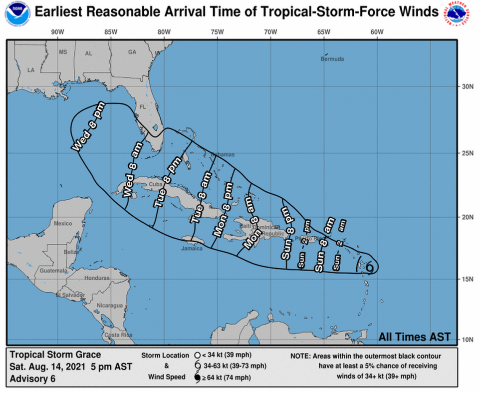
In its Saturday afternoon map, the National Hurricane Center puts the earliest arrival of tropical storm-force winds near South Florida’s coast, which also includes the Keys, some time early Wednesday morning. But, note, much can change as Grace reacts with land and other atmospheric factors on its current track.
“Much like Fred before it, Grace has many obstacles ahead including dry air, some wind shear and possible land interaction,” CBS4 meteorologist Craig Setzer said on Twitter Saturday. Later Monday could bring a clearer picture on Grace’s potential interaction with Florida, he said.
TD #7 upgraded to tropical storm Grace this morning. Much like Fred before it, Grace has many obstacles ahead including dry air, some wind shear, & possible land interaction. We will have to keep a close watch on Grace after Monday to get an idea of possible Florida impacts. pic.twitter.com/A3K7nZyMXY
— Craig Setzer (@CraigSetzer) August 14, 2021
Currently, the National Weather Service in Miami forecasts an 80% chance of rain, with thunderstorms, for South Florida starting Tuesday through Thursday.
Tropical storm warnings, watches
The hurricane center issued several tropical storm warnings and watches.
A Tropical Storm Warning is in effect for:
▪ U.S. Virgin Islands
▪ Puerto Rico, including Vieques and Culebra
▪ Dominican Republic from the southern Haitian border to Samana
A Tropical Storm Watch is in effect for:
▪ North coast of the Dominican Republic from the Haitian border to Samana
▪ Entire coast of Haiti
And here we have Tropical Storm #Grace, the 7th named storm of the season. This is 20 days ahead of the average 7th named storm formation date. Others seasons to reach this mark by August 13th during the satellite era: 2020, 2017, 2005, 1995. pic.twitter.com/uUmwl6Uc2j
— Brian McNoldy (@BMcNoldy) August 14, 2021
Aug 14 @ 5am - Here's the latest on Tropical Depression #Fred and newly named Tropical Storm #Grace. Periods of heavy rain expected from Fred today into tonight. Too early to discuss potential impacts from Grace but continue to monitor. #flwx pic.twitter.com/VNwwdG8MHD
— NWS Miami (@NWSMiami) August 14, 2021

