Hurricane Grace heads to Mexico. Tropical Storm Henri expected to strengthen, too
Hurricane Grace, a wider, faster and stronger storm, continued toward Mexico’s Yucatan peninsula Wednesday, where it’s expected to make landfall early Thursday.
Forecasters are also eyeing Tropical Storm Henri, which could strengthen into a hurricane by the weekend as it moves over the Atlantic. Neither storm is a threat to Florida.
Here’s what else know:
Hurricane Grace continues toward Mexico
Strong winds and a dangerous storm are expected to come to portions of the eastern Yucatan Peninsula of Mexico as Hurricane Grace moved rapidly west-northwest at 16 mph with maximum sustained winds near 80 mph with higher gusts.
The storm was about 170 miles east of Tulum, Mexico, according to the National Hurricane Center’s 8 p.m. advisory. Its tropical-storm-force winds now extend up to 140 miles from its center and hurricane-force winds extend outward up to 15 miles.

On the forecast track, Grace is expected to make landfall in the eastern Yucatan Peninsula Thursday morning, move over the Yucatan Peninsula on Thursday, and move over the southwest Gulf of Mexico Thursday night or early Friday.
Weakening will occur while the center moves over the Yucatan Peninsula on Thursday, with restrengthening expected when Grace moves over the southwest Gulf of Mexico on Friday.
As of the 8 p.m. advisory, the Cayman Islands have discontinued the tropical storm warning for the islands.
A hurricane warning is in effect for the Yucatan Peninsula of Mexico from Cancun to Punta Herrero, including Cozumel.
A tropical storm warning is in effect for the Yucatan Peninsula of Mexico from north of Cancun to Campeche; theYucatan Peninsula of Mexico from south of Punta Herrero to Puerto Costa Maya.
A Tropical Storm Watch is in effect for the southern coast Cuban province of Pinar del Rio, as well as Islade la Juventud.
Tropical Storm Henri could turn into a hurricane soon
A stronger Tropical Storm Henri was moving west in the Atlantic waters between the U.S. southeast coast and Bermuda and could bring life-threatening surf and rip current conditions along the southeast and mid-Atlantic coast by the end of the week, according to the hurricane center.
As of the 11 a.m. Wednesday advisory, the storm was about 190 miles southwest of Bermuda with maximum sustained winds near 65 mph, with higher gusts, early Wednesday. Its tropical-storm-force winds extended up to 80 miles from its center.
Bermuda is no longer under a tropical storm watch, though tropical storm conditions may still be felt across the island Wednesday night, particularly to the south of the island.
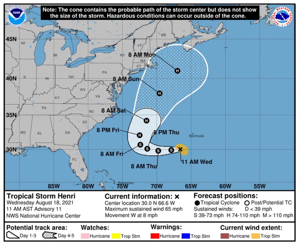
On the forecast track, Henri is forecast to make a gradual turn to the west-northwest by late Thursday, followed by another turn north and then northeast this weekend. Forecasters expect it will strengthen into a Category 1 hurricane with maximum sustained winds near 75 mph as soon as Friday.
It could see some additional strengthening as it moves across the Atlantic. However, forecasters caution that there is some uncertainty with its track later in the week, with one model showing Henri moving more north toward the New England coast.
“Due to the increased uncertainty in the track forecast, interests along the New England coast should monitor the progress of Henri,” forecasters wrote.

