Tropical Storm Ian to be major hurricane but weaken before Florida landfall late in week
Tropical Storm Ian bided its time Sunday as it steamed toward western Cuba and the virgin waters of the Gulf of Mexico with nothing to limit a volatile strengthening through mid-week.
Untouched by a tropical cyclone this season, Gulf waters remain deeply warm and nourishing for a storm expected to reach Category 4 muscle before weakening some ahead of an early Friday landfall anywhere from Pensacola to Port Charlotte.
Sunday evening, a tropical storm watch was issued for the lower Florida Keys.
National Hurricane Center meteorologists emphasized “significant uncertainty” in Ian’s 5-day track with the American, or GFS, model taking it on a more westerly route into the Panhandle and the European model aiming it more east toward Florida's west coast.
As of the 5 p.m. advisory Sunday from the hurricane center, Ian was a 45-mph tropical storm 495 miles southeast of the western tip of Cuba. It was moving west-northwest at 12 mph.
More: How early is too early to start preparing for hurricane season in Florida?
More: Hurricane preparation: What supplies do you need for a storm? Here's a list
More: Hurricane season in Florida: Watches and warnings. Why you should know the difference
It was forecast to reach hurricane strength Sunday night or Monday after stumbling around Sunday, possibly ingesting torrid air. But it is still expected to rapidly intensify with winds increasing by 55 mph between Monday morning and Tuesday when it reaches Cuba's coast as a 120 mph storm.
Emergency management officials noted that although Ian may deflate to a Category 1 if it steers toward the Panhandle, the storm surge along the shallow shores of the Gulf Coast could still be that of a major hurricane.
A track that takes Ian into Florida's fringy west coast could have it missing storm-dampening dry air gushing in with a dip in the jet stream, meaning wind speeds may not weaken as much as if it heads toward the Panhandle.
Also, areas on Ian’s periphery, including Palm Beach County, may experience rain squalls, tornadoes and possible coastal flooding. Palm Beach County is expected to be on Ian’s chaotic right side, a similar position to where it was during 2017’s Hurricane Irma when 12 tornado warnings were issued.
“Right now in southeast Florida, you will miss out on the worst of the storm,” said AccuWeather senior meteorologist Dan Pydynowski. “But certainly, there could be some impacts.”
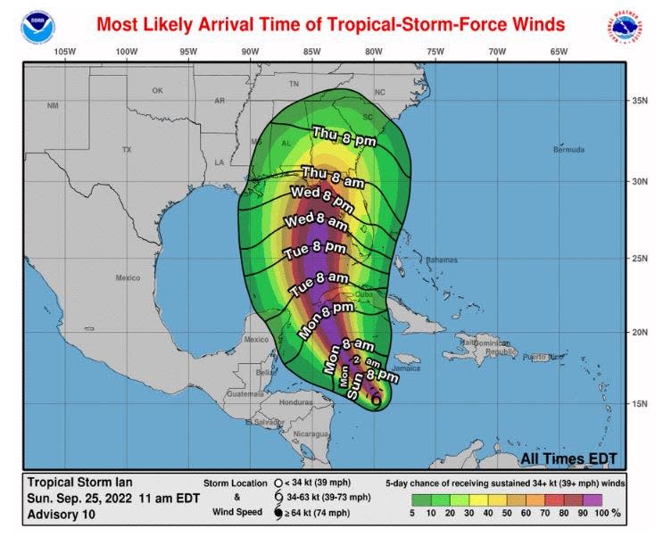
About 30% of the time, the storm travels outside the forecast cone, and effects can be felt far afield of the storm's center. Gusty winds to tropical storm force are possible beginning Tuesday afternoon in Palm Beach County, cautioned meteorologists with the National Weather Service in Miami.
In the Panhandle town of Mexico Beach, which was decimated by Hurricane Michael’s storm surge in 2018, Shell Shack owner Theresa Hunter was taking Ian in stride on Sunday.
“I don’t have any concerns right now and we haven’t done any preparations yet,” said Hunter, whose family has owned the novelty and seafood store since 1965. “I’ve lived here my whole life, and in my 56 years, I’ve only evacuated four times.”
During Category 5 Michael, Hunter was staying with family in Wewahitchka, about 18 miles inland. It took two years to reopen her store after storm surge crushed most of the town.
“We are watching (Ian),” Hunter said. “It’s just something you have to deal with.”
More: 'It's not over yet': Florida vulnerable to hurricanes in October; where to watch as month begins
More: Devastating Michael could signal death of a beach town
More: Your guide to the 2022 hurricane season in Florida
Gov. Ron DeSantis on Saturday expanded a "state of emergency" to all 67 Florida counties in preparation for Ian. During a press conference Sunday, Florida Division of Emergency Management Director Kevin Guthrie said he has already requested help from urban search and rescue teams from other states and that FEMA medical transport units are on their way to Orlando. About 2,500 Florida National Guardsmen have also been activated.
Guthrie asked residents to determine if they live in an evacuation zone and avoid evacuating if they don’t. Florida evacuates based on storm surge heights, not wind speeds. Evacuations zones statewide can be found at www.floridadisaster.org/knowyourzone.
“In Hurricane Irma we over-evacuated residents by nearly 2 million people,” said Guthrie, who also warned people should prepare to lose electricity and anticipate disruptions at gas stations. “You may lose power for multiple days.”
The National Weather Service asked some of its 120 forecast offices nationwide to launch extra balloons to get a better assessment of the atmosphere ahead of Ian, and NOAA's high-altitude Gulfstream jet began flights Saturday.
Fun fact: @NHC_Atlantic has asked many offices to do 4 balloon launches daily (instead of the usual 2) over the next several days to help better forecast Tropical Storm Ian. This includes us & many of our neighboring offices out here in the PNW! #wawx pic.twitter.com/11JAUxlLtW
— NWS Seattle (@NWSSeattle) September 24, 2022
Florida Power & Light activated its emergency response plan Sunday, sending out workers ahead of the storm so they could respond quickly to power failures.
"FPL operates tens of thousands of miles of overhead power lines surrounded by millions of trees," said FPL Chairman and CEO Eric Silagy. "Storms like this are nature’s way of clearing debris, and it is likely that vegetation and other debris will cause outages and restoration challenges."
Kathy Helmus, who lives on the beach in Indian Shores, south of Clearwater, said on Sunday she is watching Ian but not overly worried. Her home is raised 17 feet and was built in 2015 to withstand 220-mph winds.
Helmus said she’ll bring in outdoor furniture and evacuate if there is a storm surge threat to protect her cars.
“Thankfully in Pinellas County we have missed a lot of the bad impacts from hurricanes,” Helmus said. “We’ve done everything we can to protect ourselves and we just go one day at a time.”
Ian is forecast to be a 120-mph Category 3 hurricane when it reaches Cuba’s far western coast. By Tuesday morning, it is expected to reach 130-mph sustained winds north of the island, making it a Category 4 hurricane.
It is expected to maintain Cat 4 strength into Wednesday, but then dip to a 110-mph Category 2 hurricane Thursday as it begins to gulp dry air from the dip in the jet stream and upper-level wind shear tears at its circulations.
“The unresolved question is whether the system hangs a right and comes ashore (along the west coast of Florida) as a powerful storm before the environmental regime changes,” said meteorologist Bryan Norcross in his Hurricane Intel blog. “Does the weakening occur over the ocean or over the Florida peninsula? That's unknown.”
This article originally appeared on Palm Beach Post: Ian expected to be major hurricane then weaken before landfall

