Tropical Storm Iota nearly a hurricane. Aimed to hit Central America as category 3 storm
Tropical Storm Iota is almost a hurricane, triggering hurricane warnings along the coast of Nicaragua and Honduras, the National Hurricane Center said.
Iota became the 30th named storm in a record-breaking hurricane season after forming in the central Caribbean Sea Friday. The storm is still forecast to hit Central America as a hurricane. The region is already reeling from Eta hitting Nicaragua as a Category 4 hurricane last week.
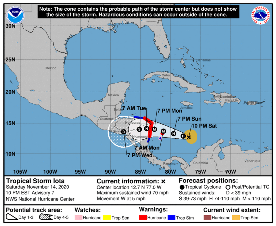
Iota was moving west at 5 mph with maximum sustained winds of 70 mph with higher gusts, according to the National Hurricane Center’s 10 p.m. advisory Saturday.
It was about 365 miles south of Kingston, Jamaica, and about 445 miles east-southeast of Cabo Gracias A Dios on the Nicaragua/Honduras border.
A westward motion with some increase in forward speed was expected to continue through Monday, according to the center.
Warnings, watches
The governments of Nicaragua and Honduras have upgraded their hurricane watches to hurricane warnings.
In Nicaragua, the warning is in effect from Sandy Bay Sirpi to the Honduras/Nicaragua border. A tropical storm warning was also issued from Sandy Bay Sirpi to Bluefields.
In Honduras the warning is in effect from the Honduras/Nicaragua border to Punta Patuca. Honduras has also upgraded the tropical storm watch to a tropical storm warning from Punta Patuca to Punta Castilla.
The government of Colombia issued a hurricane warning for the island of Providencia.
Tropical storm-force winds extended about 105 miles from the center.
Iota continues 2020’s streak of most storms recorded in modern history. The previous record was in 2005 with 28 storms, including the devastating Hurricane Katrina. This year’s season broke the record Monday night, when Tropical Storm Theta formed in the Atlantic.
“Iota is expected to intensify and be a major hurricane when it approaches the coast of Central America,” forecasters wrote.
The hurricane center’s interactive forecast track shows Iota having maximum sustained winds of 125 mph by Monday when it nears the coast of Nicaragua and Honduras. That would make it a Category 3 hurricane.
Its forecast track is similar to Eta’s, which hit Nicaragua as a Category 4 hurricane last week and caused widespread destruction there and in neighboring Honduras. About 1.2 million children have been affected by the storms in Central America, UNICEF said this week.
Tropical Storm #Iota is strengthening over the south-central Caribbean Sea. Here are the Key Messages from the 4 pm EST advisory. For more info, visit https://t.co/tW4KeGdBFb pic.twitter.com/MTPM3M6NJr
— National Hurricane Center (@NHC_Atlantic) November 14, 2020
Iota’s forecast track
On the forecast track, Iota will move across the southwest Caribbean Sea tonight and Sunday, pass near or over Providencia island on Monday and approach the coasts of Nicaragua and northeastern Honduras Monday evening, according to the hurricane center.
The NHC said it expected the system to see significant strengthening during the next 24 to 72 hours, enough to turn it into a major hurricane in a few days. Forecasters say the system should weaken once it is over land but that if a more northern track occurs, keeping it over water, it could become stronger.
When will South Florida dry out? Things must be looking up based on this adorable tweet
How much rain?
The hurricane center predicts that the system will produce 8 to 16 inches of rain across Honduras and northern Nicaragua, with isolated maximum totals of 20 to 30 inches.
Across Costa Rica, Panama, and northern Colombia, southern Nicaragua, Belize, Guatemala and El Salvador, forecaster predict 4 to 8 inches of rain, with some areas possibly seeing up to 12 inches.
“This rainfall would lead to significant, life-threatening flash flooding and river flooding, along with landslides in areas of higher terrain,” forecasters wrote.
Jamaica and southern Haiti may see 1 to 3 inches of rain, forecasters say.
Record number of storms
NOAA predicted this would be an above-average season early on, and midseason it upped its expectations to call for the highest number of storms it had ever predicted — 25.
But 2020 blew through that in mid-October.
This year is also the second time the Greek alphabet has been used to name storms after the regular alphabetical list was exhausted.
And in case you’re wondering about Eta, which also struck Cuba and Florida as a tropical storm, it became an extratropical low Friday morning about 85 miles southeast of Wilmington, North Carolina.
The National Hurricane Center issued its last advisory on Eta at 4 a.m. Friday and said it would move into the Atlantic’s open waters, where it will be absorbed by a larger non-tropical cyclone on Saturday or Saturday night.
Hurricane season ends on Nov. 30.
Miami Herald staff writer Alex Harris contributed to this report.

