Tropical Storm Isaias crossing Dominican Republic with South Florida still in cone
Tropical Storm Isaias is nearly done crossing the Dominican Republic, and the impacts South Florida and the Bahamas could see depend on what happens as the storm crosses the island’s high mountains.
Isaias is about 85 miles southeast of the northern tip of the Dominican Republic, Puerto Plata, according to the National Hurricane Center’s 5 p.m. update.
By Thursday afternoon, Isaias’ journey overland already started to take a toll. The storm contracted, with tropical-storm-force winds now stretching up to 310 miles out from the center as opposed to Thursday morning’s 415 miles. It maintained 60 mph winds and its speed of 20 mph.
The last few updates have shifted the track east, with the core of the storm passing between South Florida and the northern Bahamas on Saturday, but forecasters said it will be hard to know which way the storm will head until it has passed through Hispaniola.
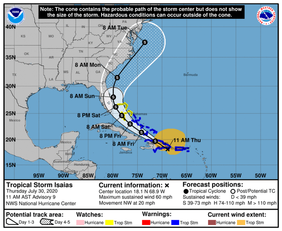
The center of Isaias is forecast to move diagonally across Hispaniola’s storm-shredding mountain range on Thursday, making landfall on the southeastern edge and emerging near the northern border of Haiti and the Dominican Republic. The storm is disorganized and still lacks a clearly defined center, which is what forecasters use to track the storm, so it’s hard to tell what shape it’ll be in when it enters open ocean again.
“There’s a great deal of uncertainty, and today’s not going to provide a whole lot more certainty,” said Joel Cline, tropical program coordinator at NOAA’s weather service headquarters. “We’ll know a lot more tomorrow.”
NHC forecasters predict Isaias may restrengthen Friday as it re-enters the ocean, but its exact track is still unclear.
“Anywhere from the outer banks to the Florida Keys needs to really pay attention to this today and tomorrow. Prepare for the worst and hope for the best,” Cline said.
As of 11 a.m. Thursday, the National Hurricane Center was predicting that South Florida could see between 65 and 70-mph winds as the storm nears the coast of Florida this weekend, although it said predicting the intensity of the storm is “challenging.”
“There are models that continue to suggest Isaias could become a hurricane when it is near the U.S., but given the continued uncertainty, the NHC intensity forecast remains near the intensity consensus,” forecasters wrote.
The NHC predicted Miami has about a 26 percent chance of seeing tropical-storm-force winds (at least 39 mph) on Saturday, while Ft. Lauderdale and Palm Beach have a 42 percent chance. The chances go up slightly for all three locations on Sunday.
Marathon and Key West have a 14 and 7 percent chance, respectively.
Preparing for Isaias
Miami-Dade has no plans to open hurricane shelters at this time, a process usually triggered by storm surge. “At this point, there is no significant storm surge anticipated for Miami-Dade,” said Emergency Management Director Frank Rollason.
The state said Wednesday it has no current plans to open shelters either, according to Jason Mahon, spokesperson for Florida’s Department of Emergency Management.
“We have 20 shelters basically on stand-by. We’ve sent the equipment that’s needed to open them,” Mayor Carlos Gimenez said in an online press conference Thursday from the county’s Emergency Operations center in Doral.” But at this point, we’re not opening them.. We may pull the trigger on opening some shelters, depending on the forecast strength and the direction.”
Gimenez said Thursday the county is closing all county parks, marinas and golf courses Friday night. He said the region expects three to five inches of rain.
Roman Gastesi, Monroe County administrator, said the Keys will likely close to visitors Friday afternoon.
“We can probably make that determination later today or tomorrow morning,” Gastesi said during a Thursday morning conference call with other county and municipal officials Thursday morning.
The latest forecast from the National Weather Service was promising for the Keys, showing the storm progressing up the coast farther east than forecasters predicted yesterday.
Here’s the 411 on storm preparation in the COVID-19 era and beyond — just in case
If Isaias strengthens as it heads over the Florida Straits, that will be good news for the Keys and South Florida because it means the center will likely stay east of the region, said John Rizzo, warning coordinator meteorologist at National Weather Service Key West.
If it leaves Hispaniola disorganized, the conditions over the Keys are expected to be more dangerous, Rizzo said.
“Only if it weakens do we see strong squalls over the Florida Keys,” Rizzo said.
Isaias’ trail of damage
In Port-de-Paix in Haiti’s northwest region, tops were blown off houses by Isaias’ gusty winds and rains that came on and off throughout the day. The outdoor markets were closed and the wooden sloops that normally transport Haitians between the city and the island of Île de la Tortue also ceased operation due to the rough seas. Making the day equally difficult for many in the city is a shortage of fuel that paralyzed public transport.
Through Wednesday night, Puerto Rico saw more power outages, mudslides and flooding.
The island’s southern region, which is still being shaken by earthquakes, was hit especially hard. Santos Seda, mayor of the southwest town of Guánica, told The Associated Press that he has received reports of downed trees and inundated neighborhoods where earthquake-damaged homes still stand.
“The emotional state of people is deteriorating more every day,” he said.
In Puerto Rico, Isaías’ heavy rain flooded streets and homes and caused landslides that blocked mountain roads. Municipalities in the center of the Island like Aguas Buenas and Aibonito saw water levels rise in rivers and cause flash flooding. Close to the coast in Mayaguez, the rain accumulation caused the Yaguez river to flood the town in residential areas leaving thousands of homes underwater.
The 60 mph winds and higher gusts blew over trees and power lines, causing major blackouts around the island. According to the Electric Energy Authority of Puerto Rico, around 400,00 families were without power Thursday morning, which represents 25 percent of its clients.
Tropical Storm Watches/Warnings
Tropical storm warnings for St. Martin, St. Barthelemy, St. Maarten, Saba, St. Eustatius, Puerto Rico and the U.S. and British Virgin Islands were discontinued Thursday.
Warnings are still in effect for the Dominican Republic’s entire southern and northern coastlines. Warnings are also in effect along the north coast of Haiti from Le Mole, St. Nicholas eastward to the northern border with the Dominican Republic, Turks and Caicos Islands, the southeastern and central Bahamas.
Tropical storm watches are in effect for the Northwestern Bahamas including Andros Island, New Providence, Eleuthera, Abacos Islands, Berry Islands, Grand Bahamas Island and Bimini.
Forecasters say those in Cuba and Florida should continue monitoring the progress of the storm.
St. Kitts and Nevis, located in the Caribbean, said Wednesday that neither island sustained any injuries or deaths as Tropical Cyclone 9, which formed into Tropical Storm Isaias, passed about 123 miles south-southwest of the islands. The islands discontinued all tropical storm watches and warnings and are reopening closed businesses Thursday.
el Nuevo Herald writer Salomé Ramírez Vargas contributed to this report.

