Tropical Storm Karl starting to move southeast toward Mexico. NHC watching new tropical wave
The National Hurricane Center is tracking two systems, including Tropical Storm Karl in the Gulf of Mexico.
Karl was starting to move after being stationary in the southwestern Gulf of Mexico. Sustained winds remain at 50 mph, according to the latest advisory from the National Hurricane Center.
Karl is forecast to weaken before landfall. The latest track shows the center of Karl reaching the Mexican coast in Tabasco or Veracruz states by Saturday morning.
► Your guide to preparing for the 2022 hurricane season in Florida
Karl is not expected to become a direct threat to the United States if it does take the forecasted southward turn toward Mexico.
However, moisture associated with the system could drift north and bring more rain and thunderstorms from southeastern Texas to Louisiana and potentially into Arkansas Sunday to Tuesday, according to AccuWeather.
Oct 13: Here's a look at Tropical Storm #Karl this morning. Seas are currently 14-16 ft in the Bay of Campeche near the center of the storm. Find more information in our offshore waters forecast: https://t.co/nxRBorjwxp pic.twitter.com/idKmSyHQLo
— NHC_TAFB (@NHC_TAFB) October 13, 2022
AccuWeather forecasters warned Karl could strengthen in the short term.
"There is also a bubble of high pressure in the upper portion of the atmosphere right over the top of the zone, which could allow more thunderstorms to erupt and strengthen into Thursday," AccuWeather Chief On-Air Meteorologist Bernie Rayno said.
Warm water in the area also could lead to some strengthening. At this time, Karl is not expected to become a hurricane before making landfall.
Elsewhere in the Atlantic basin, forecasters are watching a tropical wave off the African coast south of Cabo Verde Islands.
The system currently has a 20 percent chance of development over the next five days.
WeatherTiger: Mid-October Florida hurricane forecast: Odds tilt in our favor after brutal Ian
'Cost for living in paradise': After Hurricane Ian, will Florida residents build back better?
Storm costs: Was Hurricane Ian the most expensive hurricane to hit Florida? Where Category 4 storm ranks
Rebuilding after Ian: Is climate change to blame for more hurricanes? Experts remain split
Here's the latest update from the NHC as of 5 a.m. Oct. 13:
Tropical Storm Karl
Location: 837 miles west of Naples; 250 miles north-northeast of Veracruz, Mexico
Maximum wind speed: 50 mph
Direction: southeast at 2 mph
Next advisory: 11 a.m.
At 8 a.m., the center of Tropical Storm Karl was located 837 miles west of Naples 250 miles north-northeast of Veracruz, Mexico.
Karl is moving toward the southeast near 2 mph. A slightly faster southeastward motion is expected later today. Karl is then expected to turn southward or south-southwestward over the Bay of Campeche on Friday.
On the forecast track, the center of Karl should reach the coasts of Tabasco or Veracruz states in Mexico late Friday night or early Saturday.
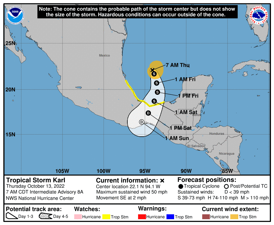
The new track shows the center of Karl reaching the Mexican coast in Tabasco or Veracruz states by Saturday morning.
Maximum sustained winds are near 50 mph, with higher gusts.
Ian's power left lasting damage: Photos reveal how Hurricane Ian flooded, pummeled and destroyed parts of Florida
Little change in strength is expected today, but Karl should gradually lose some strength on Friday while it approaches the Bay of Campeche coast of Mexico.
Tropical-storm-force winds extend outward up to 90 miles from the center.
What's out there and where is it?
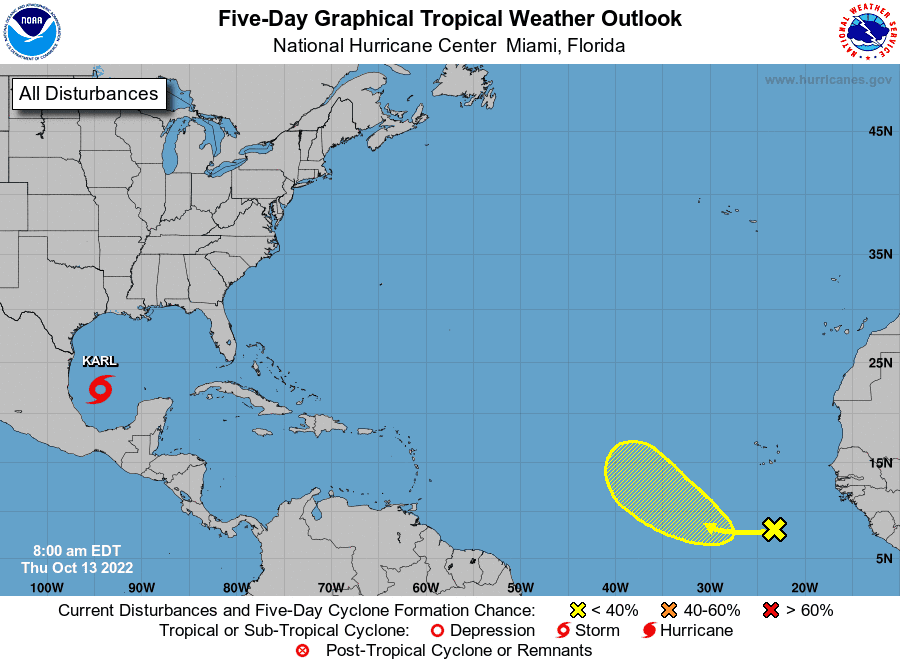
A large area of disorganized showers and thunderstorms located several hundred miles south of the Cabo Verde Islands is associated with a tropical wave.
How likely is it to strengthen?
Environmental conditions appear marginally favorable for some slow development of this system as it moves westward to west-northwestward at 5 to 10 mph over the tropical Atlantic through early next week.
Formation chance through 48 hours: low., near 0 percent.
Formation chance through 5 days: low, 20 percent.
Who is likely to be impacted?
Tropical Storm Karl: Heavy rainfall associated with Karl could produce flash flooding, with mudslides in areas of higher terrain, across portions of Veracruz, Tabasco, Chiapas and Oaxaca states in Mexico.
Tropical storm conditions are possible in the watch area in Mexico beginning late Friday or early Saturday.
Tropical wave: It's too early at this time to determine if there will be any impact to the U.S. from the tropical wave.
Forecasters urge all residents to continue monitoring the tropics and to always be prepared during what's expected to be an active hurricane season.
When is the Atlantic hurricane season?
The Atlantic hurricane season runs from June 1 through Nov. 30.
When is the peak of hurricane season?
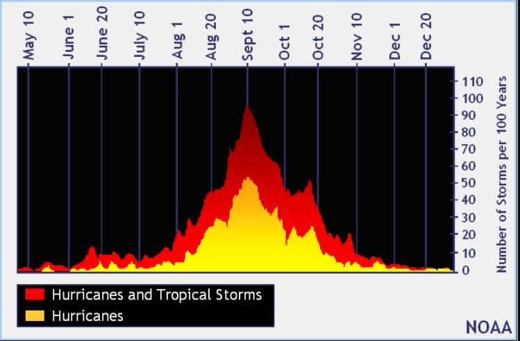
Although the season has gotten off to a quiet start, the peak of the season is Sept. 10, with the most activity happening between mid-August and mid-October, according to the Hurricane Center.
Weather watches and warnings issued for your area
If you can't see any local weather warnings here, you'll need to open this story in a web browser.
Tropical forecast over next five days
See the National Hurricane Center's five-day graphical tropical weather outlook below.
Excessive rainfall forecast
What's out there?
Systems currently being monitored by the National Hurricane Center.
What's next?
We will continue to update our tropical weather coverage daily. Download your local site's app to ensure you're always connected to the news. And look at our special subscription offers here.
This article originally appeared on Naples Daily News: Tropical Storm Karl: NHC forecasts no strengthening before landfall

