Tropical storm warning issued for the Florida Keys as Laura dumps heavy rains on Cuba
Despite the threat of twin storms on the horizon— one already leaving a trail of flooding and death in the Caribbean — Florida appeared likely to escape with little more than a side-swipe of strong winds.
But forecasters early Monday issued a tropical storm warning for parts of the Keys as Tropical Storm Laura makes its way through the Caribbean. The warning affects the middle and lower Keys from Craig Key to Key West.
Tropical-storm-force winds are expected in the lower and middle Keys later Monday, “particularly during squalls associated with passing rain bands,” according to the National Weather Service. The weather service forecasts the area will see winds ranging between 25 to 35 mph and gusts going as high as 45 to 50 mph in squalls.
5 AM, 8/24/2020: Tropical Storm Warning expanded to include the Lower/Middle #FloridaKeys.
Tropical Storm-force winds are expected in these areas this afternoon and tonight, particularly during squalls associated with passing rainbands. #flwx #FLKeys #KeyWest #MarathonFL #Laura pic.twitter.com/TtAHvKEn0O— NWS Key West (@NWSKeyWest) August 24, 2020
The National Hurricane Center expected the dual storms to wallop the coastlines of Louisiana and Texas mere days apart — starting with Tropical Storm Marco on Tuesday and Tropical Storm Laura, expected to strengthen to at least to a category 2 hurricane, on Wednesday.
A possible reprieve for the northwestern Gulf: Marco weakened from a hurricane to a tropical storm late Sunday night, and forecasters said it might not re-strengthen.
As of Sunday, Laura had already killed at least 13 people in Haiti and the Dominican Republic, left more than a million Dominicans without power and caused mudslides in Puerto Rico. It was just beginning to pound the southeastern tip of Cuba on Sunday afternoon and is expected to strengthen considerably as it fuels up on the steamy waters of the Gulf of Mexico.
“Although not explicitly shown, Laura could threaten the northwestern Gulf coast near major hurricane strength,” forecasters warned.
The hurricane center’s forecasts throughout the day reflected a growing danger for the Gulf Coast and a lessening one for Florida. The tropical storm watch for Florida Bay and the Keys north of Craig Key was discontinued as of the 5 p.m. update, and Monroe County pulled back its mandatory evacuation orders for residents of mobile homes and boats Sunday morning.
Listen to today's top stories from the Miami Herald:
Subscribe: Apple Podcasts | Spotify | Amazon Alexa | Google Assistant | More options
Tropical Storm Laura
Tropical Storm Laura spent Sunday crossing the gap between Haiti and Cuba, and those warm waters helped strengthen the quick-moving storm. From Sunday afternoon to evening, its maximum winds climbed from 50 mph to 65 mph with higher gusts.
It also kept to the southern end of Hispaniola on Saturday, avoiding serious impacts from the hurricane-shredding mountains on the island while doling out tremendous amounts of rain that caused flash flooding around the island. On Sunday evening, Laura appeared poised to follow a similar track through Cuba, staying mostly over the warm waters to the south of the island.
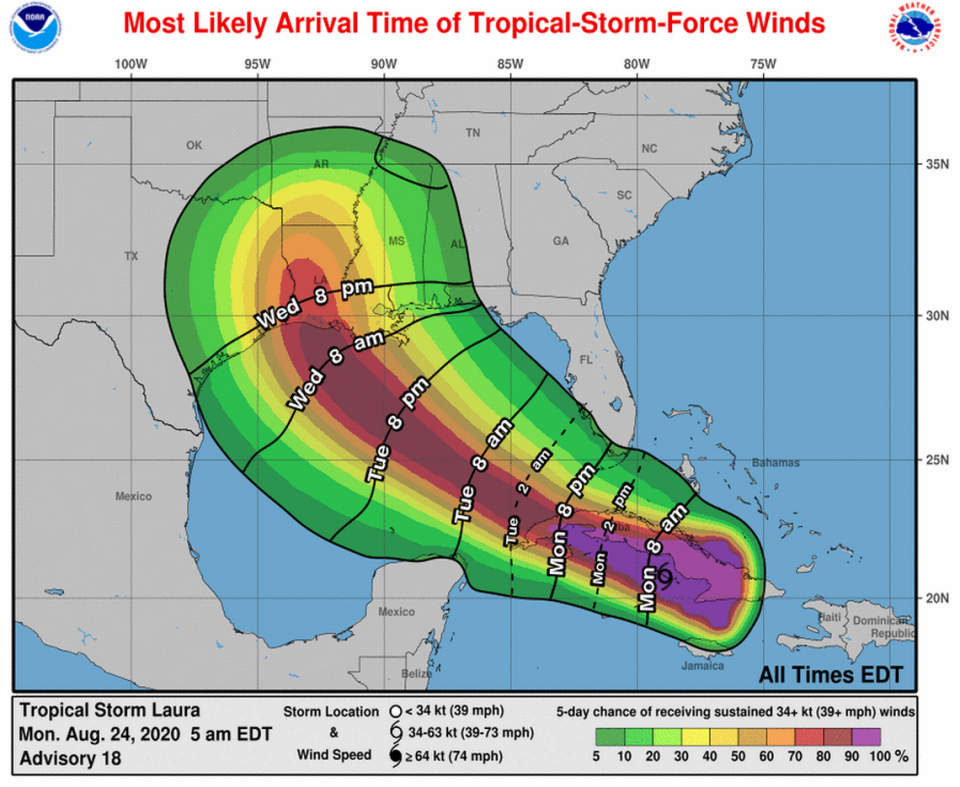
After it clears Cuba Tuesday morning, Laura is expected to rapidly strengthen to a high-level category 2 hurricane before making landfall somewhere in Texas or Louisiana Wednesday evening.
“The details of the northwest and north turn are quite important when trying to figure out where the core of Laura is going to make landfall. However, at this time there is still a notable spread in the models and their ensemble members, meaning that it is still unclear exactly where the worst weather conditions will occur,” forecasters wrote.
As of 8 a.m. Monday, Laura was 125 miles east-southeast of Cayo Largo, Cuba, and headed west-northwest at 21 mph.

Like Haiti and the Dominican Republic, Cuba is expected to see four to eight inches of rain, with a full foot in some places.
The forecast track for Laura shows mainland Florida outside its path and only a portion of the Florida Keys in the cone. Although tropical-storm-force winds extend 175 miles from the center, mainly to the north, mainland South Florida has a low chance of seeing serious winds.
“The chance for sustained Tropical Storm conditions has become less likely,” the National Weather Service in Miami said Sunday.
The weather center said Sunday afternoon that there’s about a 5 to 10% probability that the Gulf Coast and far southern Miami-Dade County will experience tropical-storm-force winds, defined as sustained winds of up to 73 mph. For the rest of South Florida, the chances are 5%.
The chances are closer to 20% in Key West, according to the hurricane center.
Despite the chance for rough weather, in Key West, many locals went to work or spent a day off at the beach or around the house to escape the muggy, hot weather and bright sunshine.
Those who live on boats, though, were preparing for severe weather on Sunday.
“Basically getting all the ropes tied down and helping all the neighbors,” said Shannon Gaytan, who lives on a 38-foot trawler at the Safe Harbor Marina on Stock Island.
Gaytan, 57, a Virginia Beach native who’s been in the Keys for 20 years, said he will be ready for 40 to 50 mph winds.
“We’re going to be cool,” Gaytan said. “I’ll be on the bow drinking a beer and watching it come in.”
Residents in the Upper Keys — Key Largo and Islamorada — seemed unphased Sunday morning. Oceanfront restaurants were doing brisk business.
Mike Gunetti was walking with friends after grabbing a bite to eat. He’s from Castle Rock, Colorado, but was raised in New Orleans and survived Hurricane Katrina in 2005. He said even if Tropical Storm Laura poses more of a threat, he’d still come to the Keys.
“One-hundred percent hell yes,” Gunetti said. “You can still hang out at the bars and restaurants. I’m from New Orleans, so we’re used to the storms.”
Tropical Storm Marco
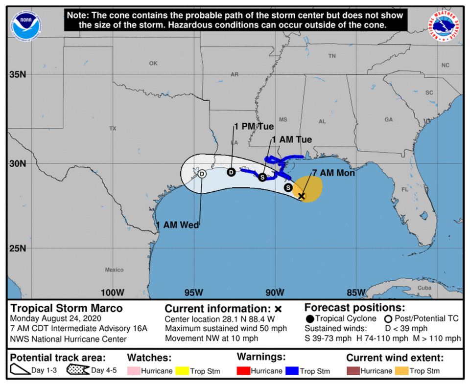
Marco continued to weaken overnight and into Monday morning as it inched closed to Louisiana. Forecasters don’t predict it will re-strengthen to a hurricane before landfall — if it even comes ashore.
Over the weekend, predictions shifted from calling for a direct landfall of a category 1 hurricane to a sideswipe from a tropical storm that could scrape the western half of coastal Louisiana.
“While this seems unlikely given the current structure of the cyclone, it also seems slightly premature to rule it out entirely.”
At 8 a.m. Monday, Marco was down to 50 mph sustained winds. The storm was about 85 miles southeast of the mouth of the Mississippi River. The storm was headed north-northwest at 10 mph. Tropical-storm-force winds extended up to 105 miles from the center.
“Further weakening is expected, and Marco is forecast to become a tropical depression late on Tuesday and dissipate on Wednesday,” forecasters wrote.
Forecasters noted that Marco was a small storm, and the slew of warnings and watches associated with it reflected the uncertainty of the forecast more than the size of the storm. They said more watches and warnings will likely be discontinued Monday.
Wherever it lands, the storm is expected to bring dangerous and life-threatening storm surge as high as six feet from Morgan City, Louisiana to Ocean Springs, Mississippi including Lake Borgne.
Watches/Warning for tropical storms Laura, Marco
▪ Tropical storm warnings remain in effect for Little Cayman and Cayman Brac as well as the Cuban provinces of Camaguey, Las Tunas, Holguin, Guantanamo, Santiago de Cuba, Granma, Ciego De Avila, Sancti Spiritus, Villa Clara, Cienfuegos, Matanzas, Mayabeque, La Habana, Artemisa, Pinar del Rio, and the Isle of Youth. The Dry Tortugas were placed under a tropical storm warning Sunday night.
▪ A tropical storm watch is in effect for the Florida Keys from Craig Key to Key West and the Dry Tortugas
▪ Hurricane warning remains in effect for Morgan City, Louisiana to the mouth of the Pearl River.
▪ A Tropical Storm Warning has been issued from Cameron to west of Morgan City, Louisiana.
▪ Storm Surge warnings in effect for Morgan City Louisiana to Ocean Springs Mississippi, including Lake Borgne.
▪ Storm Surge Watch in effect from the Sabine Pass to Morgan City, Louisiana; Ocean Springs Mississippi to the Mississippi/Alabama border and Lake Pontchartrain and Lake Maurepas.
▪ Hurricane Watch in effect for Lake Pontchartrain, Lake Maurepas and metropolitan New Orleans.
▪ A tropical storm warning is in effect from the mouth of the Pearl River to the Mississippi/Alabama border. Warning also in effect for Lake Pontchartrain, Lake Maurepas, metropolitan New Orleans and Cameron to west of Morgan City.
▪ Tropical Storm Watch in effect from the Mississippi/Alabama border to the Alabama/Florida border.
Miami Herald staff writers David Goodhue and Gwen Filosa contributed to this report.

