Florida Keys under tropical storm watch. Laura’s track moves south, Marco sees ‘big changes’
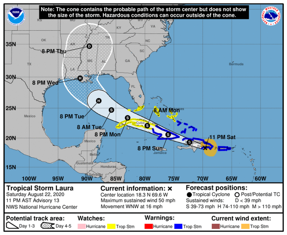
The Florida Keys could feel stormy conditions from a strengthening Tropical Storm Laura on Monday, but mainland Florida appears to be clear of the storm’s track, forecasters said Saturday, as the “disorganized” Laura is forecast to track away from the state after it passes by Puerto Rico, Hispaniola and Cuba.
Tropical Storm Marco is moving through the Gulf of Mexico and Laura is nearing eastern Dominican Republic, according to the National Hurricane Center’s 11 p.m. advisory.
A tropical storm watch was put into effect for the Florida Keys from Ocean Reef to Key West and for the Dry Tortugas, including Florida Bay.
Monroe County has declared a State of Local Emergency and ordered the evacuations of all live-aboard vessels, mobile homes, recreational vehicles, travel trailers and campers in anticipation of the storm.
Tropical Storm Laura is bringing heavy rainfall to Puerto Rico on Saturday, and forecasters expect it to menace Hispaniola on Saturday and parts of Cuba on Sunday on its path away from Florida. Puerto Rico and the Virgin Islands could see between three and eight inches of rain from Laura. The Dominican Republic and Haiti could see four to eight inches of rain, with a foot possible across southern areas, according to the hurricane center.
But while the Florida mainland is out of the cone, the Keys could feel storm conditions on Monday.
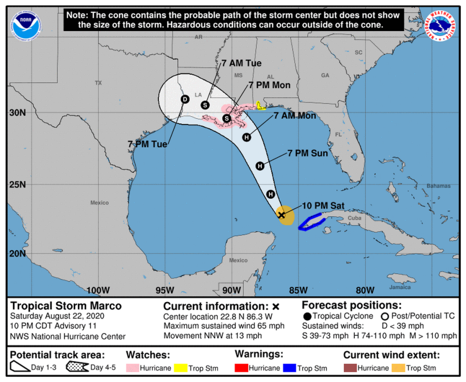
Meanwhile, Tropical Storm Marco, a second storm forecasters are watching in the Caribbean, saw “big changes” in its forecast track and could continue to see “volatile shifts,” according to the 5 p.m. update from the National Hurricane Center.
Both storms, if they survive their journey through the Caribbean, could threaten the U.S. Gulf Coast next week. Marco could be heading for Texas while Laura could menace Louisiana, Alabama and Mississippi.
On Saturday, the Dominican Republic issued a tropical storm watch for Andros Island.
Cuba issued additional tropical storm warnings for the provinces of Ciego De Avila, Sancti Spiritus, Villa Clara,Cienfuegos, Matanzas, Mayabeque, La Habana, Artemisa, and Pinar DelRio, Camaguey, Las Tunas, Holguin, Guantanamo, Santiago de Cuba and Granma.
On Friday, Gov. Ron DeSantis sent a letter to President Donald Trump requesting that he declare a pre-landfall emergency for the state in anticipation of Tropical Storm Laura. He named 34 counties, including Miami-Dade, Monroe, Broward and Palm Beach.

Tropical Storm Laura
Tropical Storm Laura formed in the Atlantic on Friday morning, and as of 11 p.m. Saturday, forecasters say it shouldn’t be seeing additional intensification until Monday night as the storm moves over land over the next 48 hours.
Laura is expected to move across Hispaniola tonight and early Sunday, near or over Cuba on Sunday and Monday and over the southeastern Gulf of Mexico on Monday night and Tuesday.
Laura was about 25 miles southeast of Santo Domingo, Dominican Republic, according to the 11 p.m. Saturday advisory from the hurricane center. It has 50-mph maximum sustained winds with higher gusts and has slightly slowed down from 18 mph to 16 mph.
The forecast track for Laura shows mainland Florida outside its path and only a portion of the Florida Keys in the cone. But the the National Weather Service in Miami tweeted Saturday afternoon that “some impact is STILL POSSIBLE over mainland South Florida, especially if Laura tracks north of the current forecast.”
“No significant changes in strength are forecast during the next 36 to 48 hours while Laura moves near or over Hispaniola and Cuba. Strengthening is forecast once Laura moves into the Gulf of Mexico Monday night and Tuesday,” forecasters said.
Forecasters also don’t see Marco as aiding Laura in her path, “At this time it does not seem likely that Marco, which is forecast to make landfall on the north-central Gulf coast a day or two earlier than Laura, should have much of an influence on the latter system.”
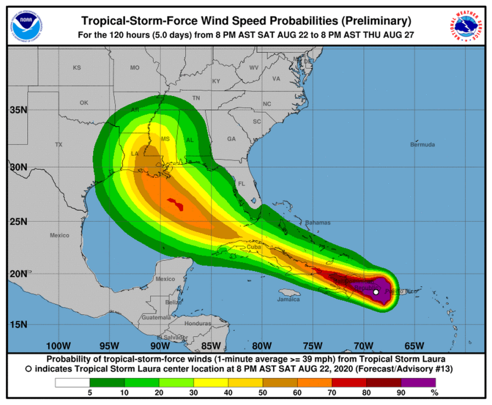
South Florida may feel the effects of Laura as tropical storm-force winds extend 140 miles from the center, mainly to the north, according to the National Hurricane Center. There is a about a 5-10% probability that mainland Miami-Dade County experiences tropical-storm force winds, defined as sustained winds of up to 73 mph. The chances are closer to 30 or 40% in parts of the Florida Keys.
Evacuation ordered for boats, mobile homes as tropical storm tracks toward the Keys
Miami city officials advised residents to be prepare for any potential storm impacts over the weekend. While the latest forecast does not show Miami in Laura’s path, the situation can easily change, said Mayor Francis Suarez.
“All preparation measures need to be wrapped up and buttoned up by Sunday evening,” said Suarez during an afternoon press conference.
The mayor said city crews have inspected storm water pump stations, and all are operating, and the city has contracts prepared to distribute ice and water if it becomes necessary.

Tropical Storm Marco
Tropical Storm #Marco Advisory 8A: Hurricane Hunter Aircraft Finds Marco Continuing to Strengthen. https://t.co/VqHn0u1vgc
— National Hurricane Center (@NHC_Atlantic) August 22, 2020
At 11 p.m. Saturday, Marco had 65-mph maximum sustained winds with higher gusts and is about 110 miles northwest from the western tip of Cuba and about 470 miles south-northeast of the mouth of the Mississippi River. The storm is headed north-northwest at 13 mph.
Marco is forecast to continue moving north-northwestward across the central Gulf of Mexico on Sunday and will approach the northern Gulf Coast on Monday.
A gradual turn toward the west with some slowing down is expected after Marco moves inland on Monday and on Tuesday.
“Some strengthening is anticipated and Marco is forecast to become a hurricane on Sunday. Marco is expected to be at or near hurricane strength when it approaches the northern Gulf Coast on Monday,” forecasters said.
Tropical-storm-force winds extend outward up to 70 miles from the center.

Watches/Warning for tropical storms Laura, Marco
Tropical Storms Laura and Marco have caused a slew of hurricane and tropical storm watches and warnings.
The tropical storm warning has been discontinued for the U.S.Virgin Islands.
The Cuban government issued a tropical storm warning on Saturday for the provinces of Ciego De Avila, Sancti Spiritus, Villa Clara,Cienfuegos, Matanzas, Mayabeque, La Habana, Artemisa, Pinar DelRio, Camaguey, Las Tunas, Holguin, Guantanamo, Santiago de Cuba and Granma.
The Mexican government discontinued its hurricane watch and tropical storm warnings for the northeastern and eastern Yucatan coast.
Marco is forecast to produce one to three inches of rain in eastern portions of Quintana Roo and the Yucatan. It may also bring two to four inches of rain to western Cuba with isolated maximum amounts of six inches and one to three inches to the central U.S. Gulf Coast, which may cause flash flooding.
A storm surge watch has been issued from Sabine Pass eastward to the Alabama and Florida border, including Lake Pontchartrain, Lake Maurepas, Lake Borgne and Mobile Bay.
A hurricane watch has been issued from Intracoastal City, Louisiana, eastward to the Mississippi and Alabama border, including Lake Pontchartrain, Lake Maurepas and Metropolitan New Orleans.
A tropical storm watch has been issued from the Mississippi and Alabama border eastward to the Alabama and Florida border.
Laura caused many warnings to be activated in the Caribbean.
A tropical storm warning is in effect for Puerto Rico, Vieques, Culebra, the U.S. Virgin Islands, the northern coast of the Dominican Republic from Cabo Engano to the border with Haiti, the northern coast of Haiti from Le Mole St. Nicholas to the border with the Dominican Republic, and the southeastern Bahamas and the Turks and Caicos Islands.
A tropical storm watch is in effect for the central Bahamas, Andros Island, Florida Keys from Ocean Reef to Key West and the Dry Tortugas and the Florida Bay
The government of the Netherlands has discontinued the Tropical Storm Warning for Saba and St. Eustatius.
Laura is expected to produce three to six inches of rain over Puerto Rico and the Virgin Islands, with maximum amounts of 8 inches possible along eastern portions and the southern slopes.
The Dominican Republic and Haiti are forecast to see four to eight inches with maximum amounts of 12 inches across southern areas.
Cuba is forecast to have three to six inches with isolated amounts of eight inches.
Forecasters say this heavy rainfall could lead to life-threatening flash and urban flooding, and the potential for mudslides across the Greater Antilles. Widespread minor to potential moderate river flooding is possible in Puerto Rico.
The Leeward Islands, the Turks and Caicos and the southeast Bahamas are projected to see one to three inches of rain with isolated maximum totals of five inches.
What about the other wave in the Atlantic?
The third wave dissipated Saturday evening and is no longer being tracked by the National Hurricane Center, according to the NHC’s 8 p.m. advisory.
In the hurricane center’s 2 p.m. Saturday advisory, they gave it a near zero percent chance of organizing into a tropical cyclone in the next five days.
The next storm name on the list is Nana.

