A tropical storm in mid-November? North Carolina residents are told to get prepared
Even as folks drive past lingering Halloween decorations and prepare for the upcoming Thanksgiving Day feast, Mother Nature has a friendly reminder: We're still in hurricane season despite leaves falling off the trees and most of North Carolina having experienced its first freeze.
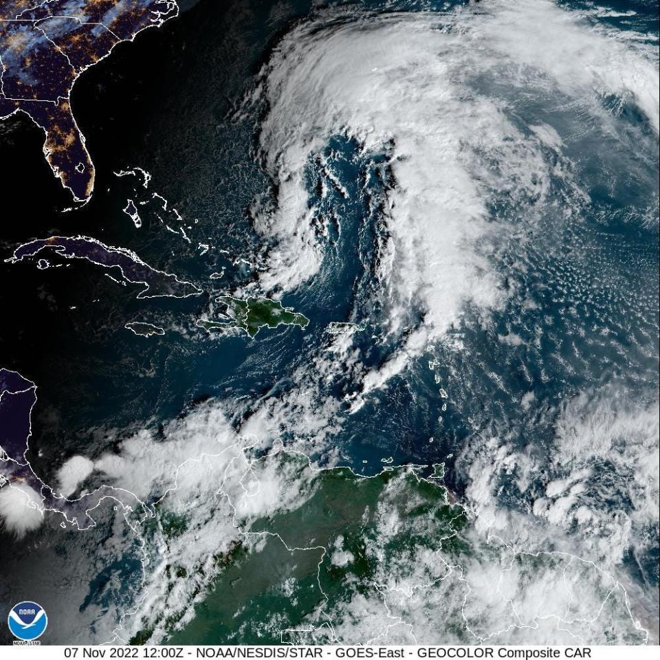
Officials are warning residents of Eastern North Carolina, especially those who live at the coast, to prepare for heavy rains and winds later this week after the National Hurricane Center early Monday upgraded a weather system east of the Bahamas to Subtropical Storm Nicole. The system is expected to strengthen to a tropical storm, with sustained winds over 39 mph, before strengthening even more into a hurricane and striking the northern Bahamas.
According to the current models, Nicole will then rip across the midsection of Florida as a strong tropical storm or weak hurricane on Thursday before reemerging into the Gulf of Mexico.
That's when things could get interesting for residents of the Southeastern U.S., including North Carolina, heading into the weekend. The current forecast is calling for Nicole to loop back around and hit the Florida panhandle before heading toward coastal Georgia and the Carolinas.
Subtropical Storm Nicole:What we can expect along the NC coast
Super storms?:In a warming world, 'Cat 6' hurricanes could soon be coming to a coast near you
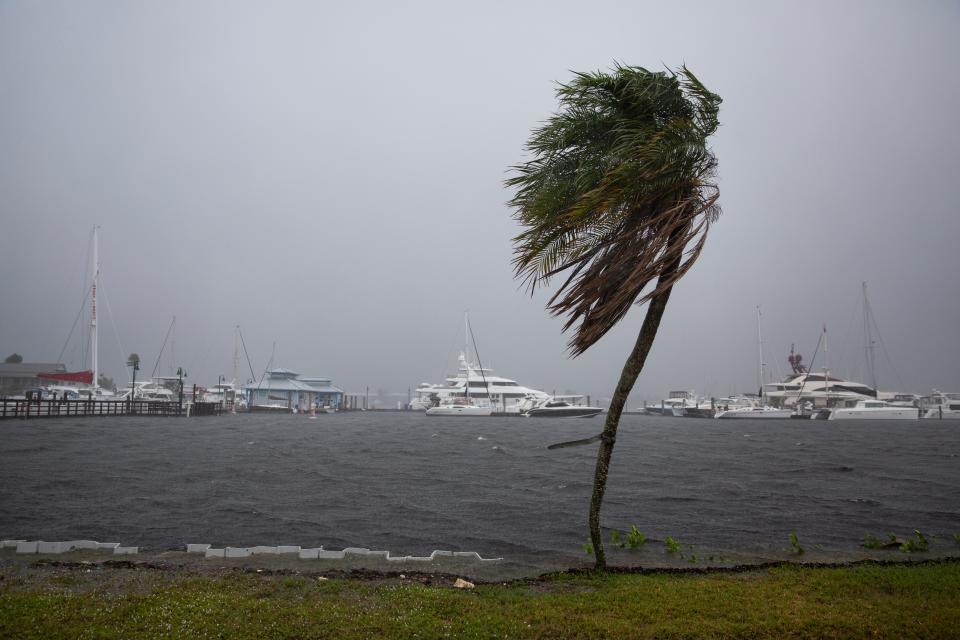
But the storm already has a large footprint, and the National Hurricane Center is forecasting "widespread impacts from a prolonged period of coastal flooding, tropical-storm-force winds, heavy rainfall, rough surf, rip currents and beach erosion" for much of the Southeastern U.S. coast.
Corey Davis, the state's assistant climatologist, said Nicole promises to be a big storm with big impacts, no matter where it goes.
"This is definitely the sort of storm where we shouldn't focus much on the exact track, because it will have impacts far from the center," he said, noting the flooding 2020's Tropical Storm Eta brought to the Tar Heel State even though it made landfall in Florida.
'Imply increasingly active seasons'
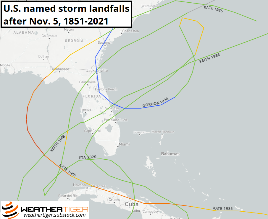
So is a tropical system hitting the U.S. mainland in November unusual?
Davis said while not common, it isn't rare, either.
"Since 1967, which corresponds to the beginning of the modern satellite era in which we've had more comprehensive monitoring of tropical systems, 34 tropical storms have formed in the Atlantic during the month of November," he said via email. "So it's not something we see every year, but it's also not particularly uncommon either. By comparison, there have been 44 tropical storms to form in June over that same 56-year period, so November storms are only slightly less common."
One reason we see fall storms is because the ocean, like a battery charged by the summer sun for months, retains heat for long periods.
"Even though we've already had our first freeze of the season across most of North Carolina, the sea surface temperatures in the heart of the Gulf Stream not far off our coast are still around 80 degrees Fahrenheit, which is still warm enough to support tropical development," Davis said.
As ocean heat content continues to increase due to climate change, that could provide the petri dish for more frequent or even more intense storms later in hurricane season, which runs June 1 through November.
Dr. Michael Mann, director of the Earth System Science Center at Penn State University, said La Nina conditions, which are expected to continue through Christmas, generally mean more storm activity tending to extend into late fall.
"The same statistical model we’ve used so successfully to predict seasonal storm totals shows that both warming and La Nina conditions lead to more active seasons," he said via email. "We have published other work suggesting that the future will not only be warmer but also more La Nina-like in character, which would imply increasingly active seasons."
If La Nina does continue through winter 2022 as predicted, it would represent this century's first "triple dip" event spanning three consecutive northern hemisphere winters, according to the World Meteorological Organization. La Nina usually brings warmer temperatures and drier than normal conditions to the Southeastern U.S.
With most climatologists predicting a warmer future to mean more frequent and potentially stronger tropical systems in coming years, should the start and end dates of hurricane season be tweaked?
Between 2015 and 2021, a named storm formed in the Atlantic every year prior to the "official" June 1 start of hurricane season.
But the bulk of storm activity still occurs in August and September. Davis said atmospheric conditions are also generally less conducive for storm formation in the fall, including the southern dip of the jet stream in the northern hemisphere as the weather cools.
Sand castles?:North Topsail is getting millions for beach nourishment. How long will the sand last?
Water woes:Could it take a hurricane to pull Eastern NC out of its stubborn drought?
Mann, however, said climate change has the potential to upend many atmospheric norms, and we're already seeing storms form outside the usual window.
"I’ve always felt that both the beginning and ending boundaries are artificial since they’re not really tied to anything physical about the climate system," he said. "It is possible, as we’ve seen in many instances, to have storms in nearly every month of the year, so it’s time to adopt a definition that is more tied to the real world."
Back in drought
If Nicole − as expected − does arrive in North Carolina, at least one of the storm's impacts will likely be welcomed.
Most of the state is in drought or abnormally dry after an exceedingly dry October, which saw Wilmington record less than 0.6 inches of rain, according to the National Weather Service. For 2022, the Port City is 16.5 inches below normal precipitation levels.
The dry spell, which follows a nine-month-long drought across much of Eastern North Carolina which only ended in early summer, has prompted the U.S. Drought Monitor to declare nearly 84 percent of North Carolina as abnormally dry or in moderate drought − with a pocket near the Tennessee border classified as in severe drought.
In the state's coastal plain, all of New Hanover County and most of Brunswick, Pender, Duplin and Onslow counties are in moderate drought.
Reporter Gareth McGrath can be reached at GMcGrath@Gannett.com or @GarethMcGrathSN on Twitter. This story was produced with financial support from 1Earth Fund and the Prentice Foundation. The USA TODAY Network maintains full editorial control of the work.
This article originally appeared on Wilmington StarNews: North Carolina residents told to prepare as Nicole forms

