Tropical Storm Nicole live updates: Roads flooding during high tide; power outages reported
The Florida Times-Union has made this article free of charge for all readers in the interest of public safety. Please consider supporting local journalism with a digital subscription.
Nicole made landfall on Florida's East Coast as a Category 1 hurricane at about 3 a.m. Thursday, just south of Vero Beach.
Locally, school districts in Duval, St. Johns and Clay counties are closed today.
Also in Jacksonville, a state of emergency went into effect at midnight and two emergency shelters are expected to open at 8 a.m. for residents, including those with special needs, seeking shelter. They include:
The Legends Center, 5130 Soutel Dr.: Open for general population, special needs, and pet-friendly.
Landmark Middle, 101 Kernan Blvd.: Open for general population and pet-friendly.
No evacuations have been ordered.
Jacksonville offices will be closed Thursday and Friday.
Curbside garbage, recycling, bulk and yard waste collections are canceled for Thursday. The make-up day will be Saturday, Nov. 12.
Major events were also disrupted: The Jacksonville Fair is closed today and has reduced hours on Friday. The city's Veterans Day parade on Friday was canceled.
Follow our live blog throughout the day for more updates.
Quick Northeast Florida Tropical Storm Nicole links:
Tropical Storm Nicole: See the latest forecast, tracking map
What's open? What we know about closings and cancellations in the Jacksonville area
Big events disrupted: Tropical Storm Nicole forces Jacksonville Fair, Cummer to alter hours
When do bridges shut down? Here's what we know.
What to expect: How Nicole is expected to affect Jacksonville area
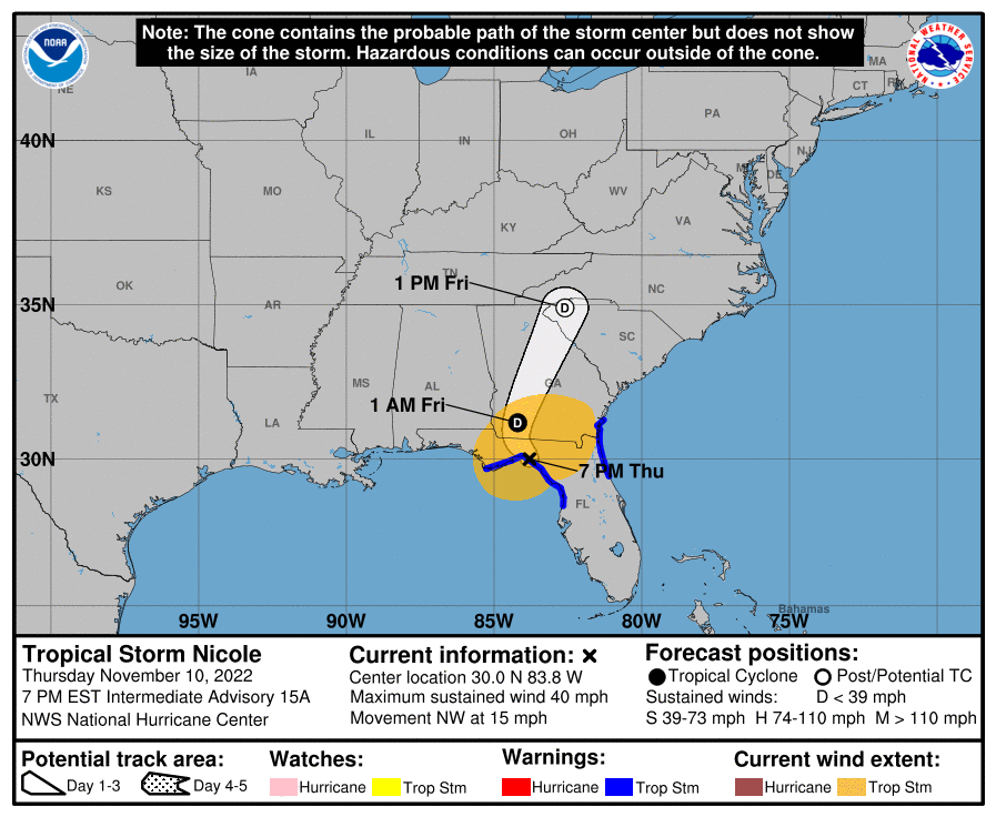
7 p.m. | New National Hurricane Center advisory: Nicole winds now 40 mph
The National Hurricane Center issued its new advisory on Tropical Storm Nicole, which is now centered about 40 miles southeast of Tallahassee. The storm's intensity continues to diminish over land, but the threat of flooding persists.
The key numbers in the 7 p.m. advisory:
Location: 30.0°N 83.8°W
Motion: NW at 15 mph
Minimum central pressure: 990 mb
Maximum sustained winds: 40 mph
6:20 p.m. | Jacksonville Sheriff's Office urges residents to avoid flood areas
The Jacksonville Sheriff's Office again called on residents to stay off the roadways as Tropical Storm Nicole begins moving away from North Florida. Water levels are expected to rise again later tonight as high tide approaches.
In a social media post, JSO said that it "is seeing large numbers of vehicles/people in areas experiencing high levels of flooding. This is distracting from resources and delaying assistance from all agencies working to keep citizens safe and roadways clear. PLEASE stay home and off the roadways unless necessary."
In St. Augustine earlier Wednesday, a man sustained injuries that were apparently the result of exposure to live electricit
6:05 p.m. | St. Augustine reopens Bridge of Lions
St. Augustine emergency management officials announced that the Bridge of Lions is now back open, in addition to King Street in downtown St. Augustine.
5 p.m. | JaxPort plans Friday morning reopening
As originally planned, JaxPort expects to reopen its gates at 6:30 a.m. Friday. Operating hours for companies conducting business within the port may vary.
In addition, Carnival announced in an afternoon update that the Carnival Elation cruise ship is expected to return to Jacksonville on Friday after port officials complete a standard assessment. The voyage that was originally scheduled to begin today will instead take place Friday, as a three-day trip with a single stop in the Bahamas.
4:25 p.m. | All roads open in Neptune Beach
Neptune Beach officials announced that all roads have been reopened following coastal flooding. However, some roads could be forced to close again this evening around the time of high tide, which is about 9:30 p.m.
4:10 p.m. | Bystanders rescue man they say was shocked by live wire in St. Augustine floodwaters
A man was apparently shocked by a live wire in St. Augustine floodwaters on Thursday as the area experienced the effects of Tropical Storm Nicole, before being rescued by bystanders. | Read more --Corey Perrine
3:55 p.m. | Six weeks after Ian, St. Augustine neighborhood underwater again from Hurricane Nicole
Georgina Perez and her husband, Garrett, are watching via a camera mounted on a palm tree as their home in Davis Shores floods for a second time in as many months.
Their home, which sits at the corner of Arricola and Zorayda avenues in the St. Augustine neighborhood, had a foot of water in it by 9 a.m. on Thursday after Nicole made landfall on Florida's east coast as a Category 1 hurricane. | Read more --Katherine Lewin
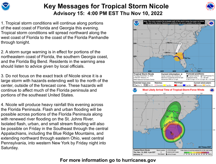
3:45 p.m. | New National Hurricane Center advisory: Key numbers on Nicole
As of the 4 p.m. advisory, Nicole is still spinning at tropical storm strength, with a center of circulation about 15 miles northwest of Cedar Key in Florida's Big Bend. Tropical storm warnings remain in effect for Northeast Florida, although they have been discontinued from Volusia County southward.
Position: 29.4°N 83.2°W
Movement: NW at 15 mph
Minimum central pressure: 990 mb
Maximum sustained winds: 45 mph
The National Hurricane Center expects Nicole to weaken to a tropical depression tonight over Georgia, eventually accelerating to the northeast toward the Carolinas.
3:35 p.m. | St. Johns County officials warn of 'significant impact' from Nicole
St. Johns County emergency officials said during a mid-afternoon press conference flood waters are receding for now in the county, but conditions are expected to worsen again as high tide approaches around 9:30 p.m.
St. Johns County Fire Rescue chief Jeff Prevatt said the department has performed multiple rescues, particularly along the stretch of A1A that collapsed following erosion. About 6-7 miles of A1A are described as compromised, and some other roads in and around St. Augustine are flooded or impassable. Currently, crews are removing loose chunks of asphalt and strengthening the road ahead of the next high tide.
Several other notes from the press conference:
A circuit was taken down after an individual received an electric shock in floodwaters in St. Augustine, and no timetable was announced for its return. Officials did not provide further details about the person's condition.
Tropical storm-force gusts are still expected through Friday. However, because Nicole is now northwest of the area, winds for tonight's high tide will be coming from the opposite direction, which is less likely to drive tidal waters onshore.
St. Augustine city manager John Regan said the storm has produced flooding within about two inches of that produced by Hurricane Ian in September.
The Bridge of Lions remains closed until its assessment by the Department of Transportation.
3 p.m. | Nearly 7,000 JEA customers without power
As of 3 p.m., JEA reported 6,943 customers without power, well below the peak from earlier today. Most of the outages are located east of the St. Johns River.
Meanwhile, the Florida Department of Transportation has begun repairs to A1A in St. Johns County.
FDOT District Two Secretary Greg Evans and crews are currently in Vilano Beach working to repair sections of A1A damage by Tropical Storm Nicole. pic.twitter.com/5sFxyiNpQq
— FDOT District 2 (@MyFDOT_NEFL) November 10, 2022
2 p.m. | St. Johns County: 6-mile stretch of A1A closed
St. Johns County emergency management officials announced that a 6-mile stretch of A1A — between Guana River Road and Carcaba Road, covering portions of Vilano Beach and South Ponte Vedra Beach — is currently impassable because of flooding.
1:30 p.m. | St. Johns County officials: Please stay home
St. Johns County officials are asking residents to stay home and shelter in place even as it appears that the worst of Nicole has passed.
That's because the county is still experiencing areas of flooding, closing roadways and damaging homes, and even forcing rescues of some residents from their homes, said St. Johns County Administrator Hunter Conrad.
NICOLE UPDATE: Important Public Safety Message from St. Johns County Administrator Hunter Conrad.
#MySJCFL #Nicole pic.twitter.com/9Tz7zVRYBS— St. Johns Co EOC (@StJohnsEOC) November 10, 2022
Also, officials say that a 6-mile stretch of A1A from Guana River Road to Carcaba Road is impassable at this time and for residents in the area to remain at home.
NICOLE UPDATE: If you live between Guana River Road and Carcaba Road, we urge you to stay home until conditions improve. This roughly six mile stretch of A1A is impassable.
If you have a life-threatening emergency call 911, high-water vehicles are able to access this area. pic.twitter.com/aA7y5BYsme— St. Johns Co EOC (@StJohnsEOC) November 10, 2022
12:25 | Mayor Curry: Stay out of the water and off the roads
During a delayed press briefing, Jacksonville Mayor Lenny Curry said that Duval County remains under a state of emergency, tropical storm warning and flood surge warning due to Nicole.
"The biggest threat that remains is storm surge and coastal flooding along the beaches and St. Johns River," Curry said, noting that he does not expect evacuations but that anyone needing shelter can use one of two emergency shelters opened by the city this morning.
More than two dozen residents have sought shelter at Landmark Middle School and Legends Center, a member of Curry's staff said.
Once again, the mayor implored residents to "stay out of the water and off of the beaches" due to the increased risk posed by weather conditions.
Noting several traffic accidents, including one that closed the Dames Point Bridge, Mayor Curry also asked residents to stay off the roads until the storm passes and the tidal flooding events have subsided.
12:15 p.m. | Surf pounds Vilano Beach
Heavy surf from Nicole continues to pound the coastline, and in Vilano Beach, video shared by First Coast News shows heavy damage to the dunes and parts of A1A, areas that were hit hard by Ian.
More Vilano Beach damage. Fun fact: Half the money St. Johns County spent on Irma recovery went to dune rehabilitation and sand placement. @FCN2go pic.twitter.com/2MI7OZ7FqA
— anne schindler (@schindy) November 10, 2022
Vilano Beach destruction -- A1A and dunes eviscerated @FCN2go 📸@gracelking pic.twitter.com/O7GAkCzQWH
— anne schindler (@schindy) November 10, 2022
11 a.m. | Flooding in St. Augustine at high tide
Here's a look at some of the flooding in St. Augustine during high tide on Thursday morning.
10 a.m. |Power outages reported
About 23,000 customers are without power in the JEA service area.
JEA crews have been out this morning working on issues as they come up.
JEA is working to restore services as quickly as possible.
Safety Tip: When you see JEA crews or first responders working on the side of the road, please move over or slow down.#Nicole #CommunityPowered #MoveOverFL pic.twitter.com/ORLFSknAPO— JEA (@NewsfromJEA) November 10, 2022
In addition, about 11,000 people in Clay County are without power right now, and about 4,000 people in St Johns County, according to poweroutage.us.
Is your electricity out? See the latest power outages in Duval, Clay, St. Johns and Nassau counties
9:50 a.m. | High tide brings more flooding to Northeast Florida
Now that it's high tide in our area, the St Augustine Police Department is reporting that the city is flooding at a rapid pace, with several roads impassable. They're asking people to avoid driving if possible.
Also, here's what it was looking like in Jacksonville Beach during high tide:
We have reached high tide in Jax Beach during Nicole. Sorry about the camera movement, but I had to save my hat and myself from being knocked over. The wind is the strongest I’ve felt all day. pic.twitter.com/lGxEOPSVQH
— Leah Shields (@LeahShieldsNews) November 10, 2022
9:30 a.m. | Flooding continues in St Augustine
More areas than usual are flooding in St Augustine.
Downtown St. Augustine 3 hours ago and now. High tide still a half hour out. pic.twitter.com/9dg2k0aOKH
— anne schindler (@schindy) November 10, 2022
The city is flooding at a rapid pace and the “Bridge of Lions” is closed. Please avoid driving if possible. There are several roads that are impassable and closed, more than the usual flooded areas. @wjxt4 @FCN2go @ActionNewsJax #staugstrong pic.twitter.com/XzKhO0iZhF
— St. Augustine Police Department (@STAUGPD) November 10, 2022
Davis Shores, which experienced flooding during Hurricane Ian, is again seeing rising water.
Water is starting to wash ashore as the river continues to rise in Davis Shores. I’d say it’s risen about a foot in the last hour #Nicole @FCN2go pic.twitter.com/1gn76m5hmA
— Rich Donnelly (@RichFCN) November 10, 2022
8:00 a.m. | Many flights at Jacksonville International Airport canceled today
Jacksonville International Airport is open, but many flights have been canceled.
You can see flight updates here. Also, the airport says check your flight status directly with your carrier.
JAX remains OPEN today (11/10) however many arrivals and departures have been cancelled. Check directly with your airline for the most up-to-date information on flight status. #TropicalStormNicole pic.twitter.com/d7MUz6PBaO
— JAXairport (@JAXairport) November 10, 2022
Also, more roads are closed in St Johns County because of flooding.
St Augustine: Due to flooding the following roadways are closed: SR-A1A / Bridge of lions, King St between Sebastian Harbor Dr and Ponce de Leon Blvd, SR-A1A at Carcaba Rd, A1A/ May St and Douglas Ave. Avoid the area. https://t.co/q6rZmrHo4a
— FL511 Northeast (@fl511_northeast) November 10, 2022
7:55 a.m. | Flooding blocks part of SR A1A in St Augustine area
Flooding blocks State Road A1A at Carcaba Road in St Augustine area, the Florida Department of Transportation reports.
St Augustine: Due to Flooding all lanes are blocked on SR A1A at Carcaba Rd. Use Caution in the area and seek an alternate route. https://t.co/q6rZmrHo4a
— FL511 Northeast (@fl511_northeast) November 10, 2022
7:30 a.m. | Bridge of Lions closed to traffic
The Bridge of Lions is blocked to traffic this morning, the Florida Department of Transportation reported. All lanes are closed.
The closure comes after First Coast News' Lew Turner reported that at least two sailboats had broken loose and hit the bridge.
Tropical Storm Nicole: When can Jacksonville-area bridges be expected to be shut down?
Another sailboat breaks loose and hits the bridge of lions. Emergency vehicles/personnel are over there dealing with that. The other boats are still holding strong. #FCNstorm #gmj pic.twitter.com/twvm6nDpMK
— Lew Turner (@LewTurner) November 10, 2022
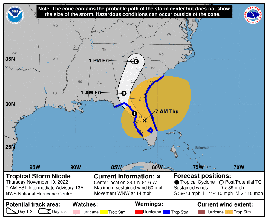
7:00 a.m. | Latest report from the National Hurricane Center
Nicole continues to move into Central Florida WNW at 14 mph, with maximum sustained winds of 60 mph
6:30 a.m. | Sights and sounds early this morning
First Coast News, our news partner, has crews in parts of Northeast Florida and Southeast Georgia this morning. Here are a few of the things they're seeing and hearing:
The popping noise you hear (sounds like gun shots) is coming from the USS Orleck. Choppy waves are rocking the boat back. @FCN2go pic.twitter.com/nNLtWyHbXg
— Atyia Collins (@Atyia_Collins) November 10, 2022
6 a.m. Update: I’m now in Neptune Beach. Really strong gusts of wind here. The traffic light at Atlantic Blvd & First St is out. pic.twitter.com/mZMFCqyGpo
— Leah Shields (@LeahShieldsNews) November 10, 2022
Current conditions in Davis Shores, lots of wind, rain also starting to pick up #Nicole @FCN2go pic.twitter.com/abxoBU9BcS
— Rich Donnelly (@RichFCN) November 10, 2022
Take a look at the “what’s supposed to be” beach area in front of the St. Simons Lighthouse. Since at least 3am the beach has been completely cover by water. High tide is around 9:30am @FCN2go #GMJ @JGrantSports pic.twitter.com/bb9vqgkZqb
— Mekena Rodriguez (@MekenaRodriguez) November 10, 2022
6:20 a.m. | Tornado watch issued for Northeast Florida
A tornado watch is in effect until 1 p.m. today throughout much of Northeast Florida.
A tornado watch has been issued for parts of Florida and Georgia until 1 PM EST pic.twitter.com/hEFAgP6ULw
— NWS Jacksonville (@NWSJacksonville) November 10, 2022
6:00 a.m. | Major beach erosion concerns locally
Nicole is bringing moderate to major tidal flooding around high tide today, the National Weather Service is reporting.
Concerns include destructive surf, major beach erosion and deadly rip currents at all local beaches, according to the service.
There are also threats of tornados, with areas east of I-95 most vulnerable.
Localized flash flooding is possible. Winds could cause fallen trees or limbs, power outages and damage to buildings or mobile homes. The debris could block some roads.
5:45 a.m. | Nicole made landfall just south of Vero Beach
The National Weather Service reported that Nicole made landfall at about 3 a.m. on North Hutchinson Island just south of Vero Beach. Maximum sustained winds were at about 75 mph. Winds were down to 70 mph by the 4 a.m. update.
Along Jacksonville's coast, wind gusts were reported at between 40 to 55 mph shortly after Nicole made landfall.
Peak storm surge is expected along the coast of Northeast Florida between 9 a.m. and 10 a.m., with impacts on the St Johns River throughout the afternoon.
🌀 Peak Wind Gusts as of 3:30 am 11/10 across SE GA & NE FL
🌬️ Local coastal counties are gusting 40-55 mph
⚠️ Stay sheltered as frequent strong gusts will weaken trees and cause some structure damage#jaxwx #gawx #flwx pic.twitter.com/E1zSt9bvM3— NWS Jacksonville (@NWSJacksonville) November 10, 2022
5 a.m. | Updated tracking map, forecast for Tropical Storm Nicole
Here's the latest update on Tropical Storm Nicole from the National Hurricane Center.
This article originally appeared on Florida Times-Union: Hurricane Nicole in Jacksonville, Thursday: What you need to know

