Tropical Depression forms in the Eastern Atlantic. What does the forecast say?
- Oops!Something went wrong.Please try again later.
A new disturbance rolled off Africa’s coast in the far Eastern Atlantic Saturday afternoon, within hours of Tropical Depression 17 forming in the Eastern Atlantic between the 11 a.m. and 2 p.m. National Hurricane Center advisories.
Meantime, after making landfall near Emerald Isle, North Carolina, Saturday morning with 70-mph winds and flooding rains, Tropical Storm Ophelia continues to move inland over far eastern North Carolina with heavy rain and tropical storm conditions along portions of the East Coast.
Here are the latest updates on the three systems from the hurricane center:
Tropical depression formed in Eastern Atlantic
Tropical Depression 17 formed Saturday morning, according to the hurricane center’s 11 a.m. advisory.
Strength: Maximum sustained winds are near 35 mph with higher gusts.
Movement: The depression was 985 miles west of the Cabo Verde Islands and was moving west near 15 mph. This general motion, with a slight decrease in forward speed, is expected over the weekend and Monday, hurricane specialist David Zelinsky said in Saturday’s advisory.
Forecast: TD 17 is expected to grow stronger through early next week.

A new wave off Africa’s coast
A new tropical wave emerged off the west coast of Africa Saturday afternoon and is producing a broad area of disorganized showers and thunderstorms. Environmental conditions are conducive for some gradual development of this system during the middle to latter portions of next week while it moves west across the eastern and central tropical Atlantic, the hurricane center said in the 2 p.m. advisory.
▪ Formation chance through 48 hours: 0%.
▪ Formation chance through seven days: 20%.
Tropical Storm Ophelia
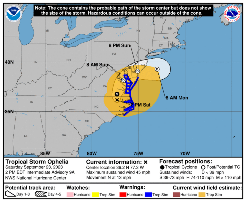
Movement: The system was about 95 miles south of Richmond, Virginia, and about 80 miles north-northeast of Raleigh, North Carolina, in the hurricane center’s 2 p.m. Saturday advisory.
Forecast track: Ophelia is expected to continue moving north Saturday, followed by a northeast turn Sunday. The center of Ophelia will move across eastern North Carolina Saturday morning, and then move into southeastern Virginia and the Delmarva Peninsula by the end of Saturday and into Sunday, according to hurricane specialist Philippe Papin’s Saturday advisory.
Strength: Maximum sustained winds decreased to 45 mph with higher gusts as the system was moving north across land at 13 mph. Tropical-storm-force winds extend outward up to 320 miles from the center.
Watches and warnings:
▪ A tropical Storm Warning is in effect for east of Cape Lookout to Fenwick Island; Albemarle and Pamlico Sounds; Tidal Potomac south of Cobb Island and Chesapeake Bay south of North Beach.
▪ A storm surge warning is in effect for Ocracoke Inlet, North Carolina, to Chincoteague, Virginia; Chesapeake Bay south of Colonial Beach, Virginia; Pamlico River; and portions of Pamlico and Albemarle Sounds.
▪ Forecast: Further weakening is expected through the rest of the weekend and Ophelia is likely to become a post-tropical cyclone Saturday night or Sunday morning, according to the hurricane center.
A tornado or two remains possible over parts of the mid-Atlantic coast.
READ MORE: What is causing a solid week of thunderstorms in the Miami area?
South Florida marine forecast
Tropical Storm Ophelia will affect weather in South Florida off Palm Beach County’s coast over the weekend due to elevated seas and a northerly swell generated by Tropical Storm Ophelia, the National Weather Service said on Saturday morning. A small craft advisory is in effect until 8 p.m. Saturday.
The next advisory is at 5 p.m.

