Tropical Storm Sean has formed in the Atlantic. And behind that, another tropical wave
The tropical wave moving across the eastern Atlantic Ocean has done what was forecast and strengthened into Tropical Storm Sean. Following Sean is another disturbance coming off an African coast.
Here’s the latest updates from the National Hurricane Center on each.
Tropical Storm Sean
“Little change in strength is forecast during the next 72 hours,” the hurricane center said in its 5 p.m. Wednesday advisory.
The tracking map says Sean is expected to be back to tropical depression level by Monday morning.
Strength: Sean’s maximum sustained winds at the 5 p.m. advisory held at 40 mph with greater gusts. Tropical storm force winds, which means at least 39 mph, have been measured up to 90 miles from Sean’s center.
Location: About 815 miles west-southwest of the Cabo Verde Islands.
Movement: Sean is moving west-northwest at 13 mph. A west-northwest to northwest motion is forecast during the next few days, the center said Wednesday.
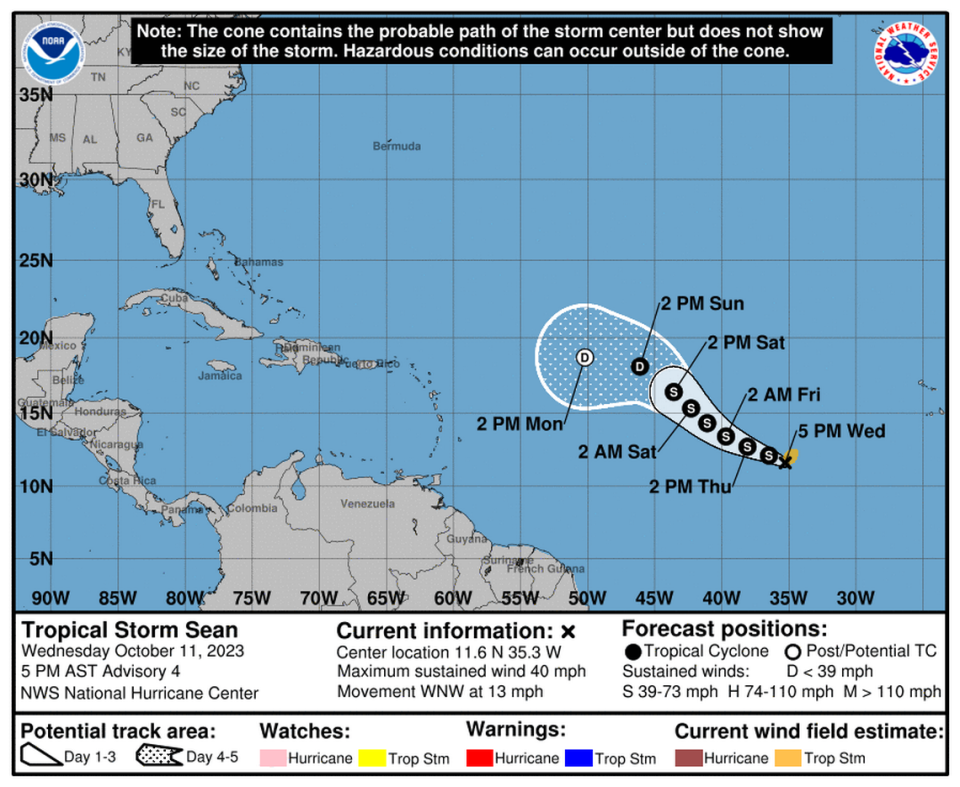
Hazards: None yet.
Current threat to the U.S. East Coast, including Florida: None forecast at this time.
Next advisory: The next full advisory will be at 11 p.m.
What’s this new disturbance coming off Africa?
A tropical wave moved off of Africa’s west coast early Wednesday and was several hundred miles to the south-southeast of the Cabo Verde Islands as of Wednesday’s 8 p.m. advisory. The system was showing signs of organization in the morning. That hasn’t changed.
“Environmental conditions appear conducive for some slow development over the next few days. This system should move generally westward across the eastern and central tropical Atlantic through early next week,” the center said in its night advisory.
Formation chance through 48 hours: 20%.
Formation chance through seven days: 30%.
Miami’s first cold front of the season follows storms and heat. How cold will it get?

