Tropical Storm Tammy expected to become hurricane Saturday. See latest spaghetti models
Tropical Storm Tammy strengthened rapidly this morning and is expected to become a hurricane by Saturday morning, according to the latest advisory from the National Hurricane Center.
Winds increased from 40 mph to 60 mph between 5 a.m. and 8 a.m. Maximum sustained winds remained at 60 mph at the 5 p.m. advisory. The storm is still moving to the west.
Tammy is forecast to be at or near hurricane intensity when it moves near the Leeward Islands.
A hurricane watch has been issued for Guadeloupe, Antigua, Barbuda, Montserrat, St. Kitts, and Nevis. Tropical storm watches and warnings have been issued for several islands in the northeastern Caribbean, where tropical storm conditions and heavy rain are possible beginning Friday.
Over the weekend, an area of high pressure across the northern Atlantic will begin to affect Tammy's path.
After Tammy moves near the Leeward Islands in the northeastern Caribbean over the weekend, it is expected to turn more toward the north and then northeast by early next week, according to AccuWeather.
The Florida Division of Emergency Management said Tropical Storm Tammy poses no direct threat to Florida over the next five to seven days.
Two names remain on the 2023 list of storms: Vince and Whitney. Hurricane season doesn't end until Nov. 30, although storms can and do form any time.
This season has been above the historical average when it comes to named storms. During an average hurricane season, 14 named storms form in the Atlantic basin, which covers the Atlantic Ocean, Caribbean Sea and Gulf of Mexico.
Tammy no threat to US: Tammy is born and storm season odds shift in our favor; but a spooky pattern may emerge
Here's the latest update from the NHC as of 5 p.m.:
Tropical Storm Tammy: How strong are the winds?

Special note on the NHC cone: The forecast track shows the most likely path of the center of the storm. It does not illustrate the full width of the storm or its impacts, and the center of the storm is likely to travel outside the cone up to 33% of the time.
Location: 200 miles east of Barbados; 300 miles east-southeast of Martinique
Maximum sustained winds: 60 mph
Movement: west-northwest at 13 mph
At 5 p.m., the center of Tropical Storm Tammy was located near latitude 13.7 North, longitude 56.6 West. Tammy is moving toward the west-northwest near 13 mph. A slower west-northwestward motion is expected tonight. A turn toward the northwest is forecast on Friday, and this motion should continue through Saturday. A northward motion is forecast to begin Saturday night or Sunday.
On the forecast track, the center of Tammy will move near or over the Leeward Islands Friday and Saturday, and then move north of the Leeward Islands Saturday night and Sunday.
Data from an Air Force Reserve reconnaissance aircraft indicate that the maximum sustained winds are near 60 mph, with higher gusts. Little change in strength is expected tonight, but gradual strengthening is expected to begin Friday and continue into this weekend. Tammy is forecast to be at or near hurricane intensity when it moves near the Leeward Islands Friday night and Saturday.
Tropical-storm-force winds extend outward up to 125 miles, primarily to the east of the center.
The estimated minimum central pressure is 1001 mb.
Spaghetti models for Tropical Storm Tammy
Special note about spaghetti models: Illustrations include an array of forecast tools and models, and not all are created equal. The hurricane center uses only the top four or five highest performing models to help make its forecasts.
Watches and warnings in effect in advance of Tropical Storm Tammy
A hurricane watch is in effect for:
Guadeloupe
Antigua, Barbuda, Montserrat, St. Kitts, and Nevis
A tropical storm warning is in effect for:
Guadeloupe
Antigua, Barbuda, Montserrat, St. Kitts, and Nevis
Dominica
A tropical storm watch is in effect for:
Barbados
Martinique
Anguilla
Barthelemy
Saba and St. Eustatius
St. Maarten
St. Martin
Who is likely to be impacted?
No impacts to Florida or the rest of the U.S. are expected at this time from Tropical Storm Tammy.
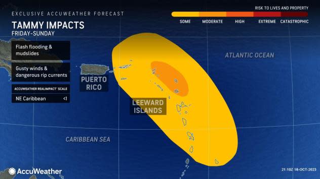
Wind: Tropical storm conditions are expected within the tropical storm warning area beginning Friday. Hurricane conditions are possible in portions of Leeward Islands Friday night and Saturday. Tropical storm conditions are possible within the tropical storm watch area beginning on Friday.
Rainfall: Tammy is expected to produce storm total rainfall of 3 to 6 inches, with maximum amounts of 10 inches, across portions of the northern Windward and Leeward Islands. Rainfall totals of 1 to 2 inches with maximum amounts of 4 inches are expected for the British and U.S. Virgin Islands into eastern Puerto Rico. These rains may produce isolated flash and urban flooding, along with isolated mudslides in areas of higher terrain.
Surf: Swells generated by Tammy will continue to affect portions of the Lesser Antilles during the next few days. These swells are likely to cause life-threatening surf and rip current conditions.
Storm surge: Storm surge could raise water levels by as much as 1 to 3 feet above normal tide levels near where the center of Tammy moves across the Leeward Islands.
Forecasters urge all residents to continue monitoring the tropics and to always be prepared.
Key messages from the Hurricane Center: What you need to know about Tropical Storm Tammy
Tropical storm conditions are expected to begin in portions of the Lesser Antilles on Friday, where a tropical storm warning is in effect. Tropical storm and hurricane conditions are possible elsewhere in the Leeward Islands where hurricane and tropical storm watches are currently in effect. Additional watches and warnings will likely be required later today.
Heavy rains from Tammy will begin to affect the northern Windward and Leeward Islands on Friday, spreading into the British and U.S. Virgin Islands and Puerto Rico over the weekend. This rainfall may produce isolated flash and urban flooding, along with isolated mudslides in areas of higher terrain.
Looking ahead: Maximum winds forecast for Tropical Storm Tammy
12 hours: 60 mph
24 hours: 65 mph
36 hours: 70 mph
48 hours: 75 mph
60 hours: 80 mph
72 hours: 85 mph
96 hours: 85 mph
120 hours: 85 mph
Weather watches and warnings issued in Florida
When is the Atlantic hurricane season?
The Atlantic hurricane season runs from June 1 through Nov. 30.
When is the peak of hurricane season?
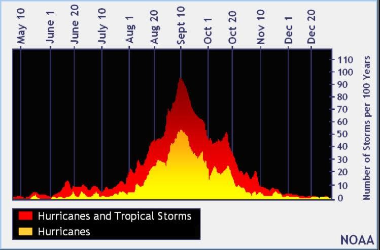
The peak of the season is Sept. 10, with the most activity happening between mid-August and mid-October, according to the Hurricane Center.
Tropical forecast over the next seven days
Excessive rainfall forecast
What's out there?
Systems currently being monitored by the National Hurricane Center.

Noaa
Embedded content: https://www.nhc.noaa.gov/xgtwo/two_atl_0d0.png?052051
What's next?
We will continue to update our tropical weather coverage daily. Download your local site's app to ensure you're always connected to the news. And look at our special subscription offers here.
This article originally appeared on Treasure Coast Newspapers: NHC tracking Tropical Storm Tammy. Spaghetti models, Florida impact

