Waves, winds batter Delaware beaches as communities see coastal flooding Saturday
Editor's note: This story and headlines have been updated to correctly reflect the warning for Delaware. Much of the state is under a coastal flood warning.
Delaware saw a wet and windy Saturday as then-Tropical Storm Ophelia headed its way.
Delaware and other parts of the East Coast were hit with rain and strong gusty winds Saturday, expected to last through the evening and into parts of Sunday. The storm is in effect from northeast North Carolina and includes parts of Maryland, Virginia and Fenwick Island as it continues northward, according to the National Weather Service.
The storm made landfall on the coast of North Carolina near Emerald Isle on Saturday morning and moved inland across the state, according to forecasters with the National Hurricane Center.
At 7:44 p.m., the center said that Ophelia had slowed to become a tropical depression, which is a weak form of a tropical storm, and all storm surge and tropical storm warnings had been discontinued.
Heavy rain began early Saturday morning, with National Weather Service forecasters predicting another round later in the day. Between 2 to 3 inches of rain are expected in the Delaware area. As of 6 p.m. Saturday, Harbeson recorded the highest rainfall total across the state with 3.64 inches, according to the Delaware Environmental Observing System. Close behind were nearby areas of Stockley and Dagsboro.
New Castle County reported far less, with Newark reporting about 1.5 inches of rain as of 6 p.m. Saturday.
The worst impacts of the storm were expected along the Delaware beaches and the Jersey shore Saturday night, especially around high tide and in the hours after. Wind gusts could reach up to 60 mph, according to the weather service, which could make it more difficult for water to recede and flow back out to sea.
Here's a look at what happened throughout Delaware on Saturday.
WHAT TO KNOW: Ophelia causes coastal flood warning for southern Delaware, New Jersey
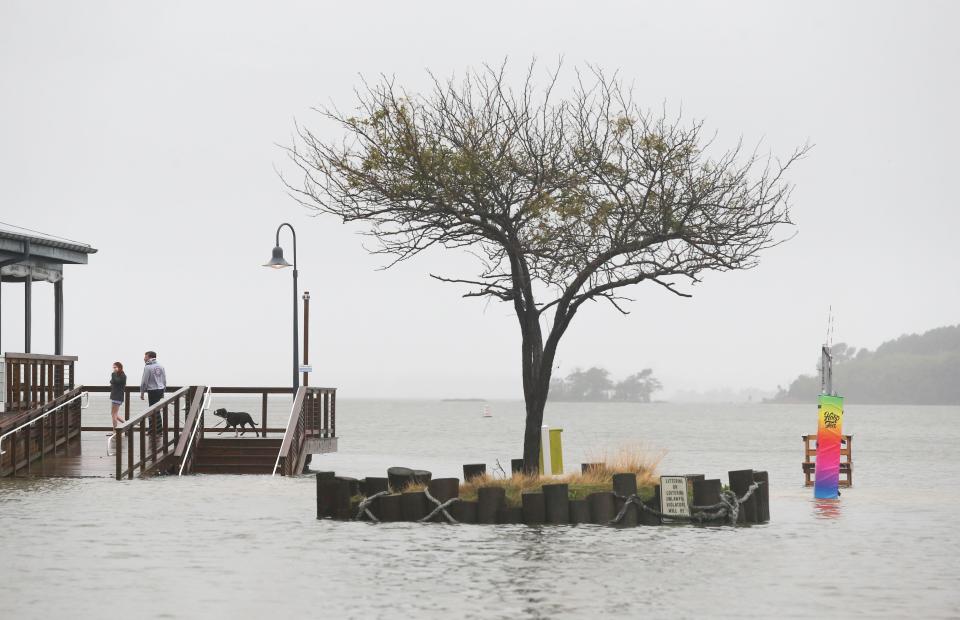
Bayside developments, mobile home parks see usual flooding
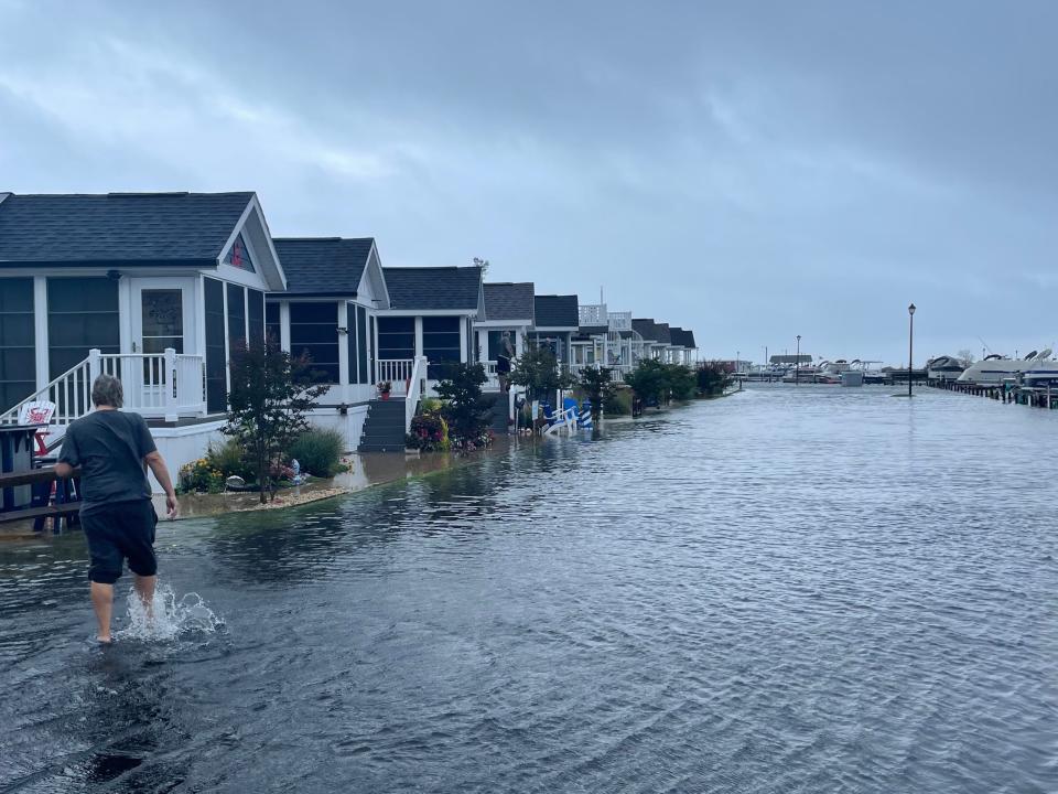
Waters were slow to recede post-high tide Saturday night, leaving bayside developments with the flooding that often comes with big storm surges.
North Drive in West Bay Park was completely flooded out as a person waded through the water toward the tiny homes set up across from the marina around 5 p.m. Saturday.
Long Neck Road was also closed at Fairfield due to water on the roadway.

In the Angola area of Lewes, Bookhammer Landing Road was also flooded. There are about 40 homes beyond a sign touting Joy Beach, with Rehoboth Bay gray but visible in the distance at the end of the road.
Delaware beaches swamped post-high tide
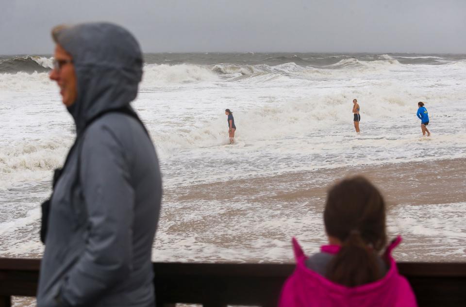
High tide hit the Delaware beaches at 3 p.m. Saturday, but waves showed no signs of receding by 4:30 p.m.
Gusty winds were expected to remain in the region through the evening, which could leave the coastline facing high waters into the evening.
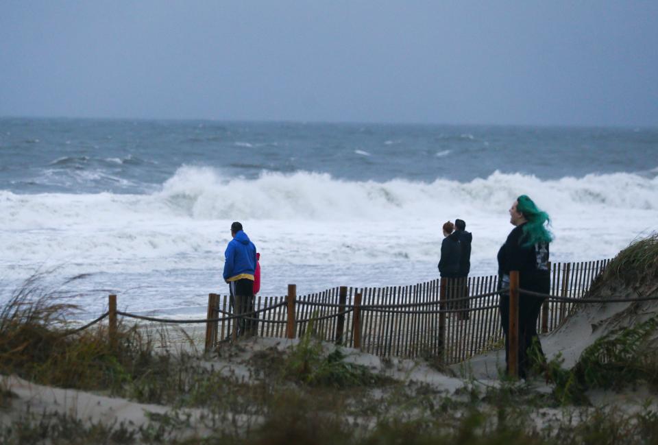
Flooding, road closures hit Delaware beaches

About 2 p.m. Saturday, as Delaware beaches prepped for an extremely high tide amid the storm, the parking lot at Savannah Beach in Lewes was closed and filled with sand. Police vehicles blocked the entrance to the parking lot at the beach located at the end of Savannah Road.
On Lewes Beach, waves crashed and covered the beach by 2 p.m. except for a small slice next to the jetty which was quickly disappearing.
At about 6:30 p.m., Route 1 south (Coastal Highway) was closed at the south end of Dewey Beach.
High tide is expected to peak just before 3 p.m. Saturday.
Delaware Department of Transportation traffic cameras near the Indian River Inlet did not show any Route 1 flooding as of 2:10 p.m. Saturday. One camera did show multiple onlookers braving the wind along the beach for photos.
Storm tracker Delaware
Here's the latest radar for where the storm is moving throughout Delaware.
National Guard mobilizing in Delaware
The Delaware National Guard was activated as a result of the storm, according to the Delaware Emergency Management Agency. They were to be in place by 1 p.m. Saturday to aid in storm response, and additional resources were standing by across the state to respond as needed.
Areas of major flooding concern in the state, according to DEMA, include low-lying coastal areas in Kent County, as well as the Long Neck and Oak Orchard areas in Sussex County.
Closings due to the storm
The Delaware Department of Natural Resources and Environmental Control closed campgrounds in coastal areas Saturday, according to the Delaware Emergency Management Agency. Some Sussex County mobile home parks also had power shut off to prevent transformer inundation.
Rainfall totals across the state
As of 11 a.m. Saturday, the highest rainfall estimate over the past 24 hours was recorded in Dagsboro with 2.72 inches, according to the Delaware Environmental Observing System.
The system's data also reported the following findings during the past 24 hours:
Delmar: 2.47 inches
Claymont: 1.10 inches
Bethany Beach: 2.07 inches
Rehoboth Beach: 1.96 inches
Dover: 1.59 inches
Wilmington: 1.20 inches
Seaford: 0.92 inches
Newark: 1.48 inches
Hockessin: 1.29 inches
Street flooding in Bethany Beach
Accuweather reports that several streets in Bethany Beach have been flooded, with some barriers being knocked down by the wind.
Accuweather's Bill Wadell was live from the north side of Bethany Beach Saturday morning, standing in a street covered with water. He also shared video from before sunrise of waves and wind hammering the boardwalk in both Bethany and Rehoboth Beach.
Gusty winds battering Delaware beaches
Winds were strongest in Lewes on Saturday morning, peaking at 64 mph as of 8 a.m., according to the National Weather Service.
Gusts also peaked at 58 mph in Dewey Beach Saturday morning, the weather service said.
Peak wind gusts as of 8 AM:
1. Lewes, DE: 64 MPH
2. North Beach Haven, NJ: 62 MPH
3. Sea Isle City, NJ: 61 MPH
4. Dewey Beach, DE: 58 MPH
5. Tuckerton, NJ: 52 MPH— NWS Mount Holly (@NWS_MountHolly) September 23, 2023
Power outages popping up across Delaware
As of Saturday morning, at least 4,000 customers have lost power in Delaware, especially in Sussex County where the majority of the outages occurred, according to poweroutage.us.
Live cameras from the Delaware beaches show waves and heavy winds battering the coastline.
Will the heavy rain and wind mean flooding?
Yes. Coastal flooding hit the area Saturday evening and was expected Sunday for the Delaware beaches and coastal New Jersey. Flooding could also affect parts of Maryland's Eastern Shore, as the storm continues to go north.
Downed trees and power lines resulting in localized power outages are also possible, according to the weather service.
On Saturday, heavy rain will be accompanied by breezy temperatures near 64 degrees in the Delaware area. Rain is expected to last into Sunday, according to the NWS.
Weekend forecast
Strong winds are expected from mid-morning through early Saturday noon. Gusty winds of 30 to 45 mph in most parts of Delaware will continue Saturday night but not be as strong. Temperatures will drop to around 59 degrees Saturday night.
The weather service predicts rain to last through Sunday morning with northeast winds around 15 mph. However, rain is expected to taper off Sunday night.
Ophelia: Watch live cams from Rehoboth Boardwalk, Lewes Yacht Club
This story includes reporting by the Associated Press.
Are you being impacted by the storm? Contact reporter Cameron Goodnight at cgoodnight@delawareonline.com or by calling or texting 302-324-2208. Follow him on Twitter at @CamGoodnight.
This article originally appeared on Delaware News Journal: Delaware beaches take beating from winds, waves as storm moves through

