Tropical storm warning in effect through the weekend up to parts of Delaware, East Coast
A tropical storm warning for a potential tropical cyclone has been issued through the weekend for parts of Delaware and other states along the East Coast.
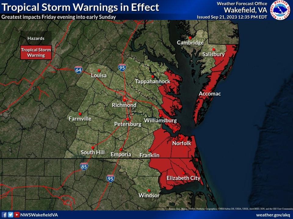
The National Weather Service in Wakefield, Virginia, said the tropical storm warning is in effect for northeast North Carolina, eastern Virginia, southeast Maryland and Fenwick Island. It also includes the Chesapeake Bay south of Smith Point, and Albemarle and Pamlico Sounds.
At about 2 p.m. Thursday, potential tropical cyclone No. 16 was located about 355 miles southeast of Charleston, South Carolina, moving north at about 9 mph with sustained winds of 35 mph, forecasters with the National Hurricane Center said.
The storm potentially will develop into Tropical Storm Ophelia after it likely reaches the North Carolina coast by Friday afternoon or evening, forecasters said.
11am EDT Key Messages for Potential Tropical Cyclone #Sixteen. Strong winds, storm surge, heavy rain, and high surf expected for portions of the southeast and mid-Atlantic U.S. coasts. Tropical Storm Warnings and Storm Surge Watches are in effect. https://t.co/tW4KeGdBFb pic.twitter.com/ZvJDUJiRvD
— National Hurricane Center (@NHC_Atlantic) September 21, 2023
Events moving or being canceled
The threat of a potential tropical cyclone is causing some to cancel or postpone weekend events.
Delaware State Police announced they were moving their 100th Anniversary 5K Run/Walk from this Saturday to Oct. 29. The 9 a.m. event will still take place at the Starboard, located at 2009 Coastal Highway, Dewey Beach, and benefit Camp Barnes, an overnight residential camp run by state police that is open to children between the ages of 10 and 13 at no cost to the camper or family.
The event's preregistration closing was also moved to Oct. 26.
The 2023 Special Olympics of Delaware Truck convoy scheduled for Saturday was canceled. A Special Olympics Delaware official said there would be no makeup date.
Weather conditions when the tropical storm hits
The storm will bring heavy rain and windy conditions late Friday into early Sunday with 1 to 4 inches of rain expected, according to the weather service.
The highest rainfall totals will be east of I-95 with localized flooding possible, especially in urban and poor drainage areas, forecasters said.
Wind gusts from the north and northeast could reach 45 to 55 mph near the coast late Friday into early Sunday. Downed trees and/or power lines and scattered power outages are possible.
Forecasters said the strongest winds should be from Friday afternoon through Friday night and into Saturday though the exact duration remains uncertain. Peak gusts could reach up to 60 mph.
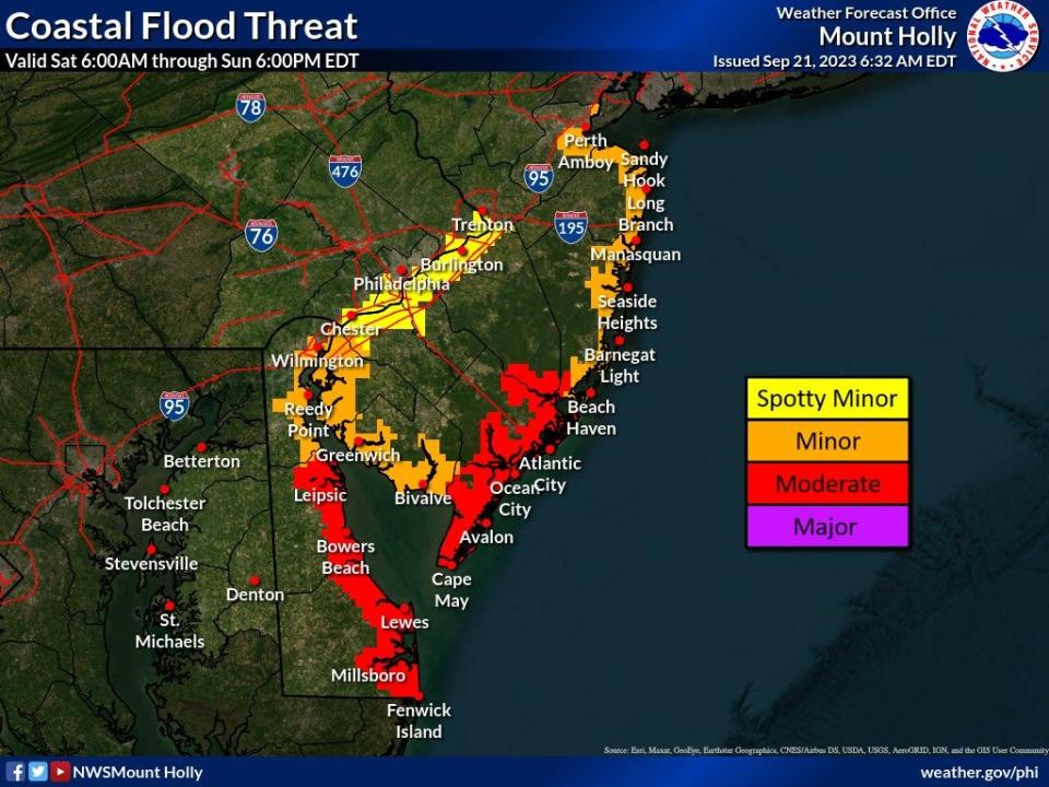
Moderate tidal flooding is forecast with the high tides late Friday night/early Saturday and again Saturday afternoon, forecasters said. Inundation of up to 2 to 4 feet above ground level is possible in vulnerable areas, they added.
Wet weekend: Storm moving up East Coast brings rain, possible flooding, more to Delaware this weekend
Natural disaster prep guides: Here's how to keep safe and tips in case of a flood, tornado or heat wave hits Delaware
Hot Delaware summer: Was this the hottest summer ever in Delaware? That, plus what recent temperatures mean
This article originally appeared on Delaware News Journal: Tropical storm warning for weekend up to parts of Delaware, East Coast

