Tropical Storm Warning For Much Of NJ As Isaias Picks Up Speed
NEW JERSEY — A tropical storm warning has been issued for much of New Jersey as Tropical Storm Isaias turned away from the Florida coast and moved north on Monday morning.
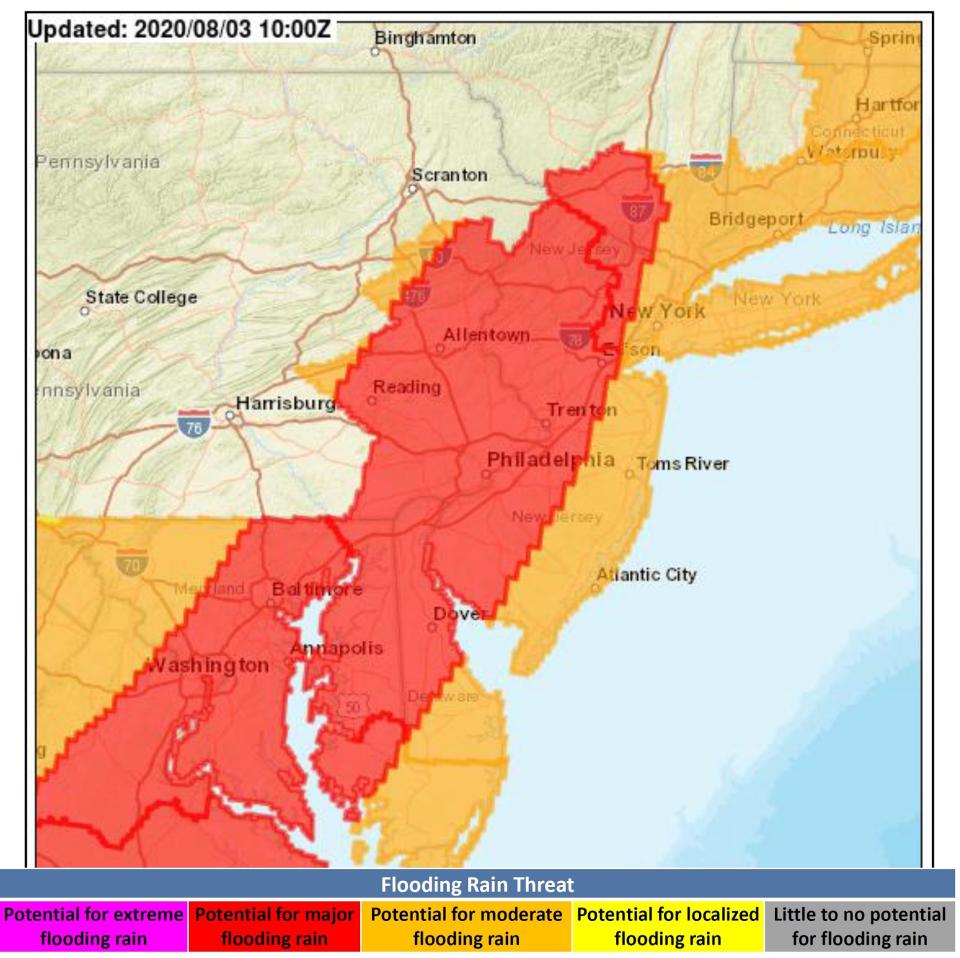
Heavy rain is expected with the potential for flash floods all across the state as Isaias continues the north-northeast trek, the National Weather Service's Mount Holly office said Monday morning.
Tropical storm-force winds and some rain likely will arrive by daybreak on Tuesday. Isolated tornadoes are possible as well, the weather service said.
Coastal counties — Cape May, Atlantic, Ocean, Monmouth and Middlesex — along with Hudson, Bergen and Essex, and parts of Gloucester and Burlington counties were under a tropical storm warning, while the rest of the state except for Sussex and Warren were under a tropical storm watch as of 7 a.m. Monday, the weather service said.
"We are concerned it's going to be a statewide event," New Jersey State Police Superintendent Col. Patrick Callahan said Monday during the state's coronavirus briefing. Callahan said state officials were hearing some areas of the state could receive as much as 8 inches of rain.
The highest winds are expected between 1 p.m. and 8 p.m., Callahan said.
"By late Tuesday or early Wednesday we hope it's gone," he said.
Isaias was expected to regain hurricane status later Monday as it moved north toward the Carolinas, where it was expected to make landfall. The National Hurricane Center's 8 a.m. briefing said Isaias had picked up speed, moving north-northeast at 13 mph, and had maximum sustained winds of 70 p.m.
Tropical storm-force winds mean New Jersey residents should be prepared for power outages as tree and power line damage. Gusts of more than 73 mph — near hurricane force — are possible along the shore, the weather service said.
The primary concern, forecasters said, is the expected heavy rain. Rainfall totals of 2 to 4 inches are predicted for much of the state, with western parts of the state — Salem County in the south and Warren and Hunterdon counties to the north — seeing as much as 6 inches. Some river flooding is possible, although forecasters said the main stem of the Delaware River is not expected to flood.
There is a potential for coastal flooding from a 1- to 3-foot storm surge, though forecasters said the highest potential for that is in the Chesapeake Bay area. But lowlying areas that flood regularly with heavy rainstorms or extreme high tides likely will be flooded as a result of Isaias.
High tide arrives along the coast mid-morning on Tuesday, between 8:45 and 9:30 a.m. depending on the location along the coast, which will increase the effect of any storm surge from Isaias.
Beachgoers should expect swimming closures as increased swells and rip current risk continue along the coast through at least Wednesday.
"Rip currents can be deadly," Callahan said, urging people to not swim alone and to heed posted warnings about rough surf.
In advance of the storm, Hoboken officials have prohibited driving in the city starting at 8 a.m. Tuesday, due to anticipated flooding there. Two storms in July, including Tropical Storm Fay, resulted in flash floods that stranded cars in the city. Read more: Hoboken Bans Driving During Tropical Storm Isaias Tuesday
Click here to get Patch email notifications, or get Patch breaking news alerts sent right to your phone with our app. Download here. Have a news tip? Email karen.wall@patch.com Follow Brick Patch on Facebook.
This article originally appeared on the Brick Patch

