Isaias has become a Category 1 hurricane as it heads toward Bahamas and South Florida
Isaias is now a hurricane.
The National Hurricane Center upgraded the former tropical storm around midnight. The Category 1 storm continues on track toward the Bahamas and South Florida.
Hurricane Isaias has lost some forward speed but has grown more powerful, with 80 mph winds, shortly after passing through Hispaniola. The storm has flooded roads and homes in Puerto Rico and blown roofs away in Haiti.
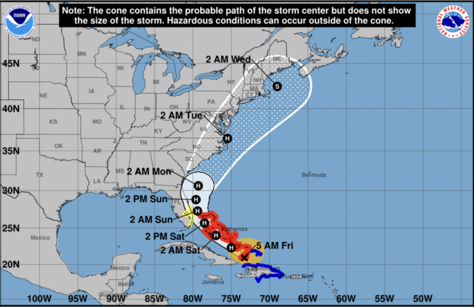
Isaias is moving toward the northwest at 17 mph and is expected to bring hurricane conditions to portions of the Bahamas on Friday, according to the hurricane center. The storm is about 15 miles south-southeast of Great Inagua Island and about 385 miles southeast of Nassau, according to the hurricane center’s 5 a.m. Friday update.
The forecast shows the hurricane moving near or over the Southeastern and Central Bahamas Friday and then moving near or over the Northwestern Bahamas and near South Florida on Saturday and Sunday.
“Some strengthening is possible today, and Isaias is expected to remain a hurricane for the next few days,” and while there appears to still be some “uncertainty” in the storm’s track, there is a “notable chance of a hurricane moving close to the U.S. East coast, so the forecast continues to show that scenario,” forecasters wrote in the advisory.
Water temperatures along Isaias’ predicted path are running three to four degrees above normal, which could fuel a stronger storm. Higher sea surface temperatures are one of the main ways climate change is affecting hurricane formation, and the record-setting heat seen in this region over the summer is one of the reasons scientists predicted this would be an active hurricane season.
As of Thursday evening, the National Weather Service predicted that Miami’s peak winds could be 23 mph with 34 mph gusts around 1 a.m. Saturday. In Fort Lauderdale, they could be 20 mph with 30 mph gusts Saturday around 7 a.m. In Palm Beach, it could be 25 mph winds with 38 mph gusts around 9 p.m. Saturday.
At a Thursday evening news briefing, Gov. Ron DeSantis urged Floridians to be prepared with seven days of food, water and medicine.
“While we can’t be certain of the exact track of the storm, and we certainly can’t be sure about the intensity it’s expected to reach, we do expect to see impacts to the state of Florida, even if the storm remains off our shore, which is the current forecast,” he said.
Florida watches and warnings
A tropical storm watch is in effect for the east coast of Florida from Ocean Reef northward to the Sebastian Inlet and Lake Okeechobee, with tropical storm conditions possible in the watch area Saturday, according to the hurricane center.
Forecasters say additional watches or warnings may be required for a portion of the Florida peninsula later Friday.
South Florida into east-Central Florida is forecast to see between two to four inches of rain, with isolated areas seeing possibly up to six inches of rain from Friday night through Monday. There is also a risk of isolated flash and urban flooding, “especially in low-lying and poorly drained areas,” according to the hurricane center.
Miami-Dade County also announced that all facilities operated by the Miami-Dade County Parks, Recreation and Open Spaces Department, including beaches and parks, will close by 8 p.m. Friday in preparation for the storm. State-supported COVID-19 testing sites across Florida will also be closed at least until Tuesday morning.
Neither Miami-Dade nor the state plan to open shelters under the current prediction of a Tropical Storm, dodging — for now — a test of the efficacy of plans to enforce COVID screening and social distancing within hurricane shelters.
“We have 20 shelters basically on stand-by. We’ve sent the equipment that’s needed to open them,” Mayor Carlos Gimenez said in an online press conference Thursday from the county’s Emergency Operations center in Doral before the NHC upped Isaias to a likely hurricane. ”At this point, we’re not opening them,” he said. “We may pull the trigger on opening some shelters, depending on the forecast strength and the direction.”
Other watches and warnings
The Bahamas are the first region to issue a hurricane warning for Isaias. Hurricane warnings were issued for the Northwestern Bahamas, which includes the Abacos Islands, Grand Bahamas Island and Andros Island; the Northwestern Bahamas including Andros Island, New Providence, Eleuthera, Abacos Islands, Berry Islands, Grand Bahamas Island, and Bimini; the Southeastern Bahamas including the Acklins, Crooked Island, Long Cay, the Inaguas, Mayaguana, and the Ragged Islands; and the Central Bahamas, including Cat Island, the Exumas, Long Island,Rum Cay, and San Salvador.
Tropical storm warnings are still in effect for the Dominican Republic’s entire southern and northern coastlines. Warnings are also in effect along the north coast of Haiti from Le Môle, St.-Nicholas eastward to the northern border with the Dominican Republic, the Turks and Caicos Islands.
Tropical storm watches are in effect for the Northwestern Bahamas including Andros Island, New Providence, Eleuthera, Abacos Islands, Berry Islands, Grand Bahamas Island and Bimini.
How the storm is affecting the Caribbean
In Port-de-Paix in Haiti’s northwest region, tops were blown off houses by Isaias’ gusty winds and rains that came on and off through Thursday. The outdoor markets were closed, and the wooden sloops that normally transport Haitians between the city and the island of Île de la Tortue also ceased operation due to the rough seas. Making the day equally difficult for many in the city is a shortage of fuel that paralyzed public transport.
In Puerto Rico, Isaias’ heavy rain flooded streets and homes and caused landslides that blocked mountain roads. Municipalities in the center of the Island like Aguas Buenas and Aibonito saw water levels rise in rivers and cause flash flooding. Close to the coast in Mayagüe, the rain accumulation caused the Yagüez river to flood the town in residential areas, leaving thousands of homes underwater.
The 60 mph winds and higher gusts blew over trees and power lines, causing major blackouts around the island. According to the Electric Energy Authority of Puerto Rico, around 400,000 families were without power Thursday morning, which represents 25 percent of its clients.
“The emotional state of people is deteriorating more every day,” Santos Seda, mayor of the southwest town of Guánica, told The Associated Press.
Bahamas Prime Minister Hubert Minnis asked Bahamians to take the approaching storm seriously and again urged them “to prepare for the worse just in case.”
All government offices will close at noon Friday to allow people to prepare for the storm, Minnis announced. He also said this weekend’s COVID-19 lockdown, put in place to try and stem the tide of rising coronavirus cases, will be relaxed to allow people to prepare for the storm. The hours of supermarkets and other stores will be extended and individuals will be allowed to move around.
Effective Friday, a curfew will be in place from 10 p.m. to 5 a.m. until further notice.
Based on current indicators and data provided, a lockdown will still be necessary following the passage of this storm, Minnis said. “Much stronger protective and mitigation measures are absolutely necessary and will have to be implemented,” he said.
He also told Bahamians that the country remains in the midst of a pandemic and if they do not act responsibility, the consequences could be dire. He begged them not to use the storm to go “socializing” and meeting with friends and family.
“The situation we are in is very fast-moving and fluid,” he said.
Minnis also appealed to the country’s youth, who have been booking reservations at local hotels to wait out the hurricane. Minnis asked them not to engage in COVID-19 or hurricane parties.
“Use that time for security and safety please. Do not engage in a hurricane or Covid party. It will not help us and it can be devastating. We will see the after effects, if not in two weeks, possibly later,” Minnis said.
While the Bahamas is still recovering from the devastating effects of last year’s Hurricane Dorian, which slammed the islands of Grand Bahama and the Abacos, it is also dealing with a surge in coronaviurs cases after fully reopening its borders on July 1. The surge first led to announcing a travel ban for U.S. travelers. It has since amended it by saying all visitors are welcomed but will need to quarantine -- at their own expense -- in a government facility for 14 days and take a COVID-19 test before being discharged.
Miami Herald staff writers Douglas Hanks, Jacqueline Charles and David Goodhue and el Nuevo Herald writer Salomé Ramírez Vargas contributed to this report.

