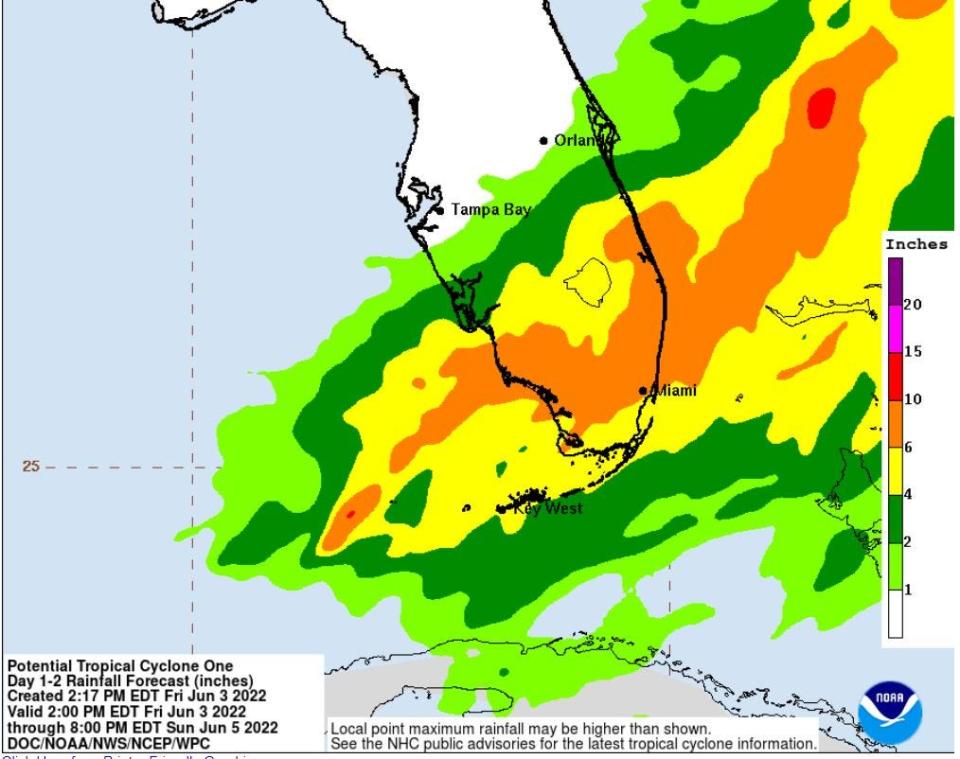
Tropical system could bring a foot or more of rain to some areas of South Florida
The tantrum of thunderstorms in the southern Gulf of Mexico struggled to gain purchase Friday on its well-worn path toward the Sunshine State but was still expected to make a pre-dawn landfall Saturday as a tropical storm and pour more than a foot of rain on some areas of South Florida.
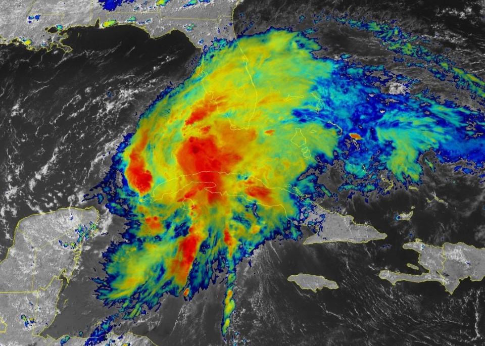
Screaming wind shear kept Potential Tropical Cyclone One from graduating to Tropical Storm Alex as of the 5 p.m. advisory from the National Hurricane Center, which forecast the system to gain full tropical storm status before reaching the southwest coast with 45-mph winds.
Although not a true tropical storm Friday because it had no closed center of circulation, it did have the qualifying 40-mph winds, which extended 70 miles from the middle of the system.
Palm Beach County was forecast to begin feeling the strongest winds near 8 a.m.
National Hurricane Center: Forecasts began May 15, and they're better than ever
Scary trend: Major hurricanes in October and November — why is it happening?
Florida hurricane season: Where can I find hurricane shelters open near me?
Widespread rain of 4 to 8 inches with isolated spots of up to 15 inches is the chief concern with the system, which also could come with tornadoes and 1 to 3 feet of storm surge on west coast beaches. The are from the Florida Keys to North Miami Beach could get 1 to 2 feet of storm surge.
“The winds are really going to be a non-factor in this,” said Miami-based National Weather Service meteorologist Chuck Caracozza. “It’s going to be the waves of heavy rainfall.”
At 5 p.m. Friday, the system was 350 miles southwest of Fort Myers and moving northeast at 7 mph.
It was forecast to make landfall anywhere from Port Charlotte to south of Naples with the center of the NHC’s track skimming just north of Bonita Springs. The center of the path then takes it over Lake Okeechobee with an exit near Port St. Lucie.
It is expected to clear the state by early evening.
“I’m hoping this will be a good dry run for hurricane season,” said Lake Worth Drainage District Executive Director Tommy Strowd. “The rain forecast kind of puts it at the upper end of the design limit for most drainage systems, and I think things will get full but I don’t think there will be big problems.”
Torrential rains will hit us before the strongest winds
Because the system is getting walloped by westerly wind shear, much of the rain is pushed far to its east. That means torrential rains will precede the strongest winds.
“The rain is actually beating the wind,” said Gov. Ron DeSantis on Friday. “No one’s going into emergency posture yet.”
Some outdoor activities are closed Saturday because of the squally weather, including Lion Country Safari’s walk-through park. Its drive-through safari will be open at a reduced rate of $20 per person. Rapids Water Park was closed Friday but no decisions on closing Saturday had been made by late Friday afternoon. The Palm Beach Zoo had also made no decisions about closing Saturday but it said to check its social media sites for updates.
West Palm Beach suspended its downtown trolley service starting at 7 p.m. Friday.
“People can still go to the Flagler Museum, Norton Museum, Cox Science Center, the Palm Beach Outlets or The Gardens Mall,” said Rick Netzel, director of sales and marketing at the Best Western on Palm Beach Lakes Boulevard.
Netzel said he’s heard no grumbling from guests about the soggy weather. His hotel is about 75% full this weekend.
“We’ve been handing out Best Western umbrellas,” he said.
Hurricane season concerns: Influx of newcomers, COVID variants and supply chain issues
CSU, AccuWeather forecasters agree: Active hurricane season ahead. Here's what you need to know
2022 hurricanes names: See the list of names for the Atlantic hurricane season
This potential system was aided by pieces of Hurricane Agatha
Potential Tropical Cyclone One came to life with the help of the remnants of Hurricane Agatha and the Central American gyre — an area of low pressure that bookends hurricane season and typically dissipates when the stronger easterly winds of summer move in.
As a Pacific storm, Hurricane Agatha caused flooding and mudslides that killed at least 11 people and left 20 missing in Mexico, officials said. It caused rivers to overflow their banks and swept away people in homes, while other victims were buried under mud and rocks.
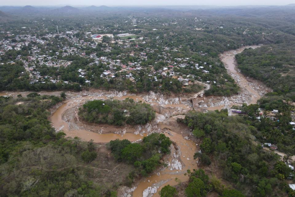
Agatha made history as the strongest hurricane ever recorded to come ashore in May during the eastern Pacific hurricane season since 1949.
Hurricane season began June 1. This is the first year since 2015 that a named storm didn’t form ahead of the official start date.
Florida Power & Light: How FPL's new $1.2 million fixed-wing hurricane drone will work and what it will do
Extreme weather: Deadly Texas storm motivates Florida Power & Light to prepare for extreme winter weather
As of 4 p.m. Friday, areas of Wellington, Loxahatchee, Boca Raton and West Palm Beach had already received between 1.5 and 2 inches of rain in the previous 24 hours, according to Citizen Weather Observer Program gauges gathered by MesoWest. The official NWS gauge at Palm Beach International Airport measured 0.33 inches for the day. Naples measured 1.57 inches. Fort Lauderdale received 1.18 inches.
The U.S. Army Corps of Engineers said Lake Okeechobee was at 12.59 feet above sea level Friday. Traditionally, the Corps has tried to keep the lake at 12.5 and 15.5 feet above sea level to ensure the integrity of the Herbert Hoover Dike.
“We are encouraged because the lake is in a very good place right now,” said Jacksonville District Deputy Commander for South Florida Lt. Col. Todd Polk.
The Corps suspended releases from the lake until the storm passes.
“The story here is all about the moisture,” said National Hurricane Center Director Ken Graham about the system. “Most of the fatalities in these tropical systems is water and mostly from inland flooding.”
This article originally appeared on Palm Beach Post: Florida watching tropical system with landfall expected early Saturday

