A fifth tropical system pops up in the already packed Atlantic. One will affect Florida
The party doesn’t seem to be slowing down in the Atlantic Ocean as a fifth tropical system is now being tracked by the National Hurricane Center. One system has developed into a tropical depression on Saturday afternoon.
Another disturbance, which is heading for the Gulf of Mexico, will bring some gloomy weather to South Florida.
The Florida Keys and South Florida, including Miami-Dade and Broward, could see some breezy winds, possibly 10 to 15 mph, in some areas. Rains also may trigger more flood advisories that have plagued the region over the past month.
The peak of the Atlantic hurricane season is Sept. 10, with most activity occurring between mid-August and mid-October.
Here’s what National Hurricane Center specialists wrote in the Hurricane Center’s 2 p.m. Saturday advisory:
Where’s Tropical Depression 6?
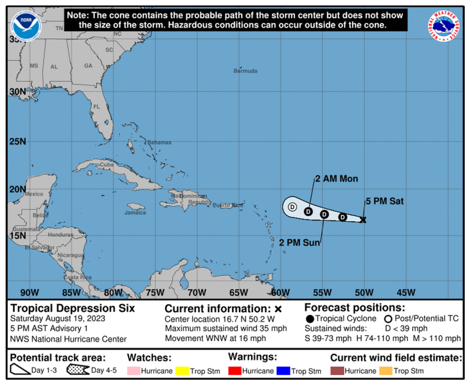
The sixth tropical depression of the 2023 hurricane season formed around 5 p.m. Saturday. Forecasters don’t expect it to be around long.
It is about 855 miles east of the Northern Leeward Islands and traveling west-northwest at 16 mph, the hurricane center said. It has maximum sustained winds near 35 mph with higher gusts.
The depression is forecast is to weaken over the next day or so, becoming a remnant low by Monday.
No coastal watches or warnings are in effect.
Where’s the newest tropical system?
A tropical wave is being tracked near the western coast of Africa and is producing a large area of disorganized showers and thunderstorms.
“Some slow development is possible while it moves generally west-northwestward across the tropical eastern Atlantic during the next several days,” the hurricane center said.
▪ Formation chance through 48 hours: near 0%.
▪ Formation chance through 7 days: 20%.
How about the one heading for the Gulf?
The Hurricane Center is watching a disturbance near the northwestern and central Bahamas that is forecast to move into the Gulf of Mexico by early next week.
A tropical depression could form as it moves west approaching the western Gulf of Mexico coastline by the middle of next week, forecasters said.
▪ Formation chance through 48 hours: 10%.
▪ Formation chance through 7 days: 50%.
“The quick pivot from an empty ‘tropical storm formation not anticipated’ NHC map to one crowded with possible hurricane seedlings is having its moment on social media”
My analysis on the suddenly busier Atlantic https://t.co/F1CLELxhu7— John Morales (@JohnMoralesTV) August 18, 2023
What’s going on with Disturbance 1?
An area of low pressure in the eastern tropical Atlantic several hundred miles west of the Cabo Verde Islands is showing signs of organization with showers and thunderstorms.
“Environmental conditions appear generally favorable for further development of this system, and a short-lived tropical depression is likely to form this weekend while it moves west-northwestward or northwestward at about 10 mph across the eastern tropical Atlantic,” according to the advisory.
But upper-level winds over the system are forecast to increase so further development is not expected early in the week.
▪ Formation chance through 48 hours: 70%.
▪ Formation chance through 7 days: 70%.
It "looks" very busy out there, and there are several areas of interest, but only the feature in the eastern Atlantic (red blob) has any real short term potential for development.
Remember, beginning this year the outlook has been increased to cover 7 days of potential… pic.twitter.com/KSWhnUgRdn— Craig Setzer (@CraigSetzer) August 18, 2023
Where’s Disturbance 3?
Near the Windward Islands, a broad area of low pressure is becoming better organized.
A tropical depression could form by early next week while the system moves west to west-northwest at 10 to 15 mph, across the Lesser Antilles and over the eastern and central Caribbean Sea.
“Regardless of development, heavy rainfall is possible over portions of the Windward Islands during the next couple of days. Interests in the eastern and central Caribbean should monitor the progress of this system,” the hurricane center said.
▪ Formation chance through 48 hours: 40%.
▪ Formation chance through 7 days: 60%.
Will they affect Florida?
The fourth system over the southeastern Bahamas and set to go into the Gulf of Mexico will move over South Florida this weekend. As it travels overhead, it will bring higher rain chances.
The National Weather Service of Miami said different round of showers and thunderstorms could have the region seeing torrential downpours that may produce urban flooding, including roadways and low-lying areas covered in water.
But if the system develops next week it will have moved beyond the state and into the western Gulf of Mexico coastline area.
4 areas across the Atlantic being monitored by NOAA NWS National Hurricane Center for development over 7 days.
Area #4 will move across the #FlKeys as a broad tropical wave on Sat/Sun, accompanied by increasing rain chances and freshening breezes.
Visit https://t.co/BQCTvCzxKU! pic.twitter.com/Ea246v7dZS— NWS Key West (@NWSKeyWest) August 18, 2023

