As the tropics boil, a cautiously optimistic August hurricane forecast for Florida
One of the traditions of the late Dr. Bill Gray — forefather of seasonal hurricane predictions and great-great-grand-doctoral advisor to the WeatherTiger — was ringing a bell on August 20th to mark the beginning of the most active six weeks of hurricane season.
One of my core beliefs is that Florida deserves a more culturally specific version of this rite of passage. Perhaps dumping some bath salts into Biscayne Bay, ceremonially placing jorts on Michaelangelo’s David, or even releasing unwanted exotic reptiles into a pristine wilderness might dispel hurricane season’s ill winds.
However one chooses to meditate on the peak, it is here: over 60% of the Atlantic’s total tropical activity occurs between August 20th and September 30th.
This year, that bell was even more of a starting gun than usual, with a remarkable four named storms developing in the Atlantic on August 20th and 21st.
Harold and Hilary claim their place in hurricane season history
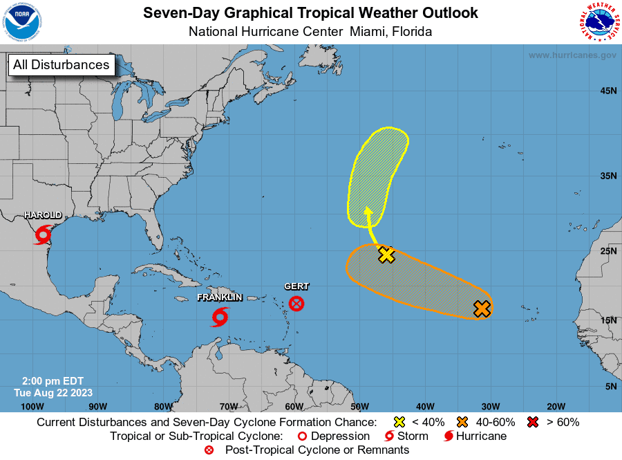
One of these, Tropical Storm Harold registered the first continental U.S. landfall of 2023* on Tuesday morning, rolling into Texas between Brownsville and Corpus Christi as a mid-range tropical storm packing beneficial rainfall.
This storm was organizing quickly in its final hours due to the friction between air and land that sometimes causes a pre-landfall pop in intensity, and smoldering water temperatures in the upper 80s. Another day over water and it likely would have been a dangerous hurricane.
(*Unusual caveat: Harold was the first Atlantic-side continental U.S. landfall of 2023, as Tropical Storm Hilary claimed first U.S. landfall on Sunday night when its weakening center moved straight into Compton, preceded by flooding rains across much of the Southwest. If verified, Hilary will be only the second tropical storm landfall in California on record, the first since 1939, and the only one to be accompanied by a random-but-seemingly-portentous magnitude 5.1 earthquake.)
Does Harold herald additional landfalls? For the U.S., not in the short- or medium-term.
Could Franklin become the second Atlantic hurricane of 2023?
The other active storm today is Tropical Storm Franklin, which has moved little for several days to the south of Hispaniola. Franklin has been struggling under strong wind shear and is likely to continue to do so as it crosses Haiti and the Dominican Republic by Thursday, potentially bringing flash floods.
Fortunately, a trough of upper-level low pressure in the western Atlantic will turn it east and away from land later this week, and Franklin the Energy Turtle is extremely unlikely to ever threaten the U.S. East Coast. It may well become a hurricane as it accelerates north towards Bermuda and eastern Canada in 7 to 10 days.
Befitting the strange and difficult 2023 hurricane season, two other storms stumbled out of the blocks and crashed into the first hurdle earlier this week.
Both Emily and Gert were open-ocean systems lasting less than two days at tropical storm intensity, officially making them short-lived storms, or “shorties.” So while 2023 has notched an impressive nine storms, it also has had more shorties than a Wawa during Hoagiefest, with five of those nine blipping quickly out of existence.
What to watch over the next 10 days: Inklings of a possible Gulf threat?
That total may not rise soon, but there are a few features to watch for possible development over the next ten days. At this time of year, every tropical wave emerging from Africa has at least a puncher’s chance of development, but a break from east Atlantic activity into the weekend is a good bet.
A possible feature worth watching for Florida is the chance that a broad area of low-level turning near Central America may coalesce into a more organized tropical disturbance over the southern Gulf of Mexico or northwest Caribbean by the middle of next week.
Should this happen, it would be a concern for the U.S. Gulf Coast as steering currents around an eastern U.S. dip in the jet stream might try to pull anything that develops north. There is literally nothing to watch on the map right now and may never be, so this is just a long-range heads-up based on the weather pattern, not a cause for alarm.
Cautious optimism for landfall risk for rest of August
For now, the landfall risk outlook for the remainder of August is cautiously optimistic, given that upper-level steering winds should protect the U.S. from any classic peak season hurricane threats from the east for at least the next 10 days.
However, the widespread water temperatures south and west of Florida pushing 90 degrees are unprecedented and alarming. If the Gulf was a drink, it would be Long Island iced tea: potential bad decisions in every direction.
Pour a ceremonial libation of your choice in the hope that we can dodge the peak season of hurricane season without tapping that potential. Keep watching the skies.

Dr. Ryan Truchelut is chief meteorologist at WeatherTiger, a Tallahassee start-up providing forensic meteorology and expert witness consulting services, and agricultural and hurricane forecasting subscriptions. Get in touch at ryan@weathertiger.com, and visit weathertiger.com for an enhanced, real-time version of our seasonal outlook.
This article originally appeared on Tallahassee Democrat: Hurricane forecast for Florida: Does Harold, heat point to trouble?

